Nations Online
All Countries in the World
Nations Online All Countries in the World | |
Home  |
___ Satellite View and Map of the City of Porto Alegre - Rio Grande do Sul
|
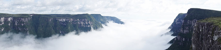 Fortaleza Canyon in the Parque Nacional da Serra Geral about 200 km north east of Porto Alegre. Image: Peter Dunne |
About Porto Alegre Satellite view showing Porto Alegre, the "Happy Harbor" on the eastern bank of the Guaíba lake, Brazil's tenth-biggest city is the capital of Rio Grande do Sul and one of the county's largest ports. Satellite view showing Porto Alegre, the "Happy Harbor" on the eastern bank of the Guaíba lake, Brazil's tenth-biggest city is the capital of Rio Grande do Sul and one of the county's largest ports. The city is situated at the northern end of Lagoa dos Patos (a large coastal lagoon) close to the southern end of The city is located in a subtropical zone and has therefore a humid subtropical climate, with the highest temperatures in December and January. 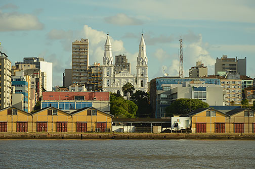 Parts of Cais Mauá pier at Porto Alegre, seen from lake Rio Guaíba, in center Igreja Nossa Senhora das Dores (Church of Our Lady of Sorrows) from the fifteenth century. Image: Lechatjaune Today the city has a population of about 1.5 million people, more than 4.4 million live in the metropolitan area. The Port of Porto Alegre is an important trans-shipment hub and the city itself a major industrial and commercial center in Brazil's South Region. 2014 FIFA World Cup The city was one of the twelve host cities of the 2014 FIFA World Cup. The five group matches were held in June 2014 at the Estádio Beira-Rio stadium (official name: Estádio José Pinheiro Borda). The Map shows a city map of Porto Alegre with expressways, main roads and streets, and the location of Porto Alegre Airport known as Salgado Filho International Airport (IATA Code: POA) located 6 km (4 mi) northeast of Downtown Porto Alegre. To find a location use the form below. (Map Help) |
|
| To find a location type: street or place, city, optional: state, country. |
Local Time Porto Alegre:
Friday-June-19 23:59
Brasília Time Zone (BRT): UTC/GMT -3 hoursDaylight Saving Time starts on the 3rd Sunday of October and ends on the 3rd Sunday of February shifts time offset to UTC/GMT -2 hours. |
|
φ Latitude, λ Longitude (of Map center; move the map to see coordinates): , |
||||||
| Google Earth: Searchable map/satellite view of the City of Porto Alegre, Rio Grande do Sul, Brazil. City Coordinates: 30°01′59″S 51°13′48″W |
Bookmark/share this page |
|||||
| More about Brazil: Cities - background notes and a searchable map/satellite view of other Brazilian cities: Largest cities in Brazil: Other Cities: Aracaju, Belém, Boa Vista, Campo Grande, Cuiabá, Florianópolis, Goiânia, João Pessoa, Macapá, Maceió, Natal, Palmas, Porto Alegre, Porto Velho, Recife, Rio Branco, São Luís, São Paulo, Teresina, Vitória Country: Continent: External Links Porto Alegre (official website) Salgado Filho International Airport Wikipedia: Porto Alegre Wikipedia entry: Porto Alegre |
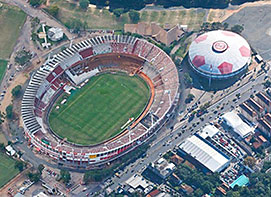 The Beira-Rio stadium, Porto Alegre Image: Google Earth Weather Conditions Porto Alegre
|
Explore more:
Related Consumer Information:
|
||||
Other Cities in South America: Asunción (Paraguay) - Bogotá D.C. (Colombia) - Brasilia, Rio de Janeiro, São Paulo, Salvador, (all Brazil) - Buenos Aires (Argentina) - Caracas (Venezuela) - Cayenne, Kourou (both French Guiana) - Georgetown (Guyana) - La Paz, Sucre (both Bolivia) - Lima (Peru) - Montevideo (Uruguay) - Paramaribo (Suriname) - Quito (Ecuador) - Santiago (Chile) |
||
Map Help [ show ] |
||
One World - Nations Online .:. let's care for this planet Promote that every nation assumes responsibility for our world. Nations Online Project is made to improve cross-cultural understanding and global awareness. More signal - less NOISE |
| Site Map
| Information Sources | Disclaimer | Copyright © 1998-2024:: nationsonline.org |

