Nations Online
All Countries in the World
Nations Online All Countries in the World | |
Home  |
___ Satellite View and Map of the City of Manaus - Amazonas |
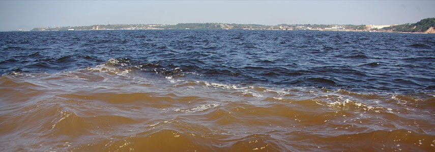 The Meeting of Waters (Portuguese: Encontro das Águas) is the confluence between the dark-colored cool waters of the Rio Negro and the sandy-colored warm Rio Solimões, together they form the Amazon River. Image: Nao Iizuka |
About the City of Manaus Satellite view showing Manaus, capital of Amazonas, the largest of the 26 Brazilian states. The city is located in northern Brazil close to the place where the Rio Negro and the Solimões river merge, this is the point where the Amazon River officially begins. Satellite view showing Manaus, capital of Amazonas, the largest of the 26 Brazilian states. The city is located in northern Brazil close to the place where the Rio Negro and the Solimões river merge, this is the point where the Amazon River officially begins. 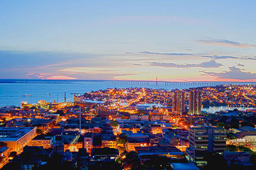 Central Manaus short after sunset. Image: União da Juventude Mestiça Today Manaus is Brazil's 7th largest city with a population of about two million people. It is the commercial center of Amazonia, a large urban conglomeration amidst the wilderness of the Amazon region, which by the way, represents more than half of the planet's remaining rainforests. Access to the city is primarily by boat or airplane. Manaus is a major port even for some ocean-going vessels, despite the fact that it lies about 1,500 km west of the Atlantic Ocean. The city is located in a tropical zone and has a monsoon climate with average temperatures in June, July of about 30° Celsius (88° F). 2014 FIFA World Cup The city was one of the twelve host cities of the 2014 FIFA World Cup. Four group matches were held at the Amazonia Arena (official name: Arena da Amazônia). The Map shows a city map of Manaus with expressways, main roads and streets. Zoom out to find the location of Manaus Airport known as Eduardo Gomes International Airport (IATA Code: MAO) located 13 km (8 mi) north west of the city center. To find a location use the form below. (Map Help) |
|
| To find a location type: street or place, city, optional: state, country. |
Local Time Manaus:
Saturday-July-25 01:55
Amazon Time (AMT): UTC/GMT -4 hoursDaylight Saving Time starts on the 3rd Sunday of October and ends on the 3rd Sunday of February shifts time offset to UTC/GMT -3 hours. |
|
φ Latitude, λ Longitude (of Map center; move the map to see coordinates): , |
||||||
| Google Earth: Searchable map/satellite view of the City of Manaus, Amazonas, Brazil. City Coordinates: 03°06′0″S 60°01′0″W |
Bookmark/share this page |
|||||
| More about Brazil: Cities - background notes and a searchable map/satellite view of other Brazilian cities: Largest cities in Brazil: Other Cities: Aracaju, Belém, Boa Vista, Campo Grande, Cuiabá, Florianópolis, Goiânia, João Pessoa, Macapá, Maceió, Natal, Palmas, Porto Alegre, Porto Velho, Recife, Rio Branco, São Luís, São Paulo, Teresina, Vitória Country: Continent: |
Current Weather Conditions Manaus
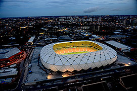 Arena da Amazônia (Amazonia Arena) in Manaus, Amazonas. Image: Brazilian Government External Links: Manaus (official website) Wikipedia: Manaus Wikipedia entry: Manaus |
Explore more:
Related Consumer Information:
|
||||
Other Cities in South America: Asunción (Paraguay) - Bogotá D.C. (Colombia) - Brasilia, Rio de Janeiro, São Paulo, Salvador, (all Brazil) - Buenos Aires (Argentina) - Caracas (Venezuela) - Cayenne, Kourou (both French Guiana) - Georgetown (Guyana) - La Paz, Sucre (both Bolivia) - Lima (Peru) - Montevideo (Uruguay) - Paramaribo (Suriname) - Quito (Ecuador) - Santiago (Chile) |
||
Map Help [ show ] |
||
One World - Nations Online .:. let's care for this planet Promote that every nation assumes responsibility for our world. Nations Online Project is made to improve cross-cultural understanding and global awareness. More signal - less NOISE |
| Site Map
| Information Sources | Disclaimer | Copyright © 1998-2024:: nationsonline.org |

