Nations Online
All Countries in the World
Nations Online All Countries in the World | |
Home  |
___ Satellite View and Map of the City of Goiânia - Goiás |
About the City of Goiânia Satellite view showing Goiânia, largest city and the capital of Goiás, one of the 26 Brazilian states. The city is located in the central part of 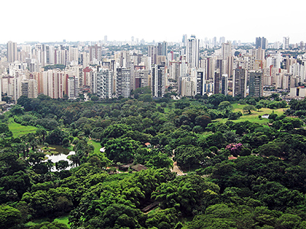 View of Goiânia skyline with Jardim Zoological Park in foreground. Image: Ian Nascimento Goiânia lies in a tropical savanna climate zone with a wet season from October to April, and it is dry from June to August. The average temperature is around 22° C. Goiânia's economy is based on a variety of industries especially the agricultural industry. Supply of agricultural equipment, tools, fertilizer and similar products, as well as the maintenance of related machines and vehicles drive the city's economy. The Map shows a city map of Goiânia with expressways, main roads and streets and the location of Goiânia Airport known as Santa Genoveva Airport (IATA Code: GYN) located about 8 km (5 mi) north east of downtown Goiânia. To find a location use the form below. (Map Help) |
|
| To find a location type: street or place, city, optional: state, country. |
Local Time Goiânia:
Thursday-July-16 10:13
Time zone: Brasilia Time (BRT): UTC/GMT -3 hoursDaylight Saving Time starts on the 3rd Sunday of October and ends on the 3rd Sunday of February shifts time offset to UTC/GMT -2 hours. |
|
φ Latitude, λ Longitude (of Map center; move the map to see coordinates): , |
||||||
| Google Earth: Searchable map/satellite view of the City of Goiânia, Goiás, Brazil. City Coordinates: 16°40′00″S 49°15′00″W |
Bookmark/share this page |
|||||
| More about Brazil: Cities - background notes and a searchable map/satellite view of other Brazilian cities: Largest cities in Brazil: Other Cities: Aracaju, Belém, Boa Vista, Campo Grande, Cuiabá, Florianópolis, João Pessoa, Macapá, Maceió, Natal, Palmas, Porto Alegre, Porto Velho, Recife, Rio Branco, São Luís, São Paulo, Teresina, Vitória Country: Continent: |
Current Weather Conditions Goiânia
External Links: Goiânia (official website) Wikipedia: Goiânia Wikipedia entry: Goiânia |
Explore more:
Related Consumer Information:
|
||||
Other Cities in South America: Asunción (Paraguay) - Bogotá D.C. (Colombia) - Brasilia, Rio de Janeiro, São Paulo, Salvador, (all Brazil) - Buenos Aires (Argentina) - Caracas (Venezuela) - Cayenne, Kourou (both French Guiana) - Georgetown (Guyana) - La Paz, Sucre (both Bolivia) - Lima (Peru) - Montevideo (Uruguay) - Paramaribo (Suriname) - Quito (Ecuador) - Santiago (Chile) |
||
Map Help [ show ] |
||
One World - Nations Online .:. let's care for this planet Promote that every nation assumes responsibility for our world. Nations Online Project is made to improve cross-cultural understanding and global awareness. More signal - less NOISE |
| Site Map
| Information Sources | Disclaimer | Copyright © 1998-2024:: nationsonline.org |

