Nations Online
All Countries in the World
Nations Online All Countries in the World | |
Home  |
___ Satellite View and Map of the City of São Luís - Maranhão |
About the City of São Luís
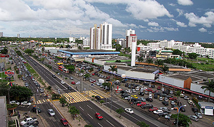
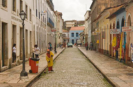 Portugal street in the historic center of São Luis, the city's UNESCO World Heritage Site Image: UNESCO © M & G Therin-Weise The city is situated on São Luís peninsula between San Marcos Bay and Arraial Bay in the middle of Brazil's north eastern coast at the Atlantic Ocean. In the beginning of the 17th century the region of the island was 'discovered' by the French. They built a fort and named it Saint Louis. The French hardly had time to finish the fort's construction cause the settlement was conquered by Portugal, only to be invaded short after by the Dutch, who left three years later in 1645, because there was nothing to gain, neither gold nor silver, only some locals who made increasingly efforts to eat them. Eventually the Portuguese took over the place again, but the city's growth was hampered for 200 more years until the American Civil War (1861-1865) caused a short supply of cotton and the region started to provide cotton to Europe. The cotton trade generated wealth and the city prospered until the end of the 19th century when agriculture started to decline. Thanks to the following period of economic stagnation in the early 20th century, São Luís has the largest and best preserved heritage of colonial Portuguese architecture of all Latin America. Today the city has a population of 1 million people. The largest city in Maranhão state lies in a tropical monsoon climate zone with a wet season from December to July, and a dry season from August to November. Annual average temperatures are around 25° C. The Map shows a city map of São Luís with expressways, main roads and streets. Zoom out to find the location of São Luís International Airport named Marechal Cunha Machado International Airport (IATA Code: SLZ) located about 8.5 km (5 mi) from São Luís city center. To find a location use the form below. |
|
| To find a location type: street or place, city, optional: state, country. |
Local Time São Luís:
Saturday-July-11 00:11
Amazon Time (AMT): UTC/GMT -5 hours |
|
φ Latitude, λ Longitude (of Map center; move the map to see coordinates): , |
||||||
| Google Earth: Searchable map/satellite view of the City of São Luís, Maranhão, Brazil. |
Bookmark/share this page |
|||||
| City Coordinates: 2°31′42″S 44°18′16″W |
||||||
| More about Brazil: Cities - background notes and a searchable map/satellite view of other Brazilian cities: Largest cities in Brazil: Other Cities: Aracaju, Belém, Boa Vista, Campo Grande, Cuiabá, Florianópolis, Goiânia, João Pessoa, Macapá, Maceió, Natal, Palmas, Porto Alegre, Porto Velho, Recife, Rio Branco, São Paulo, Teresina, Vitória Country: Continent: |
Weather Conditions São Luís
External Links São Luís (official website) Wikipedia: São Luís Wikipedia entry: São Luís |
Explore more:
Related Consumer Information:
|
||||
Other Cities in South America: Asunción (Paraguay) - Bogotá D.C. (Colombia) - Buenos Aires (Argentina) - Caracas (Venezuela) - Cayenne, Kourou (both French Guiana) - Georgetown (Guyana) - La Paz, Sucre (both Bolivia) - Lima (Peru) - Montevideo (Uruguay) - Paramaribo (Suriname) - Quito (Ecuador) - Santiago (Chile) |
||
Map Help [ show ] |
||
One World - Nations Online .:. let's care for this planet Promote that every nation assumes responsibility for our world. Nations Online Project is made to improve cross-cultural understanding and global awareness. More signal - less NOISE |
| Site Map
| Information Sources | Disclaimer | Copyright © 1998-2024:: nationsonline.org |