Nations Online
All Countries in the World
Nations Online All Countries in the World | |
Home  |
___ Satellite View and Map of the City of Fortaleza - Ceará |
About the City of Fortaleza Satellite view showing Fortaleza, a seaport and the capital of Ceará, one of the 26 Brazilian states. The city is located in the northeastern part of the country, on the Atlantic coast, it is the 5th largest city in Brazil (in 2010). Satellite view showing Fortaleza, a seaport and the capital of Ceará, one of the 26 Brazilian states. The city is located in the northeastern part of the country, on the Atlantic coast, it is the 5th largest city in Brazil (in 2010). 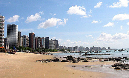 The beach and Fortaleza skyline at Mucuripe, one of the city's urban quarters. Fortaleza has about 25 km (16 mi) of urban beaches. Image: GFDL The city is located in a tropical zone and has typically a tropical wet and dry climate with high temperatures and high relative humidity throughout the year. Because of its urban beaches, Fortaleza is a major tourist destination particularly for Brazilians but also increasingly for tourists from other countries. 2014 FIFA World Cup The city was one of the twelve host cities of the 2014 FIFA World Cup. Four group matches were held at the Castelão stadium (official name: Estádio Plácido Aderaldo Castelo). The Map shows a city map of Fortaleza with expressways, main roads and streets, and the location of Fortaleza International Airport known as Pinto Martins Airport (IATA Code: FOR) located 10 km (6 mi) south of the city center. To find a location use the form below. (Map Help) |
|
| To find a location type: street or place, city, optional: state, country. |
Local Time Fortaleza:
Thursday-June-18 14:55
Brazil Standard Time: UTC/GMT -3 hoursDaylight Saving Time starts on the 3rd Sunday of October and ends on the 3rd Sunday of February shifts time offset to UTC/GMT -2 hours. |
|
φ Latitude, λ Longitude (of Map center; move the map to see coordinates): , |
||||||
| Google Earth: Searchable map/satellite view of the City of Fortaleza, Ceará, Brazil. City Coordinates: 3°43′6″S 38°32′34″W |
Bookmark/share this page |
|||||
| More about Brazil: Cities - background notes and a searchable map/satellite view of other Brazilian cities: Largest cities in Brazil: Other Cities: Aracaju, Belém, Boa Vista, Campo Grande, Cuiabá, Florianópolis, Goiânia, João Pessoa, Macapá, Maceió, Natal, Palmas, Porto Alegre, Porto Velho, Recife, Rio Branco, São Luís, São Paulo, Teresina, Vitória Country: Continent: External Links: Fortaleza (official website) Wikipedia: Fortaleza Wikipedia entry: Fortaleza |
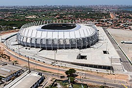 Castelão stadium in Fortaleza. Image: Brazilian Government Weather Conditions Fortaleza
|
Explore more:
Related Consumer Information:
|
||||
| Other Cities in South America: Asunción (Paraguay) - Bogotá D.C. (Colombia) - Brasilia, Rio de Janeiro, São Paulo, Salvador, (all Brazil) - Buenos Aires (Argentina) - Caracas (Venezuela) - Cayenne, Kourou (both French Guiana) - Georgetown (Guyana) - La Paz, Sucre (both Bolivia) - Lima (Peru) - Montevideo (Uruguay) - Paramaribo (Suriname) - Quito (Ecuador) - Santiago (Chile) |
||
Map Help [ show ] |
||
One World - Nations Online .:. let's care for this planet Promote that every nation assumes responsibility for our world. Nations Online Project is made to improve cross-cultural understanding and global awareness. More signal - less NOISE |
| Site Map
| Information Sources | Disclaimer | Copyright © 1998-2024:: nationsonline.org |

