
| Home |
|
|
|
___ Political Map of Paraguay | |
About Paraguay |
|
| Paraguay is a landlocked country in central South America, it is bordered by Argentina, Bolivia, and Brazil. The Pilcomayo river, a tributary of the Paraguay river, they both form parts of the eastern border with Argentina. The Paraguay river and the Apa river forms part of the border between Paraguay and Brazil. Parts of the western and southern borders are defined by the Paraná river, the second longest river in South America (the longest is the Amazon River). The Río Paraguay (Paraguay river) divides Paraguay into two different regions, the eastern region, with grassy plains and wooded hills in Eastern Paraguay (Paraguay Oriental) known as the Paraná region; and the western region, officially called Western Paraguay (Paraguay Occidental), a sparsely populated, hot and semi-arid lowland region with marshy plains near the river, and dry forest and thorny scrub elsewhere, the region is also known as the Paraguayan Chaco, part of the Gran Chaco, the sparsely populated lowland region of the Río de la Plata basin. Paraguay's highest point is Cerro Pero (Cerro Tres Kandú) with an elevation of 842 m. Paraguay occupies an area of 406,752 km² it is slightly larger than 1.5 times the size of the United Kingdom or slightly smaller than the U.S. state of California. The country has a population of 6.8 million people (official estimates 2014); capital city is Asunciòn, largest metropolitan area is Gran Asunción a conglomerate of several smaller cities around Asunciòn. Spoken languages are Spanish (official) and Guarani. |
 Bookmark/share this page |
 One World - Nations Online All Countries of the World |
|
|
||
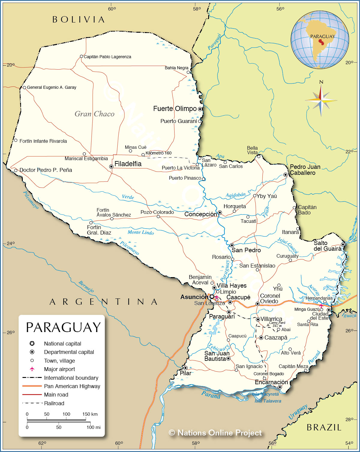 Political Map of Paraguay Map based on a UN map. Source: UN Cartographic Section |
|||||||
| Cities and towns in Paraguay The map shows the location of following cities and towns in Paraguay: Largest cities are: Asunciòn Capital District (512,000), second largest city is Ciudad del Este, capital of Alto Paraná department (320,000); following cities are part of Gran Asunciónmetropolitan area: San Lorenzo (204,000), Luque (171,000), Capiatá (154,000), Lambaré (118,000), Fernando de la Mora (114,000), Limpio (73,000), Ñemby (72,000) Encarnación (67,000), Alonso (65,000), Villa Elisa (53,000), and Itauguá (46,000). Other cities: Pedro Juan Caballero (65,000), Caaguazú (49,000), Coronel Oviedo (49,000), Hernandarias (47,000), Presidente Franco (47,000), Concepción (44,000), Villarrica (39,000) Other cities and towns: Abaí, Alto Verá, Asunción, Bahía Negra, Bella Vista, Benjamín Aceval, Caacupé, Caapucú, Caazapá, Capitán Bado, Capitán Meza, Capitán Pablo Lagerenza, Coronel Bogado, Curuguaty, Doctor Pedro P. Peña, Encarnación, Filadelfia, Fortín General Díaz, Fortín Infante Rivarola, Fortín Ávalos Sánchez, Fuerte Olimpo, General Eugenio A. Garay, Horqueta, Itanara, Kilómetró 160, Mariscal Estigarribia, Minas Cué, Minga Guazú, Paraguarí, Pilar, Pozo Colorado, Puerto Guarani, Puerto La Victoria, Puerto Pinasco, Rosario, Salto del Guairá, San Carlos, San Estanislao, San Ignacio, San Juan Bautista, San Lázaro, San Pedro, Santa Rita, Tacuatí, Villa Hayes, Villarrica, Yby Yaú, and Yhú. |
More about Paraguay Cities: Country: Continent: |
Asunción Weather Conditions:
|
Related Consumer Information:
|
||||
| Maps of other Countries in South America: Argentina Map, Brazil Map, Bolivia Map, Chile Map, Colombia Map, Ecuador Map, French Guiana Map, Guyana Map, Peru Map, Suriname Map, Uruguay Map, Venezuela Map Maps of Countries in Central America: Belize Map, Costa Rica Map, El Salvador Map, Guatemala Map, Honduras Map, Nicaragua Map, Panama Map |
|||
One World - Nations Online .:. let's care for this planet Every nation is responsible for the current state of our world. |
| Site Map
| Information Sources | Disclaimer: Privacy Policy, etc. Contact: [email protected] | Copyright © 1998-2021 :: nationsonline.org |
