Nations Online
All Countries in the World
Nations Online All Countries in the World | |
Home  |
___ Satellite View and Map of the City of Salvador - Bahia |
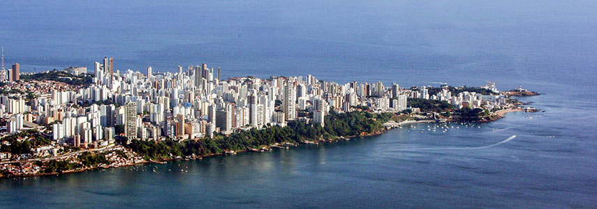 Barra neighborhood in the south zone of the city of Salvador, a peninsula between Baía de Todos os Santos (All Saints Bay, in foreground) and the Atlantic Ocean. Foto: Manu Dias/AGECOM |
About the City of Salvador
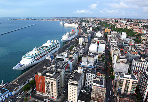 Cruise ships in Salvador's harbor (Porto de Salvador) near Centro Histórico and the Elevador Lacerda. Image: Manu Dias/AGECM The city is located in central east Brazil on the Atlantic coast at the northern end of Baía de Todos os Santos, the largest bay in Bahia. Salvador da Bahia is one of the oldest cities in the Americas. It was the first Portuguese colonial capital in Brazil, the foundation work started in 1549 under Thomé de Souza. For a long time the city was just known as Bahia. Today it is Brazil's 3rd largest city and has a population of about 2.7 million people, 3.8 million live in the metropolitan area (in 2010). The city is a major tourist attraction especially around Carnival, a popular street event is offering the biggest party in the world with people in fantastic costumes dancing to the rhythm of Axé and Samba-reggae. Salvador lies in a zone with a tropical rainforest climate, maintaining a warm and humid environment with average temperatures of 25° C throughout the year. Salvador points of interest: 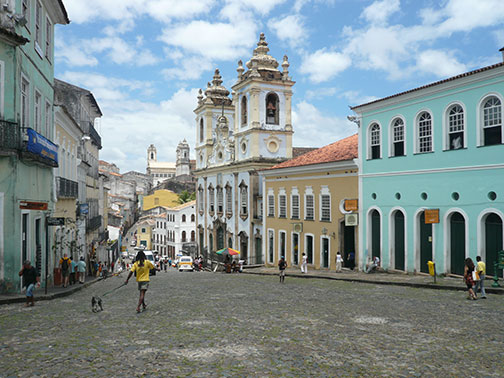 The Historic Center of Salvador (Pelourinho) Photo: Francesco Bandarin The Historic Centre of Salvador de Bahia Carnival: Bahian Carnival (annual carnival festival celebrated in Bahia, Campo Grande track (in the upper part of the city), Barra-Ondina track (by the shore), and Pelourinho (the historical neighborhood)) Beaches: Porto da Barra Beach (beach at the entrance of the Baía de Todos os Santos, small and usually crowded), Rio Vermelho (beach neighborhood with many bars and restaurants), Ponta de Humaita (ideal place for a Bahia sunset, unfortunately in an unsafe area after dark [sic!]) Museums: Museu de Arte Moderna da Bahia - MAM (small art museum with temporary exhibitions, a permanent exhibition and a restaurant-cafe with a beautiful view), Museu Rodin Bahia (shows works of Auguste Rodin or copies of them) Churches: Church of Nosso Senhor do Bonfim (the most famous of the Catholic churches of Salvador), Cathedral of Salvador (17th century cathedral, seat of the Archbishop of Salvador), São Francisco Church and Convent (important colonial monuments in the historical center of the city) Sports: Fonte Nova Arena (Itaipava Arena Fonte Nova, football stadium), Barradão (multi-purpose stadium) FIFA World Cup The city was one of the twelve host cities of the 2014 FIFA World Cup. Six group matches including the Quarter-finals were held at the Arena Fonte Nova (official name: Itaipava Arena Fonte Nova). The Map shows map of the city of Salvador with expressways, main roads and streets. Zoom out to find the location of Salvador International Airport (IATA Code: SSA) known as Luís Eduardo Magalhães International Airport, located 10 km (6 mi) south of the city center. To find a location use the form below. |
|
| To find a location type: street or place, city, optional: state, country. |
Local Time Salvador:
Tuesday-July-21 02:25
Brazil Standard Time: UTC/GMT -3 hoursDaylight Saving Time starts on the 3rd Sunday of October and ends on the 3rd Sunday of February shifts time offset to UTC/GMT -2 hours. |
|
φ Latitude, λ Longitude (of Map center; move the map to see coordinates): , |
||||||
| Google Earth: Searchable map/satellite view of the City of Salvador, Bahia, Brazil. City Coordinates: 12°58′29″S 38°28′36″W |
Bookmark/share this page |
|||||
| More about Brazil: Cities - background notes and a searchable map/satellite view of other Brazilian cities: Largest cities in Brazil: Other Cities: Aracaju, Belém, Boa Vista, Campo Grande, Cuiabá, Florianópolis, Goiânia, João Pessoa, Macapá, Maceió, Natal, Palmas, Porto Alegre, Porto Velho, Recife, Rio Branco, São Luís, São Paulo, Teresina, Vitória Country: Continent: External Links Salvador (official website) Wikipedia: Salvador Wikipedia entry: Salvador |
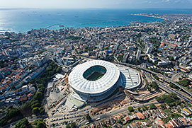 Itaipava Arena Fonte Nova (new fountain) in Salvador da Bahia. Image: Brazilian Government Weather Conditions Salvador
|
Explore more:
Related Consumer Information:
|
||||
Other Cities in South America: Asunción (Paraguay) - Bogotá D.C. (Colombia) - Buenos Aires (Argentina) - Caracas (Venezuela) - Cayenne, Kourou (both French Guiana) - Georgetown (Guyana) - La Paz, Sucre (both Bolivia) - Lima (Peru) - Montevideo (Uruguay) - Paramaribo (Suriname) - Quito (Ecuador) - Santiago (Chile) |
||
Map Help [ show ] |
||
One World - Nations Online .:. let's care for this planet Promote that every nation assumes responsibility for our world. Nations Online Project is made to improve cross-cultural understanding and global awareness. More signal - less NOISE |
| Site Map
| Information Sources | Disclaimer | Copyright © 1998-2024:: nationsonline.org |

