Nations Online
All Countries in the World
Nations Online All Countries in the World | |
Home  |
___ Searchable Map and Satellite View of Peru |
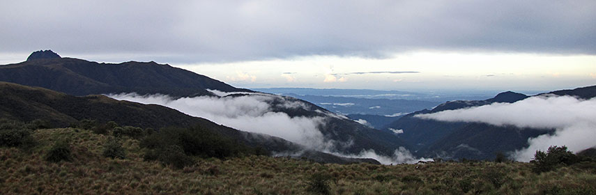 Manu National Park, located in Madre de Dios and Paucartambo, north of Cusco. The Park seen from its highest point, into the Amazon basin below. The biological diversity found in Manú National Park exceeds that of any other place on Earth. The park is a UNESCO World Heritage Site. Image: © Marc Patry |
About PeruMap is showing the third largest country in South America, with a 2400 km long coastline at the South Pacific Ocean (What a beach). Countries with international borders to Peru are Bolivia, Brazil, Chile, Colombia, and Ecuador.The country extends along the Andes, the world's longest exposed mountain range. Peru is divided in three main regions: the coast (costa), the narrow coastal plains between the Ocean and the Andes, the highlands (sierra), with the Andes mountain range and the Andean Plateau (Altiplano, average height about 3,700 m) and the highest peak in the country, the 6,768 m (22,205 ft.) Mount Huascarán, and the jungle (selva), the vast plain to the east on the other side of the Andes is covered by the Amazon rainforest. Capital and largest city is Lima. Peru has a population of more than 31 million inhabitants (in 2015). Principal languages are Spanish, Quechua, and Aymara. The map shows Peru with cities, towns, main roads and streets. To find a location use the form below. |
|
| To find a location type: street or place, city, optional: state, country. |
Local Time Peru:
Tuesday-June-30 01:46
UTC/GMT -5 hours |
|
φ Latitude, λ Longitude (of Map center; move the map to see coordinates): , |
||||||
| Google Maps: Searchable map/satellite view of the Republic of Peru. Some Points of interest: Amazon rainforest, Andes mountains, Machu Picchu, Sacred Valley, Nazca Lines, Lake Titicaca, Cusco, Lima, Huacachina oasis, Chan Chan (Pre-Columbian city), and Colca Canyon. |
Bookmark/share this page |
|||||
| More about Peru: Cities: Country: Continent: |
Current Weather Conditions Lima
|
Related Consumer Information:
|
||||
| Searchable Maps of other Countries in South America: Argentina, Brazil, Bolivia, Chile, Colombia, Ecuador, French Guiana Guyana, Paraguay, Peru, Suriname, Uruguay, Venezuela Maps of other Countries in South America: Argentina Map, Brazil Map, Bolivia Map, Chile Map, Colombia Map, Ecuador Map, French Guiana Map, Guyana Map, Paraguay Map, Peru Map, Suriname Map, Uruguay Map, Venezuela Map Countries and Territories of The Americas |
||||||
Map Help [ show ] |
||||||
One World - Nations Online .:. let's care for this planet Promote that every nation assumes responsibility for our world. Nations Online Project is made to improve cross-cultural understanding and global awareness. More signal - less NOISE |
| Site Map
| Information Sources | Disclaimer | Copyright © 1998-2024:: nationsonline.org |

