
| Home |
|
|
|
___ Administrative Map of Peru |
|
About Peru |
|
| Map is showing the western South American country with a 2,414 km long coastline at the South Pacific Ocean. Peru is bordered by Bolivia, Brazil, Chile, Colombia, and Ecuador. The third-largest country in South America occupies area of 1,285,216 km², that is more than twice the size of metropolitan France, or slightly smaller than Alaska. The country is crossed throughout its length by the Andes, the world's longest exposed mountain range. Peru's highest point is Nevado Huascaran in the Cordillera Blanca range of the western Andes, with an elevation of 6,768 m. The mountain is named after a 16th-century Inca emperor (Huáscar). Peru's three main regions are: the coast (costa), the narrow coastal plains between the Ocean and the Andes, the highlands (sierra), with the Andes range and the Andean Plateau (Altiplano) with an average height of about 3,700 m, and, more than half of the country's area is jungle (selva), a vast flat region in the east, covered by the Amazon rainforest. Peru has a population of about 31.1 million inhabitants (in 2015). Capital and largest city is Lima. Official languages are Spanish and Quechua, a native language, spoken primarily in the Andes region. Map is showing Peru and the surrounding countries with international borders, provincial boundaries, the national capital Lima, provincial capitals, major cities, main roads, railroads and major airports. |
 Bookmark/share this page |
 One World - Nations Online All Countries of the World |
|
|
||
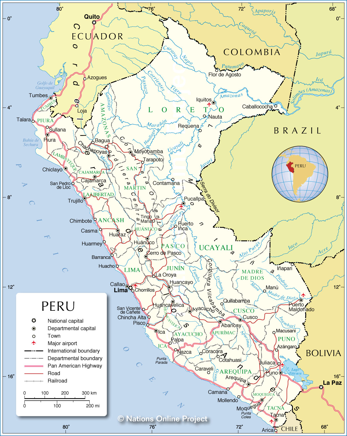 Administrative Map of Peru Map based on a UN map. Source: UN Cartographic Section |
|||||||
| Cities and Towns in Peru Map shows the location of following Peruvian cities and towns (ordered by size): Lima (8.5 million), Arequipa (800,000), Trujillo (780,000), Chiclayo (530,000), Piura (421,000), Iquitos (360,000), Cusco (350,000), Huancayo (336,000), Chimbote (320,000), Pucallpa (270,000), Tacna, Ica, Juliaca, Sullana, Cajamarca, Chincha Alta, Ayacucho, Huánuco, Huacho, Puno, Tarapoto, Huaraz, Tumbes, Talara, Huaral, Paita, Jaén, Cerro de Pasco, Ilo, Puerto Maldonado, Chulucanas, Pisco, Barranca, Moquegua, Abancay, Tingo María, Yurimaguas, Lambayeque, Chancay, Tarma, Moyobamba, Sicuani, Chepén, Huancavelica, Cañete, Virú, La Union, Imperial, Guadalupe, Sechura, Ferreñafe, La Arena, Huamachuco, Bagua Grande, Nueva Cajamarca, Casa Grande, Huanta, Perené, Andahuaylas, Huaura, Quillabamba, Pichanaqui, Pacasmayo, Mala, Bagua, Tumán, Casma, Majes, Espinar, Marcavelica, Juanjuí, Nazca, Chachapoyas, Mollendo, Monsefú, Ilave, Requena, Querecotillo, Satipo, and Chanchamayo. |
More about Peru Key statistic figures Peru. |
Lima Current Weather Conditions
|
Related Consumer Information:
|
||||
| Maps of other Countries in South America: Argentina Map, Brazil Map, Bolivia Map, Chile Map, Colombia Map, Ecuador Map, French Guiana Map, Guyana Map, Paraguay Map, Suriname Map, Uruguay Map, Venezuela Map Maps of Countries in Central America: Belize Map, Costa Rica Map, El Salvador Map, Guatemala Map, Honduras Map, Nicaragua Map, Panama Map |
|||
One World - Nations Online .:. let's care for this planet Every nation is responsible for the current state of our world. |
| Site Map
| Information Sources | Disclaimer: Privacy Policy, etc. Contact: [email protected] | Copyright © 1998-2021 :: nationsonline.org |
