
| Home |
|
|
|
___ Map of Uruguay (Oriental Republic of Uruguay) |
|
About Uruguay |
|
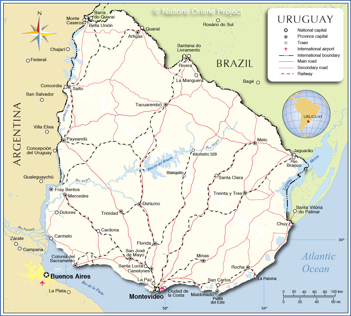
Uruguay is a country on the Atlantic coast of South America south of Brazil, it borders Argentina in west. With an area of 176,000 km², the country is the second-smallest nation in South America, but still almost twice the size of Portugal or slightly smaller than the U.S. state of Washington. Uruguay has a population of 3.25 million inhabitants (2011 census) of whom 1.3 million live in the capital and largest Montevideo. Official language is Spanish. The topography of the Oriental Republic of Uruguay is the transition of the landscape between the Argentine plains in west to the hilly lands of southern Brazil. Flat plains are found along the country’s eastern, southern, and western borders, while the interior consists of rolling plains and hills. The country's highest point is Cerro Catedral with just 514 m. Uruguay's Atlantic coast with its number of shallow lagoon inlets, is marshy and sandy, whereas the coasts of the Rio de la Plata and the Rio Uruguay are less wet and broader. Uruguay’s most valuable resource is water. The country has a number of rivers and some sizable lakes situated in its interior. The largest is a dam lake named Embalse del Río Negro (Black River reservoir) also known as Rincón del Bonete, the lake is fed by Rio Negro, creating the largest artificial lake in South America. Rio Negro is the country's primary river, it runs from north east to west, where it flows into Rio Uruguay (Uruguay river), which forms the border with Argentina. The map is showing Uruguay and the neighboring countries with international borders, the national capital Montevideo, department capitals, major cities and towns, main roads, railroads and major airports. |
 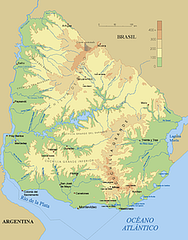 Uruguay relief map, showing the country's plains, hills, lakes and rivers. Bookmark/share this page |
 One World - Nations Online all countries of the world |
|
|
||
 Map of Uruguay |
|||||||
| Cities in Uruguay The map shows the location of Uruguay's cities and towns: Largest cities in Uruguay: Montevideo (capital, largest city and primary port ; pop.: 1.3 million), Salto (second largest city; pop.: 100,000), Ciudad de la Costa (pop.: 83,000), Paysandú (pop.: 74,000) Other cities, towns, and places: Artigas, Bella Unión, Blanquillo, Canelones, Cardona, Carmelo, Chuy, Colonia del Sacramento, Dolores, Durazno, Florida, Fray Bentos, Kilometro 329, La Manguera, La Paloma, La Paz, Maldonado, Melo, Mercedes, Minas, Punta del Este, Rio Branco, Rivera, Rocha, San Carlos, San José de Mayo, Santa Clara, Santa Lucía, Tacuarembó, Treinta y Tres, and Trinidad. |
More about Uruguay: Cities: Country: Continent: |
Current Weather Conditions Montevideo: Weather station is at Carrasco International Airport.
|
Related Consumer Information:
|
||||
| Maps of other Countries in South America: Argentina Map, Brazil Map, Bolivia Map, Chile Map, Colombia Map, Ecuador Map, French Guiana Map, Guyana Map, Paraguay Map, Peru Map, Suriname Map, Venezuela Map Maps of Countries in Central America: Costa Rica Map, El Salvador Map, Guatemala Map, Honduras Map, Mexico Map, Nicaragua Map, Panama Map Maps of Caribbean Islands Cuba Map, Dominican Republic Map, Haiti Map, Jamaica Map, Puerto Rico Map | |||||||
One World - Nations Online .:. let's care for this planet Every nation is responsible for the current state of our world. |
| Site Map
| Information Sources | Disclaimer: Privacy Policy, etc. Contact: [email protected] | Copyright © 1998-2021 :: nationsonline.org |
