Nations Online
All Countries in the World
Nations Online All Countries in the World | |
Home  |
___ Satellite View and Map of the City of Belo Horizonte - Minas Gerais |
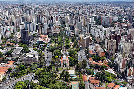
About the City of Belo Horizonte Satellite view showing Belo Horizonte, located in the southeastern region of Satellite view showing Belo Horizonte, located in the southeastern region of The city is built on several hills and is framed by the Serra do Curral mountain range. It was the first planned city in the country to replace Ouro Preto as the capital. In December 1897 it became the capital of MG, named Cidade de Minas (Minas City), it was renamed Belo Horizonte (lit. "Beautiful Horizon") in 1901. Today the city has a population of about 2.5 million people, more than 5 million live in its metropolitan region "Greater Belo Horizonte". BH is the sixth most populous city in Brazil. 2014 FIFA World Cup The city was one of the twelve host cities of the 2014 FIFA World Cup. Six matches including the Semi-finals were held at the Mineirão stadium, the largest football stadium in the state of Minas Gerais (official name: Estádio Governador Magalhães Pinto). The Map shows a city map of Belo Horizonte with expressways, main roads and streets, and the location of Belo Horizonte Airport known as Pampulha Airport (IATA Code: PLU) and Carlos Prates Airport (IATA Code: none) Zoom out to find Tancredo Neves International Airport (IATA Code: CNF). Belo Horizonte’s main airport is situated about 40 km (25 mi) north of the city in the municipalities of Confins and Lagoa Santa. To find a location use the form below. (Map Help) |
|
| To find a location type: street or place, city, optional: state, country. |
Local Time Belo Horizonte:
Friday-July-17 16:40
Brasília Time Zone (BRT): UTC/GMT -3 hoursDaylight Saving Time starts on the 3rd Sunday of October and ends on the 3rd Sunday of February shifts time offset to UTC/GMT -2 hours. |
|
φ Latitude, λ Longitude (of Map center; move the map to see coordinates): , |
||||||
| Google Earth: Searchable map/satellite view of the City of Belo Horizonte, Minas Gerais, Brazil. City Coordinates: 19°55′S 43°56′W |
Bookmark/share this page |
|||||
| More about Brazil: Cities - background notes and a searchable map/satellite view of other Brazilian cities: Largest cities in Brazil: Other Cities: Aracaju, Belém, Boa Vista, Campo Grande, Cuiabá, Florianópolis, Goiânia, João Pessoa, Macapá, Maceió, Natal, Palmas, Porto Alegre, Porto Velho, Recife, Rio Branco, São Luís, São Paulo, Teresina, Vitória Country: Continent: External Links: Belo Horizonte (official website) VisitBH Official tourism website of Belo Horizonte Wikipedia: Belo Horizonte Wikipedia entry: Belo Horizonte |
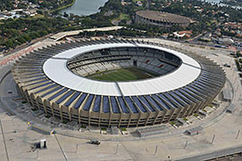 The Mineirão Stadium, Belo Horizonte Image: Brazilian Government Weather Conditions Belo Horizonte
|
Explore more:
Related Consumer Information:
|
||||
Other Cities in South America: Asunción (Paraguay) - Bogotá D.C. (Colombia) - Brasilia, Rio de Janeiro, São Paulo, Salvador, (all Brazil) - Buenos Aires (Argentina) - Caracas (Venezuela) - Cayenne, Kourou (both French Guiana) - Georgetown (Guyana) - La Paz, Sucre (both Bolivia) - Lima (Peru) - Montevideo (Uruguay) - Paramaribo (Suriname) - Quito (Ecuador) - Santiago (Chile) |
||
Map Help [ show ] |
||
One World - Nations Online .:. let's care for this planet Promote that every nation assumes responsibility for our world. Nations Online Project is made to improve cross-cultural understanding and global awareness. More signal - less NOISE |
| Site Map
| Information Sources | Disclaimer | Copyright © 1998-2024:: nationsonline.org |