Nations Online
All Countries in the World
Nations Online All Countries in the World | |
Home  |
___ Satellite View and Map of the City of Teresina - Piauí |
About the City of Teresina Satellite view showing Teresina, largest city and capital of Piauí, one of the 26 Brazilian states. The city is located in Satellite view showing Teresina, largest city and capital of Piauí, one of the 26 Brazilian states. The city is located in 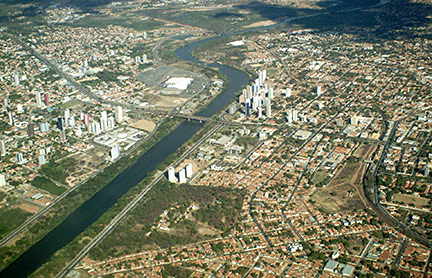 Aerial view of Teresina central business district with Poti River. Image: Isaac Maia Today the city has a population of about 840,000 (est. 2013) with the adjacent city of Timon in Brazil 's Maranhão state, Teresina forms a conurbation (metropolitan area) with more than 1 million people. The city is the main economic and financial center of Piauí state, its economy is based on manufacturing industries and trade. Teresina lies in a tropical wet and dry climate zone with a rainy season in from January to May. Average temperatures are 26° Celsius throughout the year. The Map shows map of the city of Teresina with expressways, main roads and streets and the location of Teresina International Airport (IATA Code: THE) named Teresina/Senador Petrônio Portella Airport, about 5 km (3 mi) from Teresina's city center. To find a location use the form below. (Map Help) |
|
| To find a location type: street or place, city, optional: state, country. |
Local Time Teresina:
Thursday-July-23 15:08
Time zone: Brasilia Time (BRT): UTC/GMT -3 hoursDaylight Saving Time starts on the 3rd Sunday of October and ends on the 3rd Sunday of February shifts time offset to UTC/GMT -2 hours. |
|
φ Latitude, λ Longitude (of Map center; move the map to see coordinates): , |
||||||
| Google Earth: Searchable map/satellite view of the City of Teresina, Piauí, Brazil. City Coordinates: 5°5′21″S 42°48′6″W |
Bookmark/share this page |
|||||
| More about Brazil: Cities - background notes and a searchable map/satellite view of other Brazilian cities: Largest cities in Brazil: Other Cities: Aracaju, Belém, Boa Vista, Campo Grande, Cuiabá, Florianópolis, Goiânia, João Pessoa, Macapá, Maceió, Natal, Palmas, Porto Alegre, Porto Velho, Recife, Rio Branco, São Luís, São Paulo, Vitória Country: Continent: |
Current Weather Conditions Teresina
External Links: Teresina (official website, in Portuguese) Tourismo Teresina Official tourism website (in Portuguese) Wikipedia: Teresina Wikipedia entry: Teresina |
Explore more:
Related Consumer Information:
|
||||
Other Cities in South America: Asunción (Paraguay) - Bogotá D.C. (Colombia) - Buenos Aires (Argentina) - Caracas (Venezuela) - Cayenne, Kourou (both French Guiana) - Georgetown (Guyana) - La Paz, Sucre (both Bolivia) - Lima (Peru) - Montevideo (Uruguay) - Paramaribo (Suriname) - Quito (Ecuador) - Santiago (Chile) |
||
Map Help [ show ] |
||
One World - Nations Online .:. let's care for this planet Promote that every nation assumes responsibility for our world. Nations Online Project is made to improve cross-cultural understanding and global awareness. More signal - less NOISE |
| Site Map
| Information Sources | Disclaimer | Copyright © 1998-2024:: nationsonline.org |

