Nations Online
All Countries in the World
Nations Online All Countries in the World | |
| Home |
___ Political Map of Chile |
| Chile is a country that occupies a long coastal strip that runs down the western coast of South America, on the Pacific Ocean. It is bordered by Argentina and Bolivia in east and Peru in north. The country has an area of 756,102 km², compared it is slightly smaller than Turkey or slightly smaller than twice the size of the U.S. state of Montana. The Republic of Chile (official name) has a population of 17.8 million people (official estimates 2014). Capital and largest city is Santiago (Santiago de Chile). National language is Spanish. The detailed map below is showing is the country with international borders, the national capital Santiago (de Chile), region capitals, cities, main roads, railroads and major airports. |
||||||
| Bookmark/share this page |
||||||
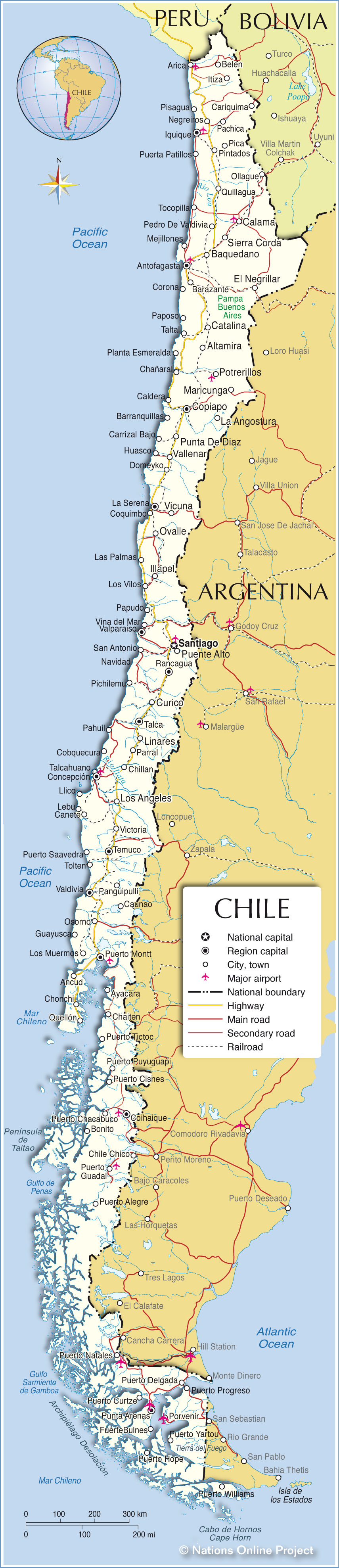 Political Map of Chile The map shows the location of following Chilean cities and towns: Largest cities with more than 200,000 inhabitants are: Santiago Metropolis, Santiago Metropolitan Region (5,900,000); Greater Concepción, Bío Bío Region (949,000); Greater Valparaíso, Valparaíso Region (935,000); Greater La Serena, Coquimbo Region (414,000); Antofagasta, Antofagasta Region (349,000); Greater Temuco, Araucanía Region (345,000); Greater Iquique, Tarapacá Region (279,000); Rancagua conurbation, O'Higgins Region (277,000); Puerto Montt, Los Lagos Region (238,000); and Arica, Arica y Parinacota Region (211,000) Other cities and towns in Chile: Altamira, Ancud, Ayacara, Baquedano, Barazante, Barranquillas, Belen, Bonito, Bulnes, Calama, Caldera, Canete, Cariquima, Carrizal Bajo, Catalina, Caunao, Chaiten, Chañaral, Chile Chico, Chillan, Chonchi, Cobquecura, Coihaique, Copiapo, Coquimbo, Corona, Curico, Domeyko, El Negrillar, Fuerte, Guayusca, Huasco, Illapel, Itiza, La Angostura, Las Palmas, Lebu, Linares, Llico, Los Angeles, Los Muermos, Los Vilos, Maricunga, Mejillones, Navidad, Negreiros, Ollague, Osorno, Ovalle, Pachica, Pahuil, Panguipulli, Paposo, Papudo, Parral, Pedro De Valdivia, Pica, Pichilemu, Pintados, Pisagua, Planta Esmeralda, Porvenir, Potrerillos, Puente Alto, Puerta Patillos, Puerto Alegre, Puerto Chacabuco, Puerto Cisnes, Puerto Curtze, Puerto Delgada, Puerto Guadal, Puerto Hope, Puerto Natales, Puerto Progreso, Puerto Puyuguapi, Puerto Saavedra, Puerto Tictoc, Puerto Williams, Puerto Yartou, Punta Arenas, Punta De Diaz, Quellón, Quillagua, San Antonio ,Sierra Corda, Talca, Talcahuano, Taltal, Tocopilla, Tolten, Valdivia, Vallenar, Victoria, Vicuna, and Vina del Mar. Map based on a UN map. Source: UN Cartographic Section |
||||||
| More about Chile: Country: Chile key statistical data. Continent: |
Weather Conditions Santiago de Chile:
|
Related Consumer Information: |
||||
| Maps of other Countries in South America: Argentina Map, Brazil Map, Bolivia Map, Colombia Map, Ecuador Map, French Guiana Map, Guyana Map, Paraguay Map, Peru Map, Suriname Map, Uruguay Map, Venezuela Map Maps of Countries in Central America: Belize Map, Costa Rica Map, El Salvador Map, Guatemala Map, Honduras Map, Nicaragua Map, Panama Map |
One World - Nations Online .:. let's care for this planet Promote that every nation assumes responsibility for our world. Nations Online Project is made to improve cross-cultural understanding and global awareness. More signal - less NOISE |
| Site Map
| Information Sources | Disclaimer | Copyright © 1998-2024:: nationsonline.org |
