Nations Online
All Countries in the World
Nations Online All Countries in the World | |
Home  |
___ Satellite View and Map of the City of Curitiba - Paraná |
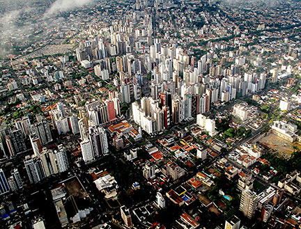
About the City of Curitiba Satellite view showing Curitiba, the capital of Paraná, the second largest of the 26 Brazilian states. The city is located in the South Region of Satellite view showing Curitiba, the capital of Paraná, the second largest of the 26 Brazilian states. The city is located in the South Region of The story of the city begins with the foundation of the city council in 1693. But only 150 years later European immigrants from Germany, Italy, Poland and Ukraine started arriving in the mid-19th century. Today Curitiba has a population of almost 1.8 million, 3.2 million people live in the metropolitan area with its neighborhoods and boroughs (census 2010). The city is home to the Federal University of Paraná, and is also the cultural, economic, and political center of the state. The city lies in a temperate climate zone offering a warm and humid environment with average temperatures of 25° Celsius in summer, winters are mild and damp, but sometimes with cold winds. 2014 FIFA World Cup The city was one of the twelve host cities of the 2014 FIFA World Cup. Four group matches were held at the Arena da Baixada in June 2014. The Map shows map of the city of Curitiba with expressways, main roads and streets as well as the location of Bacacheri Airport (BFH), today an airport used for general aviation. Zoom out to find the location of Curitiba International Airport (IATA Code: CWB) named Afonso Pena International Airport, located in São José dos Pinhais about 17 km (11 mi) south east from Curitiba's city center. To find a location use the form below. (Map Help) |
|
| To find a location type: street or place, city, optional: state, country. |
Local Time Curitiba:
Monday-July-20 12:36
Brasília time (BRT): UTC/GMT -3 hoursBrasilia Summer Time (BRST) from mid-October to mid-February -2 hours |
|
φ Latitude, λ Longitude (of Map center; move the map to see coordinates): , |
||||||
| Google Earth: Searchable map/satellite view of the City of Curitiba, Paraná, Brazil. City Coordinates: 25°25′S 49°15′W |
Bookmark/share this page |
|||||
| More about Brazil: Cities - background notes and a searchable map/satellite view of other Brazilian cities: Largest cities in Brazil: Other Cities: Aracaju, Belém, Boa Vista, Campo Grande, Cuiabá, Florianópolis, Goiânia, João Pessoa, Macapá, Maceió, Natal, Palmas, Porto Alegre, Porto Velho, Recife, Rio Branco, São Luís, São Paulo, Teresina, Vitória Country: Continent: External Links Curitiba (official website) Curitiba Portal do Turismo (in Portuguese) Wikipyedia: Curitiba Wikipedia entry: Curitiba |
 Arena da Baixada in Curitiba. Image: Brazilian Government Current Weather Conditions Curitiba
|
Explore more:
Related Consumer Information:
|
||||
Other Cities in South America: Asunción (Paraguay) - Bogotá D.C. (Colombia) - Brasilia, Rio de Janeiro, São Paulo, Salvador, (all Brazil) - Buenos Aires (Argentina) - Caracas (Venezuela) - Cayenne, Kourou (both French Guiana) - Georgetown (Guyana) - La Paz, Sucre (both Bolivia) - Lima (Peru) - Montevideo (Uruguay) - Paramaribo (Suriname) - Quito (Ecuador) - Santiago (Chile) |
||
Map Help [ show ] |
||
One World - Nations Online .:. let's care for this planet Promote that every nation assumes responsibility for our world. Nations Online Project is made to improve cross-cultural understanding and global awareness. More signal - less NOISE |
| Site Map
| Information Sources | Disclaimer | Copyright © 1998-2024:: nationsonline.org |