Nations Online
All Countries in the World
Nations Online All Countries in the World | |
Home  |
___ Satellite View and Map of the City of Cuiabá - Mato Grosso |
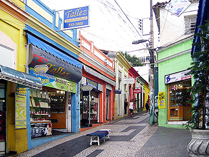
About the City of Cuiabá Satellite view showing Cuiabá, capital of Mato Grosso, one of the 26 Brazilian states and the third largest by area. A remarkable detail about the city is that it is located in the exact geographic center of South America. Satellite view showing Cuiabá, capital of Mato Grosso, one of the 26 Brazilian states and the third largest by area. A remarkable detail about the city is that it is located in the exact geographic center of South America.The city was founded in January 1727 on the north eastern bank of the Cuiabá River (Rio Cuiabá) and since 1835 it is the capital of Mato Grosso state. Today the city has a population of more than half a million people (together with the state’s second largest city Várzea Grande). Cuiabá lies in the subtropical zone and has therefore a humid subtropical climate, with the highest temperatures in December and January. The city is the trading center for a productive agricultural and cattle-raising region. It is also a gateway for people heading to the northern Pantanal, one of the world's largest and most diverse freshwater wetland ecosystems. 2014 FIFA World Cup The city was one of the twelve host cities of the 2014 FIFA World Cup. Four group matches were held at the Arena Pantanal stadium (official name: Arena Multiuso Governador José Fragelli). The Map shows a city map of Cuiabá with expressways, main roads and streets. Zoom out to find the location of Cuiabá Airport known as Marechal Rondon International Airport (IATA Code: CGB) located 7 km (4 mi) south west of the city center in the municipality of Várzea Grande. To find a location use the form below. (Map Help) |
|
| To find a location type: street or place, city, optional: state, country. |
Local Time Cuiabá:
Monday-July-13 04:00
Amazon Time (AMT): UTC/GMT -4 hoursDaylight Saving Time starts on the 3rd Sunday of October and ends on the 3rd Sunday of February shifts time offset to UTC/GMT -3 hours . |
|
φ Latitude, λ Longitude (of Map center; move the map to see coordinates): , |
||||||
| Google Earth: Searchable map/satellite view of the City of Cuiabá, Mato Grosso, Brazil. City Coordinates: 22°54′30″S 43°11′47″W |
Bookmark/share this page |
|||||
| More about Brazil: Cities - background notes and a searchable map/satellite view of other Brazilian cities: Largest cities in Brazil: Other Cities: Aracaju, Belém, Boa Vista, Campo Grande, Florianópolis, Goiânia, João Pessoa, Macapá, Maceió, Natal, Palmas, Porto Alegre, Porto Velho, Recife, Rio Branco, São Luís, São Paulo, Teresina, Vitória Country: Continent: External Links: Cuiabá (official website) Wikipedia: Cuiabá Wikipedia entry: Cuiabá 2014 FIFA World Cup Official website of The Fédération Internationale de Football Association (FIFA) |
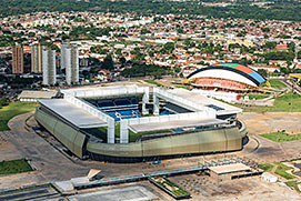 Arena Pantanal in Cuiabá, Mato Grosso. Image: Brazilian Government Current Weather Conditions Cuiabá
|
Explore more:
Related Consumer Information:
|
||||
Other Cities in South America: Asunción (Paraguay) - Bogotá D.C. (Colombia) - Brasilia, Rio de Janeiro, São Paulo, Salvador, (all Brazil) - Buenos Aires (Argentina) - Caracas (Venezuela) - Cayenne, Kourou (both French Guiana) - Georgetown (Guyana) - La Paz, Sucre (both Bolivia) - Lima (Peru) - Montevideo (Uruguay) - Paramaribo (Suriname) - Quito (Ecuador) - Santiago (Chile) |
||
Map Help [ show ] |
||
One World - Nations Online .:. let's care for this planet Promote that every nation assumes responsibility for our world. Nations Online Project is made to improve cross-cultural understanding and global awareness. More signal - less NOISE |
| Site Map
| Information Sources | Disclaimer | Copyright © 1998-2024:: nationsonline.org |