Nations Online
All Countries in the World
Nations Online All Countries in the World | |
Home  |
___ Satellite View and Map of the City of Florianópolis - Santa Catarina |
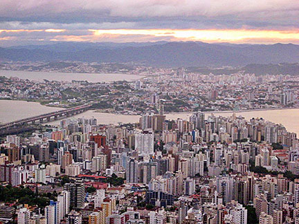
About the City of Florianópolis Satellite view showing Florianópolis, the second largest city and capital of Santa Catarina, one of the 26 Brazilian states. The city is located in Satellite view showing Florianópolis, the second largest city and capital of Santa Catarina, one of the 26 Brazilian states. The city is located in Florianópolis was a colonial settlement on Santa Catarina island in the late 17th century. With the construction of a chapel (first things first) named Nossa Senhora do Desterro in 1678 the village slowly took shape. The place was upgraded to town status in 1714 then known as Vila do Desterro (loosely rendered as: Village of Exiles). the village people were not so happy with that name but it took them until 1893 to change it into Florianópolis, named after the then president of Brazil, Marechal Floriano Peixoto. Today the city has a population of about 450,000 (est. 2013). With the adjacent municipalities, Florianópolis forms a metropolitan area, the Região Metropolitana de Florianópolis, with more than 1 million people. The city's economy is mainly based on commerce and service, but some agricultural activities still exist. But actually Florianópolis is on the brink to become the Silicon Valley of Brazil — with beaches. Florianópolis lies in a humid subtropical climate zone with a Summer season from November till May and an increased amount of precipitation from January to March. Average temperatures are friendly most of the time, between 20° and 26° Celsius. Winter might be a little cooler. The Map shows map of the city of Florianópolis with expressways, main roads and streets and the location of Florianópolis International Airport (IATA Code: FLN) named Florianópolis-Hercílio Luz International Airport, about 12.4 km (8 mi) south of the city center. To find a location use the form below. (Map Help) |
|
| To find a location type: street or place, city, optional: state, country. |
Local Time Florianópolis:
Friday-July-31 22:20
Brasília time (BRT): UTC/GMT -3 hours |
|
φ Latitude, λ Longitude (of Map center; move the map to see coordinates): , |
||||||
| Google Earth: Searchable map/satellite view of the City of Florianópolis, Santa Catarina, Brazil. City Coordinates: 27°50′S 48°25′W |
Bookmark/share this page |
|||||
| More about Brazil: Cities - information and a searchable map/satellite view of other Brazilian cities: Largest cities in Brazil: Other Cities: Aracaju, Belém, Boa Vista, Campo Grande, Cuiabá, Goiânia, João Pessoa, Macapá, Maceió, Natal, Palmas, Porto Alegre, Porto Velho, Recife, Rio Branco, São Luís, São Paulo, Teresina, Vitória Country: Continent: |
Weather Conditions Florianópolis
External Links: Florianópolis (official website, in Portuguese) Living Floripa Official tourism guide for the City of Florianópolis. Wikipedia: Florianópolis Wikipedia entry: Florianópolis |
Explore more:
Related Consumer Information:
|
||||
Other Cities in South America: Asunción (Paraguay) - Bogotá D.C. (Colombia) - Buenos Aires (Argentina) - Caracas (Venezuela) - Cayenne, Kourou (both French Guiana) - Georgetown (Guyana) - La Paz, Sucre (both Bolivia) - Lima (Peru) - Montevideo (Uruguay) - Paramaribo (Suriname) - Quito (Ecuador) - Santiago (Chile) |
||
Map Help [ show ] |
||
One World - Nations Online .:. let's care for this planet Promote that every nation assumes responsibility for our world. Nations Online Project is made to improve cross-cultural understanding and global awareness. More signal - less NOISE |
| Site Map
| Information Sources | Disclaimer | Copyright © 1998-2024:: nationsonline.org |