
| Home |
|
|
|
___ Political Map of Suriname | |
About Suriname |
|
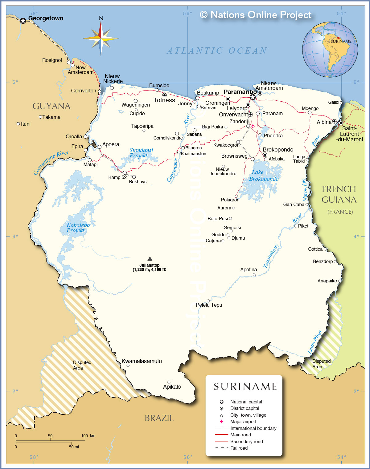
| Suriname is a country on the northeastern coast of South America. The country is bordered by the Atlantic Ocean in north, by Guyana in west, by French Guiana in east, and by Brazil in south. The western and eastern borders of Suriname are subject to longstanding disputes between the Republic of Suriname and its neighboring countries. The southern border with Brazil is uncontroversial since 1906. Colonized by the Dutch and the English from the 17th century. The country was known as Dutch Guiana until 1954, it became fully independent in 1975. With an area of 163,820 km² Suriname is about four times the size of the Netherlands (mainland), or slightly larger than the U.S. state of Georgia. The population of Suriname are largely descendents from African slaves and Asian laborers brought in to work on sugar plantations and there is also left a small American Indian population. The country has a population of today 580,000 people (2015), most of them live in the coastal regions. Capital and largest city is Paramaribo, spoken languages are Dutch (official), English (widely spoken), Sranang Tongo (a native Creole language and lingua franca), and Caribbean Hindustani. Suriname's landscape offers a narrow coastal plain dotted with swamps and marshes, the interior consists mostly of rolling hills covered by a tropical rainforest. The hilly country is rising up to the highest point in Suriname, the Julianatop, a hill with an elevation at its top of 1,230 m (4,199 ft.). The country near the Equator has a tropical rainforest climate which is moderated by trade winds at the coast. Major rivers in Suriname are the Commewijne River, the Coppename River, the Courantyne River, which forms a long part of the border with Guyana, and Marowijne (Moroni) River, which marks the (disputed) border between French Guiana and Suriname, the Litani River, a tributary of the Maroni River, forms part of the semi-official southern boundary between Suriname and French Guiana. Map is showing the South American country with international borders, the national capital Paramaribo, province capitals, major towns, villages, and resorts, main roads, and the location of the country's only international airport, Johan Adolf Pengel International Airport (IATA code: PBM) near Zanderij, and the two railway lines in Suriname, but none of them are in use. |
 Bookmark/share this page |
 One World - Nations Online All Countries of the World |
|
|
||
 Political Map of Suriname |
|||||||
| Cities and Towns in Suriname Map shows the location of following Surinamese cities, towns and villages: Afobaka, Albina, Anapaike, Apetina, Apikalo, Apoera, Aurora, Bakhuys, Batavia, Benzdorp, Bigi Poika, Bitagron, Boskamp, Boto-Pasi, Brokopondo, Brownsweg, Burnside, Cajana, Corneliskondre, Cottica, Cupido, Djumu, Gaa Caba, Galibi, Goddo, Groningen, Jenny, Kaaimanston, Kamp 52, Kwakoegron, Kwamalasamutu, Langa Tabiki, Lelydorp (second largest city; pop. ca. 16,000), Matapi, Moengo, Nieuw Amsterdam, Nieuw Jacobkondre, Nieuw Nickerie (third largest city in the country; pop. 15,000), Onverwacht, Paramaribo (capital and largest city), Paranam, Pelelu Tepu, Phaedra, Piketi, Pokigron, Sabana, Semoisi, Tapoeripa, Totness, Wageningen, and Zanderij. |
More about Suriname: Cities: Country: Continent: Historically related Countries: |
Paramaribo Current Weather Conditions, weatherstation at the International Airport near Zanderij.
|
Related Consumer Information:
|
||||
Maps of Countries in North America: Canada Map, Mexico Map, USA Map Maps of Countries in Central America: Costa Rica Map, El Salvador Map, Guatemala Map, Honduras Map, Nicaragua Map, Panama Map Maps of Caribbean Islands Cuba Map, Dominican Republic Map, Haiti Map, Jamaica Map, Puerto Rico Map Maps of other Countries in South America: Argentina Map, Brazil Map, Bolivia Map, Chile Map, Colombia Map, Ecuador Map, French Guiana Map, Guyana Map, Paraguay Map, Peru Map, Uruguay Map, Venezuela Map | |||||||
One World - Nations Online .:. let's care for this planet Every nation is responsible for the current state of our world. |
| Site Map
| Information Sources | Disclaimer: Privacy Policy, etc. Contact: [email protected] | Copyright © 1998-2021 :: nationsonline.org |
