Nations Online
All Countries in the World
Nations Online All Countries in the World | |
Home  |
___ Satellite View and Map of the City of Campo Grande - Mato Grosso do Sul |
About the City of Campo Grande Satellite view showing Campo Grande (Big Field) in the center of Mato Grosso do Sul, one of the 26 Brazilian states, which is situated in the Center-West region of Satellite view showing Campo Grande (Big Field) in the center of Mato Grosso do Sul, one of the 26 Brazilian states, which is situated in the Center-West region of 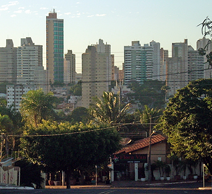 The center of Campo Grande. Image: Allexanndro Campo Grande is the main gateway to the southern Pantanal, one of the world's largest freshwater wetland ecosystems, a vast almost uninhabited region in central west of Brazil, about half the size of Germany. The Pantanal Conservation Area The largest city in Mato Grosso do Sul lies 500 m above sea level in a highland tropical climate zone with a dry winter season from June until September. Annual average temperatures are around 23° C. The city's economy is based on commerce and services, as well as on agriculture industry. It is also the center of education in the state with several universities. The Map shows a city map of Campo Grande with expressways, main roads and streets and the location of Campo Grande Airport, also known as Antônio João Airport, (IATA Code: CGR) located about 6 km (4 mi) west of Campo Grande city center. To find a location use the form below. (Map Help) |
|
| To find a location type: street or place, city, optional: state, country. |
Local Time Campo Grande:
Thursday-July-30 19:59
Amazon Time (AMT): UTC/GMT -4 hours |
|
φ Latitude, λ Longitude (of Map center; move the map to see coordinates): , |
||||||
| Google Earth: Searchable map/satellite view of the City of Campo Grande, Mato Grosso do Sul, Brazil. City Coordinates: 20°26′37″S 54°38′52″W |
Bookmark/share this page |
|||||
| More about Brazil: Cities - background notes and a searchable map/satellite view of other Brazilian cities: Largest cities in Brazil: Other Cities: Aracaju, Belém, Boa Vista, Cuiabá, Florianópolis, Goiânia, João Pessoa, Macapá, Maceió, Natal, Palmas, Porto Alegre, Porto Velho, Recife, Rio Branco, São Luís, São Paulo, Teresina, Vitória Country: Continent: |
Weather Conditions Campo Grande
External Links: Campo Grande (official website) Wikipedia: Campo Grande Wikipedia entry: Campo Grande |
Explore more:
Related Consumer Information:
|
||||
| Other Cities in South America: Asunción (Paraguay) - Bogotá D.C. (Colombia) - Brasilia, Rio de Janeiro, São Paulo, Salvador, (all Brazil) - Buenos Aires (Argentina) - Caracas (Venezuela) - Cayenne, Kourou (both French Guiana) - Georgetown (Guyana) - La Paz, Sucre (both Bolivia) - Lima (Peru) - Montevideo (Uruguay) - Paramaribo (Suriname) - Quito (Ecuador) - Santiago (Chile) |
||
Map Help [ show ] |
||
One World - Nations Online .:. let's care for this planet Promote that every nation assumes responsibility for our world. Nations Online Project is made to improve cross-cultural understanding and global awareness. More signal - less NOISE |
| Site Map
| Information Sources | Disclaimer | Copyright © 1998-2024:: nationsonline.org |

