Nations Online
All Countries in the World
Nations Online All Countries in the World | |
Home  |
___ Satellite View and Map of the City of Natal - Rio Grande do Norte |
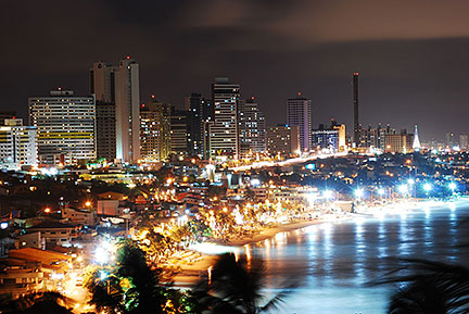
About the City of Natal Satellite view showing Natal (Portuguese for Christmas), a seaport and the capital of Rio Grande do Norte, one of the 26 Brazilian states. The city is located in east Satellite view showing Natal (Portuguese for Christmas), a seaport and the capital of Rio Grande do Norte, one of the 26 Brazilian states. The city is located in east The story of the city begins with the construction of the Fort of the Holy Kings in 1598. In 1599 a village named Natal was established outside the fort near the mouth of the Potengi River. Today Natal is the largest city in Rio Grande do Norte state and has a population of about 800,000, 1.6 million people live in the metropolitan area (census 2010). The city is a popular tourist destination and has some tourist attractions, it is famous for its natural beauty like the Atlantic Forest and the dunes of the Dunas State Park in the heart of the city. Natal lies in a tropical wet and dry climate zone offering a warm to hot and humid environment with average temperatures of 27° to 30° Celsius throughout the year. 2014 FIFA World Cup The city was one of the twelve host cities of the 2014 FIFA World Cup. Four group matches were held at the Arena das Dunas in June 2014. The Map shows map of the city of Natal with expressways, main roads and streets and the location of Natal International Airport (IATA Code: NAT) named Augusto Severo International Airport, located in Parnamirim about 18 km (11 mi) from Natal's city center. To find a location use the form below. (Map Help) |
|
| To find a location type: street or place, city, optional: state, country. |
Local Time Natal:
Thursday-July-23 19:17
Brasília time (BRT): UTC/GMT -3 hours |
|
φ Latitude, λ Longitude (of Map center; move the map to see coordinates): , |
||||||
| Google Earth: Searchable map/satellite view of the City of Natal, Rio Grande do Norte, Brazil. City Coordinates: 5°49'S, 35°9'W |
Bookmark/share this page |
|||||
| More about Brazil: Cities - background notes and a searchable map/satellite view of other Brazilian cities: Largest cities in Brazil: Other Cities: Aracaju, Belém, Boa Vista, Campo Grande, Cuiabá, Florianópolis, Goiânia, João Pessoa, Macapá, Maceió, Palmas, Porto Alegre, Porto Velho, Recife, Rio Branco, São Luís, São Paulo, Teresina, Vitória Country: Continent: External Links: Natal (official website) Natal Portal do Turismo (in Portuguese) Wikipedia: Natal Wikipedia entry: Natal |
Current Weather Conditions Natal
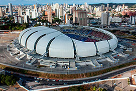 Arena das Dunas in Natal, Rio Grande do Norte. Image: Brazilian Government |
Explore more:
Related Consumer Information:
|
||||
Other Cities in South America: Asunción (Paraguay) - Bogotá D.C. (Colombia) - Brasilia, Rio de Janeiro, São Paulo, Salvador, (all Brazil) - Buenos Aires (Argentina) - Caracas (Venezuela) - Cayenne, Kourou (both French Guiana) - Georgetown (Guyana) - La Paz, Sucre (both Bolivia) - Lima (Peru) - Montevideo (Uruguay) - Paramaribo (Suriname) - Quito (Ecuador) - Santiago (Chile) |
||
Map Help [ show ] |
||
One World - Nations Online .:. let's care for this planet Promote that every nation assumes responsibility for our world. Nations Online Project is made to improve cross-cultural understanding and global awareness. More signal - less NOISE |
| Site Map
| Information Sources | Disclaimer | Copyright © 1998-2024:: nationsonline.org |