Nations Online
All Countries in the World
Nations Online All Countries in the World | |
Home  |
___ Satellite View and Map of the City of Vitória - Espírito Santo |
About the City of Vitória Satellite view showing Vitória, a port city and the capital of 'Espírito Santo' (Holy Spirit), one of the 26 Brazilian states. The city is located in the Southeast Region of Satellite view showing Vitória, a port city and the capital of 'Espírito Santo' (Holy Spirit), one of the 26 Brazilian states. The city is located in the Southeast Region of 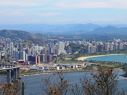 View of the city of Vitória from the Moreno hill. Image: Brunovix Vitória lies in a tropical zone influenced by an oceanic climate with only some rain from October until January. This is also the warmest season, the annual average temperature is around 27° C. Vitória's economy is based on two of Brazil's major important ports, the Port of Vitória (Porto de Vitória) and the Port of Tubarão, which opened in 1966 to export iron ore from the "Iron Quadrangle" in Minas Gerais. The Map shows a city map of Vitória with expressways, main roads and streets and the location of Vitória Airport known as Eurico de Aguiar Salles Airport (IATA Code: VIX) located about 10 km (6 mi) north of Vitória's city center. To find a location use the form below. |
|
| To find a location type: street or place, city, optional: state, country. |
Local Time Vitória:
Monday-July-13 18:28
Time zone: Brasilia Time (BRT): UTC/GMT -3 hoursDaylight Saving Time starts on the 3rd Sunday of October and ends on the 3rd Sunday of February shifts time offset to UTC/GMT -2 hours. |
|
φ Latitude, λ Longitude (of Map center; move the map to see coordinates): , |
||||||
| Google Earth: Searchable map/satellite view of the City of Vitória, Espírito Santo, Brazil. City Coordinates: 20°18′51″S 40°17′55″W |
Bookmark/share this page |
|||||
| More about Brazil: Cities - background notes and a searchable map/satellite view of other Brazilian cities: Largest cities in Brazil: Other Cities: Aracaju, Belém, Boa Vista, Campo Grande, Cuiabá, Florianópolis, Goiânia, João Pessoa, Macapá, Maceió, Natal, Palmas, Porto Alegre, Porto Velho, Recife, Rio Branco, São Luís, São Paulo, Teresina Country: Continent: |
Current Weather Conditions Vitória
External Links Vitória (official website) Wikipedia: Vitória Wikipedia entry: Vitória |
Explore more:
Related Consumer Information:
|
||||
Other Cities in South America: Asunción (Paraguay) - Bogotá D.C. (Colombia) - Buenos Aires (Argentina) - Caracas (Venezuela) - Cayenne, Kourou (both French Guiana) - Georgetown (Guyana) - La Paz, Sucre (both Bolivia) - Lima (Peru) - Montevideo (Uruguay) - Paramaribo (Suriname) - Quito (Ecuador) - Santiago (Chile) |
||
Map Help [ show ] |
||
One World - Nations Online .:. let's care for this planet Promote that every nation assumes responsibility for our world. Nations Online Project is made to improve cross-cultural understanding and global awareness. More signal - less NOISE |
| Site Map
| Information Sources | Disclaimer | Copyright © 1998-2024:: nationsonline.org |

