Nations Online
All Countries in the World
Nations Online All Countries in the World | |
Home  |
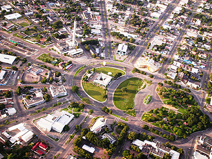
___ Satellite View and Map of the City of Boa Vista - Roraima
|
About the City of Boa Vista
Boa Vista was founded in 1830. In 1890 the settlement received town status, it was then known as Boa Vista do Rio Branco. In 1943 it became the capital of the newly created Federal Territory of Rio Branco. When you look at the map you can see that it is a planned city with a radial layout, resembling a fan (planned in 1944-46). |
|
| To find a location type: street or place, city, optional: state, country. |
Local Time Boa Vista:
Friday-July-10 23:24
Amazon Time (AMT): UTC/GMT -4 hours |
|
φ Latitude, λ Longitude (of Map center; move the map to see coordinates): , |
||||||
| Google Earth: Searchable map/satellite view of the City of Boa Vista, Roraima, Brazil. City Coordinates: 2°49′N 60°40′W |
Bookmark/share this page |
|||||
| More about Brazil: Cities - background notes and a searchable map/satellite view of other Brazilian cities: Largest cities in Brazil: Other Cities: Aracaju, Belém, Campo Grande, Cuiabá, Florianópolis, Goiânia, João Pessoa, Macapá, Maceió, Natal, Palmas, Porto Alegre, Porto Velho, Recife, Rio Branco, São Luís, São Paulo, Teresina, Vitória Country: Continent: External Links: Boa Vista (official website) Junina Boa Vista Website of the Festa Junina celebration in June in Boa Vista. Wikipedia: Boa Vista Wikipedia entry: Boa Vista |
Weather Conditions Boa Vista
|
Related Consumer Information:
|
||||
Other Cities in South America: Asunción (Paraguay) - Bogotá D.C. (Colombia) - Brasilia, Rio de Janeiro, São Paulo, Salvador, (all Brazil) - Buenos Aires (Argentina) - Caracas (Venezuela) - Cayenne, Kourou (both French Guiana) - Georgetown (Guyana) - La Paz, Sucre (both Bolivia) - Lima (Peru) - Montevideo (Uruguay) - Paramaribo (Suriname) - Quito (Ecuador) - Santiago (Chile) |
||
Map Help [ show ] |
||
One World - Nations Online .:. let's care for this planet Promote that every nation assumes responsibility for our world. Nations Online Project is made to improve cross-cultural understanding and global awareness. More signal - less NOISE |
| Site Map
| Information Sources | Disclaimer | Copyright © 1998-2024:: nationsonline.org |
 Satellite view showing Boa Vista (Great View) capital of