Nations Online
All Countries in the World
Nations Online All Countries in the World | |
Home  |
___ Satellite View and Map of the City of Belém - Pará |
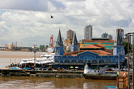
About the City of Belém Satellite view showing Belém (Portuguese for Bethlehem), a port city and the capital of Pará, the second largest state in Satellite view showing Belém (Portuguese for Bethlehem), a port city and the capital of Pará, the second largest state in The city is located in the Guajará Bay in the Northern Region of Brazil, about 100 km (60 mi) upstream from the Atlantic Ocean. Belém is known as the gate to the Amazon river, situated at the confluence of Guamá river and the Pará river, the southern arm of the mouth of the Amazon. In 1615 a Portuguese military expedition laid the foundation of the city by the construction of a wooden fort, what they named Presépio (manger). Today the city has a population of about 1.4 million inhabitants, more than 2.2 million people live in the metropolitan area. Belém lies 160 km south of the equator in a tropical rainforest climate zone with high temperatures, high humidity (85-90%) and a rainy season lasting literally the whole year. Belém's economy is based on the export of metals and natural products like Brazil nuts, pineapples, cassava (manioc), jute and wood veneers. The Map shows a city map of Belém with expressways, main roads and streets and the location of Belém Airport known as Val de Cans International Airport (IATA Code: BEL) located 11 km (7 mi) north of Belém's city center. To find a location use the form below. (Map Help) |
|
| To find a location type: street or place, city, optional: state, country. |
Local Time Belém:
Saturday-June-27 12:15
Time zone: Brasilia Time (BRT): UTC/GMT -3 hoursDaylight Saving Time starts on the 3rd Sunday of October and ends on the 3rd Sunday of February shifts time offset to UTC/GMT -2 hours. |
|
φ Latitude, λ Longitude (of Map center; move the map to see coordinates): , |
||||||
| Google Earth: Searchable map/satellite view of the City of Belém, Pará, Brazil. City Coordinates: 1°27′21″S 48°30′14″W |
Bookmark/share this page |
|||||
| More about Brazil: Cities - background notes and a searchable map/satellite view of other Brazilian cities: Largest cities in Brazil: Other Cities: Aracaju, Boa Vista, Campo Grande, Cuiabá, Florianópolis, Goiânia, João Pessoa, Macapá, Maceió, Natal, Palmas, Porto Alegre, Porto Velho, Recife, Rio Branco, São Luís, São Paulo, Teresina, Vitória Country: Continent: External Links: Belém (official website) Wikipedia: Belém Wikipedia entry: Belém |
Current Weather Conditions Belém weather station is at Val De Caes airport
|
Explore more:
Related Consumer Information:
|
||||
Other Cities in South America: Asunción (Paraguay) - Bogotá D.C. (Colombia) - Brasilia, Rio de Janeiro, São Paulo, Salvador, (all Brazil) - Buenos Aires (Argentina) - Caracas (Venezuela) - Cayenne, Kourou (both French Guiana) - Georgetown (Guyana) - La Paz, Sucre (both Bolivia) - Lima (Peru) - Montevideo (Uruguay) - Paramaribo (Suriname) - Quito (Ecuador) - Santiago (Chile) |
||
Map Help [ show ] |
||
One World - Nations Online .:. let's care for this planet Promote that every nation assumes responsibility for our world. Nations Online Project is made to improve cross-cultural understanding and global awareness. More signal - less NOISE |
| Site Map
| Information Sources | Disclaimer | Copyright © 1998-2024:: nationsonline.org |