Nations Online
All Countries in the World
Nations Online All Countries in the World | |
Home  |
___ Satellite View and Map of the City of Recife - Pernambuco
|
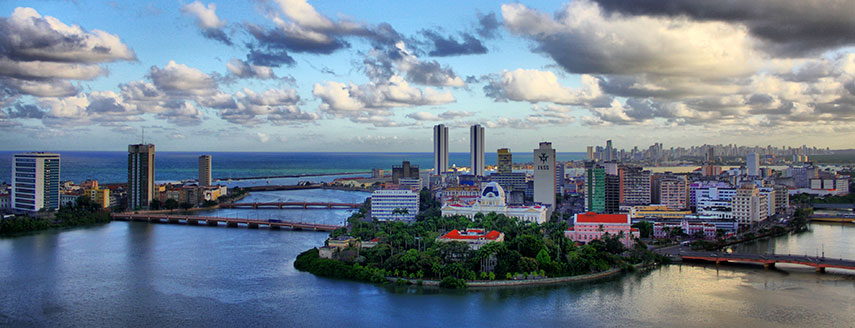 View of Recife and its bridges. Image: Américo Nunes |
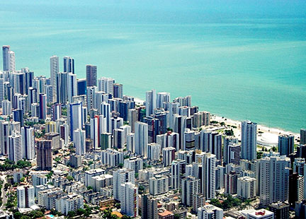
About the City of Recife Satellite view showing Recife, a major port and the capital of Pernambuco. The city is located at the far eastern tip of Satellite view showing Recife, a major port and the capital of Pernambuco. The city is located at the far eastern tip of The former settlement of colonial fishermen on a long stretched reef (Portuguese: recife), has developed in a fortified port city within about a hundred years. From 1630 on the Dutch Republic came to control almost half of Brazil's area and Mauritsstad (today part of Recife) was their capital until 1661, when New Holland was formally ceded to Portugal. Today the city has a population of almost 1.5 million inhabitants, more than 3.7 million people live in the metropolitan area, including Recife's neighborhoods and boroughs (est. 2012). The city is home to the Federal University of Pernambuco, and it is the cultural, economic, and political center in Pernambuco state. The city has a tropical climate, with average temperatures of 27° to 30° Celsius throughout the year. 2014 FIFA World Cup The city was one of the twelve host cities of the 2014 FIFA World Cup. Five group matches were held in the Arena Pernambuco stadium in June 2014. The Map shows map of the city of Recife with expressways, main roads and streets, and the location of Recife International Airport (IATA Code: CWB) named Recife/Guararapes-Gilberto Freyre International Airport located in Boa Viagem neighborhood about 12 km (7.5 mi) to the south of Downtown Recife. To find a location use the form below. |
|
| To find a location type: street or place, city, optional: state, country. |
Local Time Recife:
Saturday-June-27 13:37
Time zone: Brasilia Time (BRT): UTC/GMT -3 hoursDaylight Saving Time starts on the 3rd Sunday of October and ends on the 3rd Sunday of February shifts time offset to UTC/GMT -2 hours. |
|
φ Latitude, λ Longitude (of Map center; move the map to see coordinates): , |
||||||
| Google Earth: Searchable map/satellite view of the City of Recife, Pernambuco, Brazil. City Coordinates: 8°3′S 34°54′W |
Bookmark/share this page |
|||||
| More about Brazil: Cities - background notes and a searchable map/satellite view of other Brazilian cities: Largest cities in Brazil: Other Cities: Aracaju, Belém, Boa Vista, Campo Grande, Cuiabá, Florianópolis, Goiânia, João Pessoa, Macapá, Maceió, Natal, Palmas, Porto Alegre, Porto Velho, Rio Branco, São Luís, São Paulo, Teresina, Vitória Country: Continent: External Links Recife (official website) Recife Portal do Turismo (in Portuguese) Wikipyedia: Recife Wikipedia entry: Recife |
Current Weather Conditions Recife
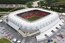 Arena Pernambuco in Recife, officially named Estádio Governador Carlos Wilson Rocha de Queirós Campos. Image: Brazilian Government |
Explore more:
Related Consumer Information:
|
||||
| Other Cities in South America: Asunción (Paraguay) - Bogotá D.C. (Colombia) - Brasilia, Rio de Janeiro, São Paulo, Salvador, (all Brazil) - Buenos Aires (Argentina) - Caracas (Venezuela) - Cayenne, Kourou (both French Guiana) - Georgetown (Guyana) - La Paz, Sucre (both Bolivia) - Lima (Peru) - Montevideo (Uruguay) - Paramaribo (Suriname) - Quito (Ecuador) - Santiago (Chile) |
||
Map Help [ show ] |
||
One World - Nations Online .:. let's care for this planet Promote that every nation assumes responsibility for our world. Nations Online Project is made to improve cross-cultural understanding and global awareness. More signal - less NOISE |
| Site Map
| Information Sources | Disclaimer | Copyright © 1998-2024:: nationsonline.org |