Nations Online
All Countries in the World
Nations Online All Countries in the World | |
Home  |
___ Satellite View and Map of the City of Macapá - Amapá |
About the City of Macapá Satellite view showing Macapá, capital of Amapá, one of the 26 Brazilian states. The city is located in the North Region of Satellite view showing Macapá, capital of Amapá, one of the 26 Brazilian states. The city is located in the North Region of 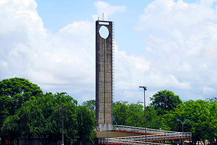 The Equator Line Monument in Macapá is one of several monuments around the world marking the fictive line which divides the Earth into the two Hemispheres, the Northern and the Southern Hemisphere. Image: Jorge Andrade The largest city in Amapá lies on the equator and has a tropical monsoon climate with a lot of rain, (hence rainforest). The wet season starts in December and lasts until August. The annual average temperature is around 27° C. Since the early 1990s the Free Trade Zone of Macapa/Santana offers business opportunities for its industry of mining, timber extraction, cattle ranching, fish farming, the cultivation of açaí palms, copal and medicinal plants. The Map shows a city map of Macapá with expressways, main roads and streets and the location of Macapá Airport known as Alberto Alcolumbre International Airport (IATA Code: MCP) located about 3 km (2 mi) from Macapá city center. To find a location use the form below. (Map Help) |
|
| To find a location type: street or place, city, optional: state, country. |
Local Time Macapá:
Friday-July-17 05:14
Brasilia Time (BRT): UTC/GMT -3 hours |
|
φ Latitude, λ Longitude (of Map center; move the map to see coordinates): , |
||||||
| Google Earth: Searchable map/satellite view of the City of Macapá, Amapá, Brazil. City Coordinates: 0°2′2″N 51°3′59″W |
Bookmark/share this page |
|||||
| More about Brazil: Cities - background notes and a searchable map/satellite view of other Brazilian cities: Largest cities in Brazil: Other Cities: Aracaju, Belém, Boa Vista, Campo Grande, Cuiabá, Florianópolis, Goiânia, João Pessoa, Maceió, Natal, Palmas, Porto Alegre, Porto Velho, Recife, Rio Branco, São Luís, São Paulo, Teresina, Vitória Country: Continent: |
Current Weather Conditions Macapá
External Links: Macapá (official website) Wikipedia: Macapá Wikipedia entry: Macapá |
Explore more:
Related Consumer Information:
|
||||
Other Cities in South America: Asunción (Paraguay) - Bogotá D.C. (Colombia) - Brasilia, Rio de Janeiro, São Paulo, Salvador, (all Brazil) - Buenos Aires (Argentina) - Caracas (Venezuela) - Cayenne, Kourou (both French Guiana) - Georgetown (Guyana) - La Paz, Sucre (both Bolivia) - Lima (Peru) - Montevideo (Uruguay) - Paramaribo (Suriname) - Quito (Ecuador) - Santiago (Chile) |
||
Map Help [ show ] |
||
One World - Nations Online .:. let's care for this planet Promote that every nation assumes responsibility for our world. Nations Online Project is made to improve cross-cultural understanding and global awareness. More signal - less NOISE |
| Site Map
| Information Sources | Disclaimer | Copyright © 1998-2024:: nationsonline.org |

