Nations Online
All Countries in the World
Nations Online All Countries in the World | |
Home  |
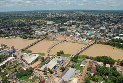
___ Satellite View and Map of the City of Rio Branco - Acre |
About the City of Rio Branco
Rio Branco is the oldest urban settlement in Acre which has evolved since the late 19th century from a small village on the right bank of the Acre river to the capital of Acre state (since 1962).
Today (2014) the city has a population of almost 360,000 people. |
|
| To find a location type: street or place, city, optional: state, country. |
Local Time Rio Branco:
Thursday-July-16 13:26
Amazon Time (AMT): UTC/GMT -5 hours |
|
φ Latitude, λ Longitude (of Map center; move the map to see coordinates): , |
||||||
| Google Earth: Searchable map/satellite view of the City of Rio Branco, Acre, Brazil. City Coordinates: 9°58′29″S 67°48′36″W |
Bookmark/share this page |
|||||
| More about Brazil: Cities - background notes and a searchable map/satellite view of other Brazilian cities: Country: Continent: |
Weather Conditions Rio Branco
External Links: Rio Branco (official website) Wikipedia: Rio Branco Wikipedia entry: Rio Branco |
Related Consumer Information:
|
||||
Other Cities in South America: Asunción (Paraguay) - Bogotá D.C. (Colombia) - Brasilia, Rio de Janeiro, São Paulo, Salvador, (all Brazil) - Buenos Aires (Argentina) - Caracas (Venezuela) - Cayenne, Kourou (both French Guiana) - Georgetown (Guyana) - La Paz, Sucre (both Bolivia) - Lima (Peru) - Montevideo (Uruguay) - Paramaribo (Suriname) - Quito (Ecuador) - Santiago (Chile) |
||
Map Help [ show ] |
||
One World - Nations Online .:. let's care for this planet Promote that every nation assumes responsibility for our world. Nations Online Project is made to improve cross-cultural understanding and global awareness. More signal - less NOISE |
| Site Map
| Information Sources | Disclaimer | Copyright © 1998-2024:: nationsonline.org |
 Satellite view showing Rio Branco (White River), capital of Acre, one of the 26 Brazilian states. The city is located in the western extreme of the North Region of