| Home |
||
___Administrative Map of Brazil |
| The map shows Brazil and the location of its 26 states and the one Federal district. The country is situated in the east-central part of South America, bordering the Atlantic Ocean in east. Brazil occupies an area of 8,514,877 km² (3,287,597 sq mi), it is the fifth largest country in the world and also the largest country in South America and in the Southern Hemisphere. It is bordered by French Guiana, Suriname, Guyana, and Venezuela in north, by Colombia in north-west, by Peru, Bolivia, and Paraguay in west, by Argentina in south-west, and by Uruguay in south. Brazil has a population of 192 million people (2011), the national capital is Brasília, largest city and Brazil's economic capital is Sao Paulo, the most famous city is Rio de Janeiro. Spoken language is predominantly Brazilian Portuguese. Map is showing Brazil with international borders to neighboring countries, state capitals, its largest cities with and international airports, highways and main roads. |
 Bookmark/share this page |
 One World - Nations Online all countries of the world |
|
|
||
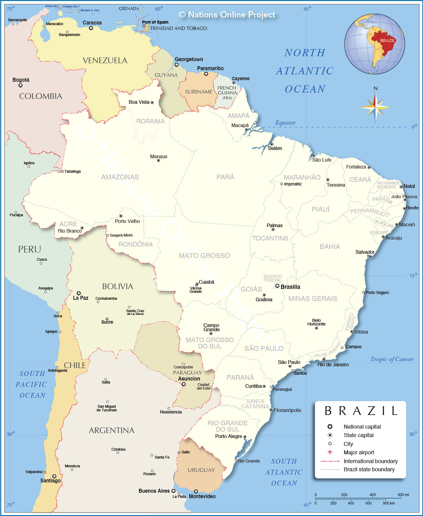 Administrative Map of Brazil |
|||||||
States of BrazilBrazil is a federation of 26 States and one Federal district (Brasília)List of Brazilian States (state capitals in parentheses): Acre (Rio Branco), Alagoas (Maceió), Amapá (Macapá), Amazonas (Manaus), Bahia (Salvador), Ceará (Fortaleza), Distrito Federal (Brasília), Espírito Santo (Vitória), Goiás (Goiânia), Maranhão (São Luís), Mato Grosso (Cuiabá), Mato Grosso do Sul (Campo Grande), Minas Gerais (Belo Horizonte), Pará (Belém), Paraíba (João Pessoa), Paraná (Curitiba), Pernambuco (Recife), Piauí (Teresina), Rio de Janeiro (Rio de Janeiro), Rio Grande do Norte (Natal), Rio Grande do Sul (Porto Alegre), Rondônia (Porto Velho), Roraima (Boa Vista), Santa Catarina (Florianópolis), São Paulo (São Paulo), Sergipe (Aracaju), Tocantins (Palmas) |
Current Weather Conditions Brasília
|
More about Brazil: Cities - some information and a searchable map/satellite view of: Country: Continent: |
Advertisements:
|
||||
Maps of other Countries in South America: Argentina Map, Bolivia Map, Chile Map, Colombia Map, Ecuador Map, French Guiana Map, Guyana Map, Paraguay Map, Peru Map, Suriname Map, Uruguay Map, Venezuela Map Maps of Countries in Central America: Belize Map, Costa Rica Map, El Salvador Map, Guatemala Map, Honduras Map, Nicaragua Map, Panama Map All Countries of the World |
|||||||
One World - Nations Online .:. let's care for this planet Made to improve cross-cultural understanding and global awareness. |
| Site Map
| Information Sources | Disclaimer: Privacy Policy, etc. Contact: [email protected] | Copyright © 1998-2016 :: nationsonline.org |
