Nations Online
All Countries in the World
Nations Online All Countries in the World | |
Home  |
___ Satellite View and Map of the City of Cayenne, French Guiana |
About CayenneSatellite view is showing Cayenne, the territorial capital of the French overseas region ofCayenne has a city population of about 50,000 people. The official language of French Guiana is, what else, French. The map shows a city map of Cayenne with expressways, main roads and streets, zoom out to find the location of Cayenne-Rochambeau Airport (IATA code: CAY) about 9 mi (15 km) south of the city. To find a location use the form below. To view the map, click on the "Map" button. |
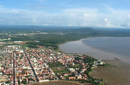 Aerial view of the city of Cayenne, capital of the French overseas region French Guiana. Image: ADM Bookmark/share this page |
| To find a location type: street or place, city, optional: state, country. |
Local Time French Guiana:
Sunday-July-26 03:10
Standard time zone: French Guiana Time (GFT) UTC/GMT -3 hours |
|
φ Latitude, λ Longitude (of Map center; move the map to see coordinates): , |
||||||
| Google Earth: Searchable Map and Satellite view of Cayenne, French Guiana (Guyane). |
||||||
| More about French Guiana: Landmarks: Country: Historically related Countries: Continent: External Link: Wikipedia: Cayenne |
Current Weather Conditions Cayenne
|
Related Consumer Information:
|
||||
Other Cities in South America: Asunción (Paraguay) - Bogotá D.C. (Colombia) - Brasilia, Rio de Janeiro, São Paulo, Salvador, (all Brazil) - Buenos Aires (Argentina) - Caracas (Venezuela) - Georgetown (Guyana) - La Paz, Sucre (both Bolivia) - Lima (Peru) - Montevideo (Uruguay) - Paramaribo (Suriname) - Port of Spain (Trinidad and Tobago) - Quito (Ecuador) - Santiago (Chile) |
||
Map Help [ show ] |
||
One World - Nations Online .:. let's care for this planet Promote that every nation assumes responsibility for our world. Nations Online Project is made to improve cross-cultural understanding and global awareness. More signal - less NOISE |
| Site Map
| Information Sources | Disclaimer | Copyright © 1998-2024:: nationsonline.org |

