Nations Online
All Countries in the World
Nations Online All Countries in the World | |
Home  |
___ Satellite View and Map of Roraima, Brazil |
Searchable Map and Satellite View of Roraima state using Google Earth Data Satellite view is showing Roraima, the northernmost of the Brazilian states (estados), located in Região Norte, the North Region of Satellite view is showing Roraima, the northernmost of the Brazilian states (estados), located in Região Norte, the North Region of The state came into existence 1943. Together with apart of the Amazonas state Brazil's government created the territory of Rio Branco which became Roraima in 1962, named after Mt. Roraima. 26 years later in 1988 the territory became the second youngest member state in the Federation (before Tocantins). With an area of 224,299 km² Roraima is about twice the size of Honduras or about twice the size of the U.S. state of New Mexico. Almost half of the area are Indigenous Territories (Terras Indígenas). Roraima is sparsely populated with just 500,000 people (2012). The southern part of the least populated state in Brazil is located in a peripheral region of the Amazon River and is covered by the Amazon rainforest, which contains the greatest biodiversity in a tropical forest in the world. In Roraima's central east there is a strip of a tropical savanna ecoregion. The north is covered by grassland. Major rivers in the state are the Rio Branco and its main tributaries the Takutu River and the Uraricoera. Highest point is Mount Roraima at 2,734 metres (8,970 ft.) located at the point where the boundaries of Venezuela, Brazil and Guyana meet. Roraima lies in a tropical climate zone with a hot and humid wet season from April until September. Annual average temperatures are between 23° and 31° C. Roraima's economy is mainly based on a variety of services, some industry, agriculture (13%) and hydroelectric power. The Map shows Roraima with expressways and main roads (just zoom in to see more details ;∙) and the location of Boa Vista Airport (IATA Code: BVB), a main gateway to the state. To find a location use the form below. (Map Help) |
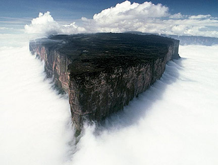 Roraima (Tepuy Roraima) is the highest mountain of the Pakaraima chain, it marks the triple border point of Brazil, Guyana, and Venezuela. Bookmark/share this page |
| To find a location type: street or place, city, optional: state, country. |
Local Time Roraima:
Friday-July-3 02:57
Amazon Time (AMT): UTC/GMT -4 hours |
|
φ Latitude, λ Longitude (of Map center; move the map to see coordinates): , |
||||||
| Google Earth: Searchable map/satellite view of Roraima, Brazil. |
||||||
| City Coordinates: 10°11′S 48°20′W |
||||||
| More about Brazil: Cities - background notes and a searchable map/satellite view of other Brazilian cities: Country: Continent: External Links Roraima (official website) Wikipedia: Roraima Wikipedia entry: Roraima |
Current Weather Conditions Boa Vista Weather station at Boa Vista international airport .
|
Related Consumer Information:
|
||||
Other Countries and Capitals in South America: Asunción (Paraguay) - Bogotá D.C. (Colombia) - Buenos Aires (Argentina) - Caracas (Venezuela) - Cayenne, Kourou (both French Guiana) - Georgetown (Guyana) - La Paz, Sucre (both Bolivia) - Lima (Peru) - Montevideo (Uruguay) - Paramaribo (Suriname) - Quito (Ecuador) - Santiago (Chile) |
||
|
||
Map Help [ show ] |
||
One World - Nations Online .:. let's care for this planet Promote that every nation assumes responsibility for our world. Nations Online Project is made to improve cross-cultural understanding and global awareness. More signal - less NOISE |
| Site Map
| Information Sources | Disclaimer | Copyright © 1998-2024:: nationsonline.org |

