Nations Online
All Countries in the World
Nations Online All Countries in the World | |
Home  |
___ Satellite View and Map of Tocantins, Brazil |
About Tocantins state Satellite view is showing Tocantins, the youngest of the Brazilian states (estados), located in the southeast of the Northern Region of Satellite view is showing Tocantins, the youngest of the Brazilian states (estados), located in the southeast of the Northern Region of 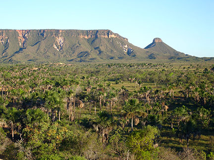 Jalapao, a state park located in eastern Tocantins is considered to be one of the biggest attractions of the Cerrado, a hilly tropical savanna ecoregion in Brazil. Image: Vitor With an area of 277,620 km² Tocantins is a little smaller than Ecuador or about the size of the U.S. state of Texas. Major rivers in the state are the Araguaia and the Tocantins river. Highest point is an unnamed peak near the town of Paranã in the Serra das Traíras mountain range. Tocantins has a population of about 1.5 million people (2012). Most portions of the state lie within the Cerrado, Brazil's vast tropical savanna ecoregion and it has therefore a tropical savanna climate with high average temperatures. There is a dry winter season from May to October and a rainy season from December to April. Tocantins' economy is mainly based on a variety of services, some industry, agriculture (13%) and hydroelectric power. The Map shows Tocantins with expressways and main roads (just zoom in to see more details ;∙) and the location of Palmas Airport Airport (IATA Code: PMW), a main gateway to the state. To find a location use the form below. (Map Help) |
|
| To find a location type: street or place, city, optional: state, country. |
Local Time Tocantins:
Thursday-July-9 07:42
Time zone: Brasilia Time (BRT): UTC/GMT -3 hours |
|
φ Latitude, λ Longitude (of Map center; move the map to see coordinates): , |
||||||
| Google Earth: Searchable map/satellite view of Tocantins, Brazil. |
Bookmark/share this page |
|||||
| More about Brazil: Cities - background notes and a searchable map/satellite view of other Brazilian cities: Country: Continent: External Links Tocantins (official website) Wikipedia: Tocantins Wikipedia entry: Tocantins |
Current Weather Conditions Weather station at Palmas airport
|
Related Consumer Information:
|
||||
Other Countries and Capitals in South America: Asunción (Paraguay) - Bogotá D.C. (Colombia) - Buenos Aires (Argentina) - Caracas (Venezuela) - Cayenne, Kourou (both French Guiana) - Georgetown (Guyana) - La Paz, Sucre (both Bolivia) - Lima (Peru) - Montevideo (Uruguay) - Paramaribo (Suriname) - Quito (Ecuador) - Santiago (Chile) |
||
Map Help [ show ] |
||
One World - Nations Online .:. let's care for this planet Promote that every nation assumes responsibility for our world. Nations Online Project is made to improve cross-cultural understanding and global awareness. More signal - less NOISE |
| Site Map
| Information Sources | Disclaimer | Copyright © 1998-2024:: nationsonline.org |

