Nations Online
All Countries in the World
Nations Online All Countries in the World | |
Home  |
___ Searchable map and satellite view of Tel Aviv |
 Tel Aviv at the beach, seen from Jaffa, the southern and oldest part of Tel Aviv-Jaffa. Image: Ruby1619 |
About Tel Aviv Map is showing Tel Aviv, a metropolitan city on the Mediterranean coast of Map is showing Tel Aviv, a metropolitan city on the Mediterranean coast of The city is located north of the ancient port of Jaffa, it was founded as a suburb of Jaffa by Russian Jewish immigrants in 1909 and named Tel Aviv (literall:y "Hill of Spring") a year later. 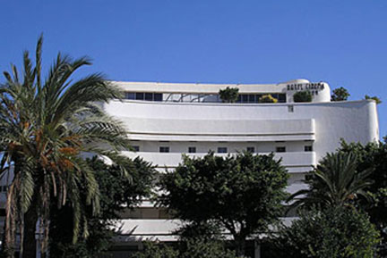 The White City, Esther Theater, formerly an International Style movie theater built in the 1930s, now Sinema Hotel, Tel Aviv. Photo: deror avi Official languages are Hebrew and Arabic, but being a multicultural city, many languages are spoken alongside Hebrew like Russian, French, Spanish, Tagalog, Thai, Arabic, Amharic and English. Tel Aviv is listed in National Geographic's 2010 Top 10 List of Beach Cities, described there as: the "Miami Beach on the Med. Tel Aviv is the Dionysian counterpart to religious Jerusalem".. One attraction of the Tel Aviv is "The White City" the world's largest concentration of buildings in the International style using Bauhaus design principles. The city was constructed from the early 1930s until the 1950s. Since 2003 it is a World Cultural Heritage site Zoom out to find the location of Ben Gurion International Airport |
|
| To find a location type: street or place, city, optional: state, country. |
Local Time Israel:
Sunday-April-28 17:47
Israel Standard Time (IST): UTC/GMT +2 hoursSummer time offset (IDT): UTC/GMT +3 hours |
|
φ Latitude, λ Longitude (of Map center; move the map to see coordinates): , |
||||||
| Google Maps: Searchable map and satellite view of Tel Aviv, Israel. City Coordinates: 32°4′N 34°47′E |
Bookmark/share this page |
|||||
| More about Israel: Landmarks: Cities: Country: Israel key statistical data. Continent: |
Current Weather Conditions Tel Avi:
External Links: Tel Aviv (official web site) Visit TLV (official tourism web site) Haaretz Local news. Wikipedia: Tel Aviv |
Related Consumer Information:
|
||||
One World - Nations Online .:. let's care for this planet Promote that every nation assumes responsibility for our world. Nations Online Project is made to improve cross-cultural understanding and global awareness. More signal - less NOISE |
| Site Map
| Information Sources | Disclaimer | Copyright © 1998-2023 :: nationsonline.org |

