About Turkey
The map shows Turkey, officially the Republic of Türkiye, a country on the Anatolian peninsula in western Asia with a small enclave in Thrace in the
Balkan region of southeastern Europe. The main portion of the Turkish state is located on the Anatolia peninsula, also known as Asia Minor, the westernmost part of Asia. Turkey is a unitary state with a central government.
The country is bounded by the Aegean Sea in the west, the
Mediterranean Sea in the south, and the
Black Sea in the north. Turkey borders
Armenia,
Iran, and
Azerbaijan (the exclave of Nakhchivan) in the east,
Georgia in the northeast,
Bulgaria and
Greece in the northwest, and
Iraq and
Syria in the southeast.
Turkey shares maritime borders with
Cyprus,
Egypt,
Romania,
Russia, and
Ukraine.
There are two narrow straits in northwestern Turkey, the Bosporus, which connects the Black Sea with the Sea of Marmara, and the Dardanelles, which connect the Aegean arm of the Mediterranean Sea with the Sea of Marmara.
The highest mountain in Turkey is Ağrı Dağı or
Mount Ararat, at 5,137 m (16,854 ft).
With an
area of 783,562 km², the country is more than twice the size of
Germany or slightly smaller than the U.S. states of
Texas and
Louisiana combined.
Turkey has a
population of 84.7 million people (in 2022); largest city is
Istanbul, the second-largest city and national capital is
Ankara; spoken
languages are Turkish (official), Kurdish, and Arabic.
More about Turkey
Regions of Turkey
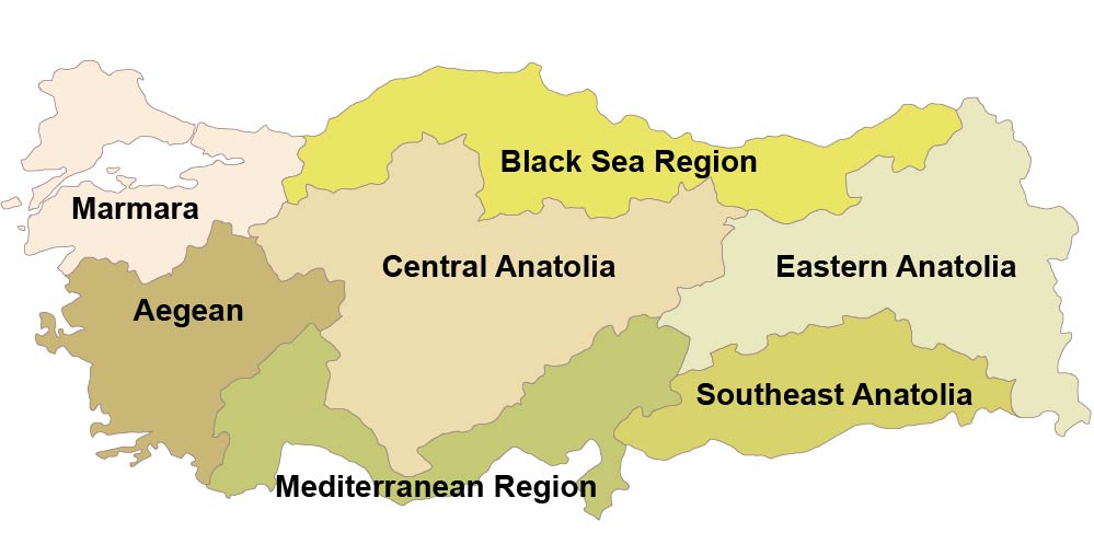
Turkey can be subdivided into seven major geographical regions.
 Map of Administrative Regions of Turkey.
Turkey's regions roughly correspond to the country's geographic regions. The country is subdivided into 81 provinces and further divided into 957 districts.
The
Marmara region in the northwestern part of the country is situated on both continents, Europe and Asia. It is the most densely populated region in the country. Turkey's largest city Istanbul is located within the area. The Marmara region was home to the city of Troy. The
Archaeological Site of Troy 
is a UNESCO World Heritage Site.
The
Black Sea region is a long-stretched mountainous region along the
Black Sea with a predominantly rural population. Major cities are Samsun, a Black Sea port, the port city of Zonguldak, and Trabzon, a main port on the historical Silk Road, which was the capital of the Empire of Trebizond.
The
Aegean region shares much of the history of Ancient Greece, home to the city-states of Ephesus, Miletus, and Halicarnassus (today Bodrum). The Aegean region is also one of Turkey's prominent tourism centers.
The
Mediterranean region is a mountainous strip of land along the Mediterranean Sea. The Taurus mountain range in the region separates the Mediterranean coastal area from the Anatolian Plateau. Alanya and Antalya are two popular resort towns on the eastern portion of the Turkish Riviera in the country's Mediterranean region.
Central Anatolia is the heartland of Turkey. The historical region is home to the country's capital Ankara and other major cities like Konya and Kayseri. Also located in central Anatolia is Cappadocia, the ancient region between Lake Tuz and the Euphrates, famous for its "fairy chimneys." The landscape where erosion shaped the soft volcanic rock into thousands of strangely shaped towers is now a hangout for hot-air balloons.
Mountainous
Southeast Anatolia is also known as Turkish Kurdistan. It borders Syria in the south and Iraq in the southeast. In ancient times Southeast Anatolia was part of the historical region of northwestern Mesopotamia, the site of the earliest urban civilizations. There are two UNESCO World Heritage Sites in Southeast Anatolia,
Nemrut Dağ (Mount Nemrut); erected on its summit are a number of large statues surrounding the mausoleum of Antiochus I (69–34 B.C.), who reigned over the Commagene kingdom. The archaeological site of
Göbekli Tepe presents monumental T-shaped pillars. The world’s oldest stone structures were erected by an unknown civilization between 9,600 and 8,200 BCE, a time that predates
Stonehenge by 6,000 years.
The
Eastern Anatolia region is the easternmost part of Turkey, formerly part of Western Armenia. It is Turkey's region with the lowest population density. The main economic activity is agriculture and animal husbandry. The main urban centers are Agri (Ağrı), a city with an agriculture industry; Van, a major city near the Turkish border with Iran, lies on the shores of
Lake Van, the largest lake in Turkey and one of the world's largest lakes with no outlet. Erzurum is a university town and a popular winter sports destination in Turkey.
Turkish cities
Major Turkish cities with a population of more than one million people.
Izmir, the largest city in the Aegean Region, is a seaport and a naval base on an inlet of the Aegean Sea.
Bursa is the capital of Bursa province, situated 30 km south of the southern coast of the Sea of Marmara along the foothills of Mount Uludag; it was the capital of the Ottoman Empire from 1326 to 1402.
Bursa and Cumalıkızık: the Birth of the Ottoman Empire 
is a UNESCO World Heritage Site.
Adana is the largest city in the Mediterranean Region and the capital of the Adana province.
Gaziantep, a city with an ancient history, is situated about 120 km (75 mi) north of Aleppo, Syria. The city is famous for its gastronomy.
Konya is an industrial city in central Anatolia. Konya is famous for its
Whirling Dervishes (Sufi). The city was the Seljuk capital (Sultanate of Rum) towards the end of the 11th century and later became the capital of the Ottoman province of
Karaman Eyalet.
Antalya is located on Anatolia's southwest coast, known as the Turkish Riviera. Antalya province is the center of Turkey's tourism industry and one of the Mediterranean's leading tourism destinations.
Kayseri is an industrialized city in Central Anatolia and the trailhead for the tourist attractions in Cappadocia.
Cities in Turkey
The Map shows the location of the following cities and towns in Turkey:
Adana, Adapazari, Adryaman, Afyon, Agri, Aksaray, Akyaka, Anamur, Ankara, Antakya (Antioch), Antalya, Ardahan, Artvin, Aydin, Balikesir, Bandirma, Bartin, Batman, Bayburt, Bergama, Bilecik, Bingöl, Bitlis, Bodrum, Bolu, Burdur, Bursa, Çanakkale, Çankiri, Çorum, Denizli, Didim (Didyma), Divrigi, Diyarbakir, Düzce, Edirne, Edremit, Elazig, Erzincan, Erzurum, Eskisehir, Fethiye, Finike, Gaziantep, Giresun, Gümüshane, Hakkâri, Igdir, Iskenderun, Isparta, Istanbul, Izmir, Izmit, Kahramanmaras, Karabük, Karaman, Kars, Kas, Kastamonu, Kayseri, Kilis, Kirikkale, Kirklareli, Kirsehir, Konya, Kumluca, Kütahya, Malatya, Manavgat, Manisa, Mardin, Marmaris, Mersin, Mugla, Mus, Nevsehir, Nigde, Nusaybin, Ordu, Osmaniye, Rize, Samsun, Sanliurfa, Siirt, Silifke, Silopi, Sinop, Sivasirnak, Siverek, Soma, Tarsus, Tatvan, Tekirdag, Tokat, Trabzon, Tunceli, Usak, Van, Yalova, Yozgat, Yumurtalik, and Zonguldak.
Advertisements:


