Nations Online
All Countries in the World
Nations Online All Countries in the World | |
Home  |
___ Satellite View and Map of the City of Zagreb, Croatia |
|
About Zagreb Satellite view is showing Zagreb, largest city and the national capital of Satellite view is showing Zagreb, largest city and the national capital of 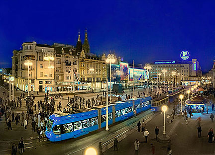 Evening on Ban Jelačić (Jelačić plac), the central square of Zagreb, near Zagreb's old city cores of Kaptol and Gradec. Image: © Miljenko Hegedic Zagreb is Croatia's principal city, it is the cultural, scientific, economic, political and administrative center of the country with a population of about 800,000 inhabitants, more than 1.2 million people live in its urban area. Spoken language is Croatian. Zagreb is seat of the Croatian Government and the Croatian Parliament (Hrvatski sabor). It is home to the University of Zagreb Just zoom in (+) to see Zagreb Cathedral, north of Jelačić Square. The Map shows a city map of Zagreb with expressways, main roads and streets, and the location of Zagreb International Airport To find a location use the form below. |
|
| To find a location type: street or place, city, optional: state, country. |
Local Time Zagreb:
Wednsday-April-17 19:52
Standard Time Zone (CET): UTC/GMT +1 hourCEST (Daylight Saving Time) in use from end of March until end of October: time zone offset: UTC/GMT +2 hours |
|
φ Latitude, λ Longitude (of Map center; move the map to see coordinates): , |
||||||
| Sorry! Google's pricing policy has made it impossible for us to continue showing Google Maps. We apologize for any inconvenience. Google Map: Searchable map and satellite view of Zagreb, Croatia. City Coordinates: 45°49′0″N 15°59′0″E |
Bookmark/share this page |
|||||
| More about Croatia: Country: Key statistical data of Croatia. Continent: Political Map of the Mediterranean Region. Political Map of the Balkans. External Links City of Zagreb Zagreb's official website. Wikipedia: Zagreb Wikipedia entry Zagreb. |
Zagreb Weather Conditions:
|
Related Consumer Information:
|
||||
| Cities in the Mediterranean Athens, Barcelona, Florence, Istanbul, Lisbon, Ljubljana, Madrid, Monaco, Milan, Naples, Rome, San Marino, Tirana, Valletta, Vatican City, Venice Alexandria, Algiers, Beirut, Benghazi, Cairo, Jerusalem, Nicosia, Tripoli, Tunis, Tel Aviv Maps of other Countries in Southern Europe Croatia Map, Cyprus Map, Greece Map, Italy Map, Macedonia Map, Vatican City State Map Montenegro Map, Portugal Map, Serbia Map, Slovenia Map, Spain Map, Turkey Map Searchable Maps of other Countries in Southern Europe Croatia, Cyprus, Greece, Italy, Macedonia, Vatican City State Montenegro, Portugal, Serbia, Slovenia, Spain, Turkey Profiles of other Countries in Southern Europe Croatia, Cyprus, Greece, Italy, Macedonia, Vatican City State Montenegro, Portugal, Serbia, Slovenia, Spain, Turkey |
||||||
| Map Help [ show ]
|
||||||
One World - Nations Online .:. let's care for this planet Promote that every nation assumes responsibility for our world. Nations Online Project is made to improve cross-cultural understanding and global awareness. More signal - less NOISE |
| Site Map
| Information Sources | Disclaimer | Copyright © 1998-2023 :: nationsonline.org |
One World - Nations Online .:. let's care for this planet Made to improve cross-cultural understanding and global awareness. |
|
| Site Map | Information Sources | Advertise with OWNO | Disclaimer: Privacy Policy, etc. | Contact: [email protected] | Copyright © 1998-2013 :: nationsonline.org |


