Nations Online
All Countries in the World
Nations Online All Countries in the World | |
Home  |
___ Satellite View and Map of the City of Amman (عمان) |
About the City of Amman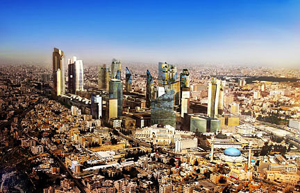 Amman, the future Central Business District, Abdali New Downtown. Image: Joeyzaza History (short version) The city was inhabited since prehistoric times, it was the capital of the Ammonites from the 13th to the 6th centuries b.c. During this time it was engaged in a struggle with the Israelites that ended when King David captured the city c. 1010 b.c. It was later captured by Ptolemy Philadelphus of Egypt who rebuilt the city between 285 and 246 b.c. In 63 b.c. it became a city of the Decapolis, a group of ten cities on the eastern frontier of the Roman Empire in Judea and Syria. In 1921, under Sharif Abdullah bin al-Husayn it became the capital of Transjordan (now Jordan). 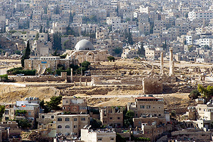 Umayyad Palace on the summit of Citadel Hill, a national historic site in the center of downtown Amman. Image: David Bjorgen Some attractions you will find in Amman: the Amman Citadel, a historic site in the center of downtown Amman, the Jordan Archaeological Museum is located in the Citadel. The Roman Theatre, a restored ancient Roman theater in Downtown. King Abdullah I Mosque, a modern mosque built between 1982 and 1989. For a shopping experience you might visit Wakalat Street, with its innumerable cafes, restaurants and, yes shopping malls. The Map shows a city map of Amman with expressways, main roads and streets, zoom out to find Queen Alia International Airport (IATA code: AMM) situated 35 km (21.5 mi) by road (via Route 15) south of Amman. To find a location use the form below. To view just the map, click on the "Map" button. |
|
| To find a location type: street or place, city, optional: state, country. |
Local Time Jordan:
Thursday-April-25 23:39
UTC/GMT +2 hours
Daylight saving time from end of March till end of OctoberUTC/GMT +3 hours |
|
φ Latitude, λ Longitude (of Map center; move the map to see coordinates): , |
||||||
| Sorry! Google's pricing policy has made it impossible for us to continue showing Google Maps. We apologize for any inconvenience. Google Map: Searchable map/satellite view of the city of Amman, Jordan. City Coordinates: 31°56′59″N 35°55′58″E |
Bookmark/share this page |
|||||
| More about Jordan: Jordan key statistical data. External Links: Greater Amman Municipality Amman City Government website. Queen Alia International Airport Official website of Amman International. Wikipedia: Amman Wikipedia entry on Amman |
Current Weather Conditions Amman:
|
Related Consumer Information:
|
||||
Searchable Maps of Cities in the Middle East Region: Abu Dhabi | Aden | Alexandria | Amman | Ankara | Baghdad | Baku | Beirut | Damascus | Doha | Dubai (City) Jerusalem | Kuwait (City) | Luxor | Manama | Mecca | Muscat | Nazareth | Nicosia | Port Said | Riyadh Sanaa | Sharm el-Sheikh | Suez | Tehran | Tel Aviv |
||||||
Map Help [ show ] |
||||||
One World - Nations Online .:. let's care for this planet Promote that every nation assumes responsibility for our world. Nations Online Project is made to improve cross-cultural understanding and global awareness. More signal - less NOISE |
| Site Map
| Information Sources | Disclaimer | Copyright © 1998-2023 :: nationsonline.org |

