
| Home |
|
|
|
___ Political Map of Republic of Macedonia | |
About Macedonia |
|
| Map is showing Republic of Macedonia occupies an area of 25,713 km², compared it is about two-third the size of Switzerland, or slightly larger than the U.S. state of Vermont. Macedonia's landscape is mountainous with deep basins and valleys, it is bisected from north west to south east by the Vardar River (Axios river), the country's major river, and also its longest. Highest point is Golem Korab (Maja e Korabit) with 2,764 m the highest mountain in both countries, the Republic of Macedonia and Albania. The Republic of Macedonia has a population of about 2 million people, capital city is |
 Bookmark/share this page |
 One World - Nations Online all countries of the world |
|
|
||
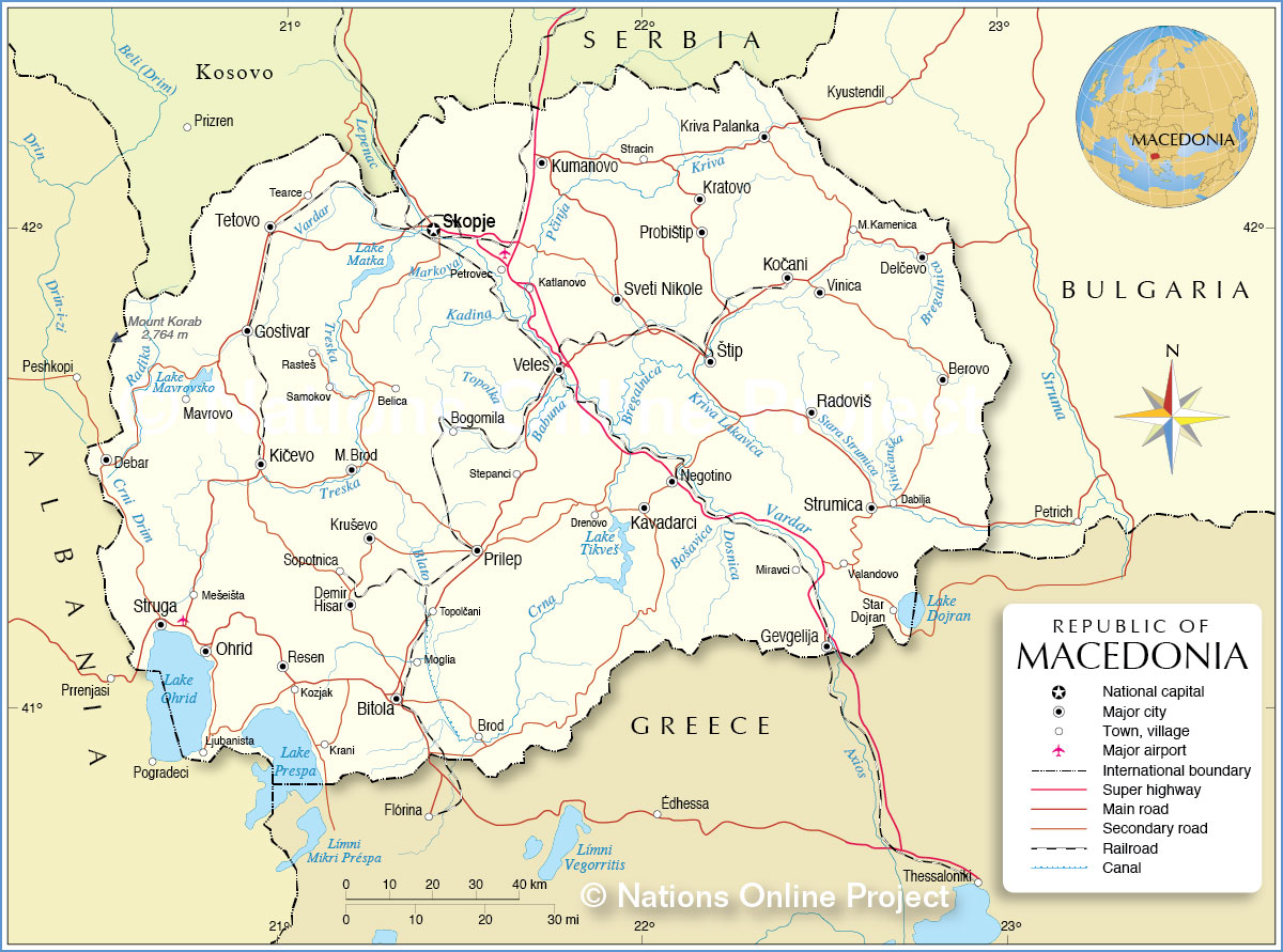 Political Map of Republic of Macedonia Map based on a UN map. Source: UN Cartographic Section | |||||||
| Cities and towns in the Republic of Macedonia Republic of Macedonian cities and towns depicted on the map: Largest cities/towns are: Skopje, Bitola, Kumanovo, Prilep, Tetovo, Veles, Stip, Ohrid, Gostivar, Strumica, Kavadarci, Kocani, Kicevo, Struga, Radovis, Gevgelija, Debar, Kriva Palanka, Sveti Nikole, and Negotino. Other towns and villages: Belica, Berovo, Bogomila, Brod, Dabilja, Delcevo, Demir Hisar, Drenovo, Katlanovo, Kozjak, Krani, Kratovo, Krusevo, Ljubanista, M. Brod, M. Kamenica, Mavrovo, Meseista, Miravci, Mrezicko, Novi Dojran (Star Dojran), Petrovec, Probistip, Rastes, Resen, Samokov, Sopotnica, Stepanci, Stracin, Tearce, Topolcani, Valandovo, and Vinica. |
More about the Republic of Macedonia: Cities: Country: Continent: Political Map of the Mediterranean Region. Political Map of the Balkans. |
Current Weather Conditions Skopje:
|
Related Consumer Information: |
||||
Other Cities in the Mediterranean Athens, Barcelona, Florence, Istanbul, Lisbon, Ljubljana, Madrid, Monaco, Milan, Naples, Rome, Tirana, San Marino, Valletta, Vatican City, Venice, Zagreb Alexandria, Algiers, Beirut, Benghazi, Cairo, Jerusalem, Nicosia, Tripoli, Tunis, Tel Aviv Maps of other Countries in Southern Europe Albania Map, Croatia Map, Cyprus Map, Greece Map, Italy Map,Vatican City State Map Montenegro Map, Portugal Map, Serbia Map, Slovenia Map, Spain Map, Turkey Map Searchable Maps of other Countries in Southern Europe Albania, Croatia, Cyprus, Greece, Italy, Vatican City State Montenegro, Portugal, Serbia, Slovenia, Spain, Turkey Profiles of other Countries in Southern Europe Albania, Croatia, Cyprus, Greece, Italy, Macedonia, Vatican City State Montenegro, Portugal, Serbia, Slovenia, Spain, Turkey |
One World - Nations Online .:. let's care for this planet Every nation is responsible for the current state of our world. |
| Site Map
| Information Sources | Disclaimer: Privacy Policy, etc. Contact: [email protected] | Copyright © 1998-2021 :: nationsonline.org |
