
One World
Nations Online
Countries in the World
|
|
|
One World Nations Online Countries in the World | |
Home  |
___ Satellite View and Map of the City of Rome (Roma), Italy (45-degree view available) |
 Forum Romanum in Rome, the Forum was the center of Roman life for centuries, the square is surrounded by the ancient ruins of several important former government buildings of the Roman Empire. Image: Stefan Bauer |
About Rome Map is showing Rome (in Italian: Roma) the capital of Italy. The city is located at the Tiber River in the west central part of the country, about 23 km east off the coast of the Mediterranean Sea.
According to tradition, ancient Rome was founded by Romulus (after whom it is named) in 753 BC on the Palatine Hill; as the town grew it spread to the other six hills of Rome. Since 1871 Rome is the capital of a unified Italy. Rome is known as the Eternal City, it is Italy's largest and most populous urban area with a population of about 2.8 million people (in 2013). Spoken language is Italian. The historic center of Rome is a UNESCO World Heritage Site titeled: 'Historic Centre of Rome, the Properties of the Holy See in that City Enjoying Extraterritorial Rights and San Paolo Fuori le Mura' According to the Sunday Times Travel Magazine, the city is amongst the world’s 12 sexiest cities. Just zoom in (+) to see the Colosseum in the center of the city. To the west of the Roman amphitheater is the Forum Romanum the former center of ancient Rome. The map shows a city map of Rome with expressways, main roads and streets, and the location of Rome's two airports: Rome Ciampino Airport (IATA code: CIA) is located 15 km (9.5 mi) southeast of central Rome. Leonardo da Vinci-Fiumicino Airport (IATA code: FCO) is located about 25 km (16 mi) by road, southwest of Rome's city center. To find a location use the form below. |
|
| To find a location type: street or place, city, optional: state, country. |
Local Time Rome:
Wednsday-April-24 06:37
Standard Time Zone (CET): UTC/GMT +1 hoursCEST (Daylight Saving Time) in use from end of March until end of October: time zone offset: UTC/GMT +2 hours |
|
φ Latitude, λ Longitude (of Map center; move the map to see coordinates): , |
||||||
| Google Earth: Searchable map and satellite view of Rome (Roma), Italy. City Coordinates: 41°54′N 12°30′E |
Bookmark/share this page |
|||||
| More about Italy: Landmarks: Cities: Country: Vatican City: Continent: External Links Comune di Rome Rome's official website. Turismo Roma Rome's official tourism website. Wikipedia: Rome Wikipedia entry Rome. |
Current Weather Conditions Rome
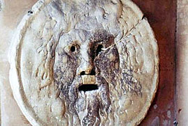 Bocca della Verità - The Mouth of the Truth is a marble image of a man-like face, located in the portico of the medieval church of Santa Maria in Cosmedin in Rome. It was believed that if one told a lie with one's hand in the mouth of the sculpture, it would be bitten off. |
Explore more:
Related Consumer Information:
|
||||
Cities in the Mediterranean Athens, Barcelona, Florence, Istanbul, Lisbon, Ljubljana, Madrid, Monaco, Milan, Naples, San Marino, Tirana, Valletta, Vatican City, Venice, Zagreb Alexandria, Algiers, Beirut, Benghazi, Cairo, Jerusalem, Nicosia, Tripoli, Tunis, Tel Aviv Maps of other Countries in Southern Europe Croatia Map, Cyprus Map, Greece Map, Italy Map, Macedonia Map, Vatican City State Map Montenegro Map, Portugal Map, Serbia Map, Slovenia Map, Spain Map, Turkey Map Searchable Maps of other Countries in Southern Europe Croatia, Cyprus, Greece, Italy, Macedonia, Vatican City State Montenegro, Portugal, Serbia, Slovenia, Spain, Turkey Profiles of other Countries in Southern Europe Croatia, Cyprus, Greece, Italy, Macedonia, Vatican City State Montenegro, Portugal, Serbia, Slovenia, Spain, Turkey |
||||||
Map Help [ show ] |
||||||
One World - Nations Online .:. let's care for this planet Promote that every nation assumes responsibility for our world. Nations Online Project is made to improve cross-cultural understanding and global awareness. More signal - less NOISE |
| Site Map
| Information Sources | Disclaimer | Copyright © 1998-2023 :: nationsonline.org |


