One World
Nations Online
One World Nations Online |
|
| Home |
___ Angola |
 Luanda Bay, seen from Ilha de Luanda, with the skyline of Luanda, the capital city of Angola, in background. Image: Paulo César Santos |
 Location map of Angola Angola occupies an area of 1,246,700 km², compared it is almost 14 times the size of Portugal, the former colonial power of the country, or slightly less than twice the size of the U.S. state of Texas. Angola has a population of 35 million people (in 2024). The largest city and the national capital is Luanda. Spoken languages are Portuguese (official), and several Bantu languages like Kikongo, Kimbundo, Tchokwe, Umbundo and others. The main religion is Christianity (93%). The exclave province of Cabinda is separated from Angola by a tongue of the Democratic Republic of the Congo and has also borders with the Republic of the Congo. |
Republic of Angola | República de Angola |
Country Profile |
Background: Civil war has been the norm in Angola since independence from Portugal in 1975. A 1994 peace accord between the government and the National Union for the Total Independence of Angola (UNITA) provided for the integration of former UNITA insurgents into the government and armed forces. A national unity government was installed in April of 1997, but serious fighting resumed in late 1998, rendering hundreds of thousands of people homeless. Up to 1.5 million lives may have been lost in fighting over the past quarter century. The death of Jonas SAVIMBI and a cease fire with UNITA may bode well for the country. President DOS SANTOS (in office since 1979) pushed through a new constitution in 2010 and elections held in 2012 saw him installed again as president. Angola assumed a nonpermanent seat on the UN Security Council for the 2015-16 term. In an article from March 2015, the New York Times wrote: "This is a country laden with oil, diamonds, Porsche-driving millionaires and toddlers starving to death. New Unicef figures show this well-off but corrupt African nation is ranked No. 1 in the world in the rate at which children die before the age of five." Related countries: Portugal |
Official Name: República de Angola (Republic of Angola) former: People's Republic of Angola ISO Country Code: ao, ago Local Time = UTC +1h Actual Time: Fri-June-12 09:32 Country Calling Code: +244 Capital: Luanda (pop. 3.8 million) Government: Republic. Independence: 11 November 1975 (from Portugal). Geography: Location: Southern Africa, between Namibia and Democratic Republic of the Congo. Area: 1,246,700 km² (481 400 sq. mi) Terrain: A narrow, dry coastal strip extending from Luanda to Namibia; well-watered agricultural highlands; savanna in the far east and south; rain forest in the north and Cabinda. Major Cities: Huambo (750 000); Benguela (600 000) Climate: Semiarid in south and along the coast; north has a cool, dry season (May - October) and a hot, rainy season (November - April) People: Nationality: Angolan(s) Population: 35.1 million (in 2024) Real GDP per capita: $7,200 (2023 est.) Ethnic groups: Ovimbundu 37%, Kimbundu 25%, Bakongo 13%, mixed racial 2%. Religions: Christians (93%), indigenous beliefs. Languages: Portuguese (official), Ovimbundu, Kimbundu, Bakongo, and others. Literacy: 71% male: 82.6% female: 62.4% (2015). Natural resources: Petroleum, diamonds, iron ore, phosphates, copper, feldspar, gold, bauxite, uranium. Agriculture products: Bananas, sugarcane, coffee, sisal, corn, cotton, manioc (tapioca), tobacco, vegetables, plantains; livestock; forest products; fish. Industries: Petroleum; diamonds, iron ore, phosphates, feldspar, bauxite, uranium, and gold; cement; basic metal products; fish processing; food processing; brewing; tobacco products; sugar; textiles. Exports - commodities: crude oil, diamonds, refined petroleum products, minerals, coffee, sisal, fish and fish products, timber, cotton. Exports partners: China 40%, India 9%, Netherlands 7%, France 7%, UAE 7% (2022) Imports - commodities: machinery and electrical equipment, vehicles and spare parts; medicines, food, textiles, military goods. Imports partners: China 24%, Portugal 10%, Netherlands 8%, UAE 5%, India 4% (2022) Currency: Kwanza (AOA) |
|
Note: External links will open in a new browser window. Official Sites of AngolaAngola is ruled by a multiparty presidential regime. The President is Head of state and head of government, chief commander of the armed forces and chairman of the council of the republic. The president possesses the executive authority in the Angolan government after the 2010 constitution eliminated the position of prime minister.In Transparency International Corruption Perceptions Index 2015 Angola Government The official website of the government of Angola. Assembleia Nacional da República de Angola Angola's National Assembly. Ministério das Relações Exteriores (MIREX) Ministry for external relations. Diplomatic Missions Permanent Mission of Angola to the United Nations Republic of Angola's Mission to the UN. Embassy of the Republic of Angola to the US Official website of the Embassy of Angola, Washington, DC. Consulate General of Angola in London Republic of Angola Consulate General in the UK. Angolan Embassies Abroad Address List of Angolan Embassies worldwide. MapsPolitical map of Angola. Map showing the administrative divisions of Angola. Searchable map/satellite view of Angola. Searchable map/satellite view of Angola's capital city. Political Map of Africa. 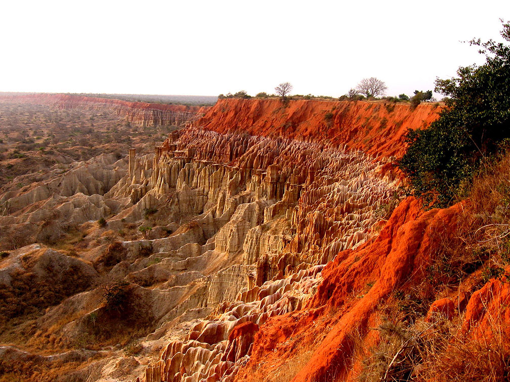 Miradouro da Lua, (watchpoint or valley of the moon), a set of cliffs situated at the coast 40 km south of Luanda. Image: Paulo César Santos |
Angola NewsAccording to BBC, the state controls all media with nationwide reach, including radio, the most influential medium outside the capital.AngolaPress (ANGOP) AngolaPress Agency is the official news agency of the state of Angola. Agora National and international news. Jornal de Angola Angola's only daily newspaper is staterun (in Portuguese) Angola News WorldNews Network (WN) powered Angolan news. TV/Radio Televisao Popular de Angola (TPA) National broadcaster. |
Bookmark/share this page |
Arts & CultureArt & Culture of Angola The Art and Style of Angola. e.studio Article about the cultural initiative and artist collective e.studio, based in Luanda. Operation Noah's Ark The Kissama Foundation, along with the Angolan government, is relocating 150 elephant and eight other species of game from Namibia and Botswana to Quiçama National Park, Angola. |
Business & EconomyAngola's high growth rate in recent years was driven by high international prices for its oil. Angola became a member of OPEC in late 2006. Oil production and its supporting activities contribute about 85% of GDP and diamond exports contribute an additional 5%.Subsistence agriculture provides the main livelihood for most of the people, but half of the country's food is still imported. Despite a postwar reconstruction boom, much of the country's infrastructure is still damaged or undeveloped from the 27-year-long civil war. Direcção Nacional do Comércio Interno Ministry of Commerce provides information on commercial reforms, legislation and developments in Angola. (in Portuguese) Ministério da Indústria Ministry of Industry. (in Portuguese) Banco Nacional de Angola (BNA) National Bank of Angola. SONANGOL Angola's National Oil Company __Transportation Airline TAAG - Linhas Aereas de Angola Angola Airlines, the national carrier. |
 The Lucala River at Kalandula Falls (Quedas de Kalandula) in Malanje Province, Angola. The falls are about 105 meters high and about 400 meters wide. They are one of the largest waterfalls by volume in Africa. Image: L. Willms Travel and Tour Consumer Information
Destination Angola: travel and tourism guidesAngola The Official Web Site of the Republic of Angola (the site is sometimes down). Pure & Authentic Tourism An Angolan travel agency. Travel Advice Regularly updated travel advice provided by the governments of various countries. |
EducationUniversidade Agostinho Neto The home page for Angola's Agostinho Neto University. Universidade Catolica de Angola Home page of the university. (in Portuguese) |
Environment & NatureUNDP in Angola - Energy and Environment The United Nations Development Programme in Angola, creates and supports partnerships to fight poverty and leads in advice, advocacy and resources to empower the poor. |
HistoryAngola History Timeline by AfricaNet. History Summary of Angola's history by the Embassy of Angola, Washington, DC.. Key events in Angola's recent history Reuters timline of Angola's recent history. History of Angola From Precolonial history to independent Angola, Wikipedia entry about the country's history. |
Sources and additional Information about AngolaAmnesty International: Angola BBC Country profile: Angola Freedom House: Angola globalEDGE: Angola Human Rights Watch: Angola OEC: Angola |
 |
One World - Nations Online .:. let's care for this planet Promote that every nation assumes responsibility for our world. Nations Online Project is made to improve cross-cultural understanding and global awareness. More signal - less NOISE |
| Site Map
| Information Sources | Disclaimer | Copyright © 1998-2024:: nationsonline.org |
