
|
Home |
|
|
|
___ Political Map of Kenya |
|
Kenya is a country in East Africa, bordering the Indian Ocean in south east, neighboring countries are Ethiopia, Somalia, South Sudan, Tanzania, and Uganda. With an area of 580,000 km², the country is somewhat larger than Metropolitan France or slightly more than twice the size of the U.S. state Nevada. Kenya has a population of 43 million people (2014). Spoken languages are Swahili and English (both official), and numerous indigenous languages mainly Kikuyu and Luhya. Largest and most populous city and the national capital of Kenya is Nairobi. Second largest city and the country's chief port is Mombasa. Kenya's climate varies from tropical along the coast to arid in interior. Kenya's landscape varies from low plains near its coast at the Indian Ocean, to a fertile plateau in west. The country's interior is dominated by the central highlands with the country's highest point Mount Kenya at 5,199 m. The highlands are bisected by the Great Rift Valley, a large natural depression that runs through Kenya with a north to south orientation, within the Valley is a chain of volcanoes, some of them are still active. North of the Kenyan Rift Valley lies Lake Turkana, formerly known as Lake Rudolf. It is the world's largest permanent desert lake. The Lake Turkana area is regarded by many anthropologists as the cradle of humankind due to the abundance of hominid fossils. Map is showing Kenya and the surrounding countries with international borders, the national capital Nairobi, province capitals, cities, main roads, railroads and major airports. |
 Bookmark/share this page |
 One World - Nations Online all countries of the world |
|
|
||
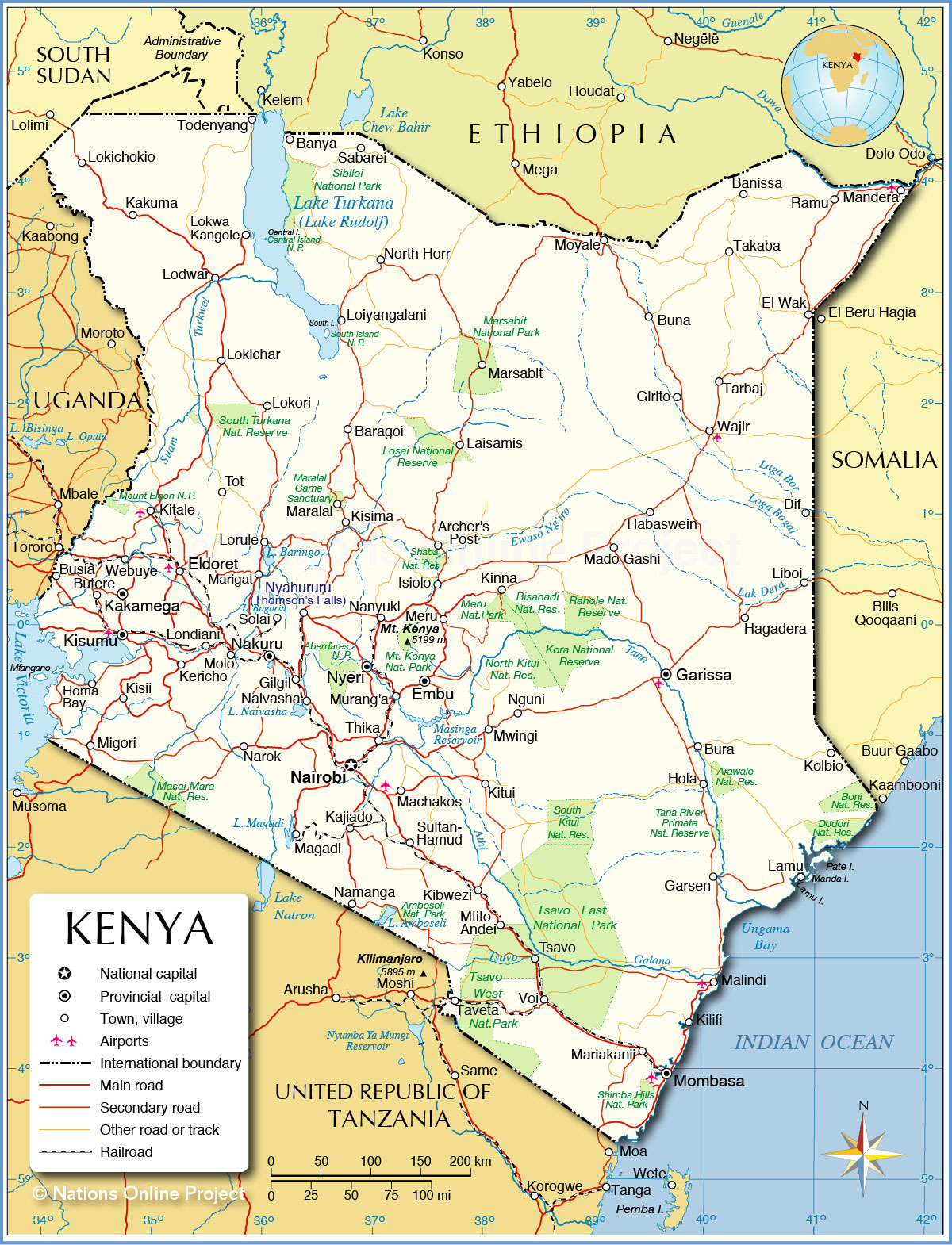 Political Map of Kenya Map based on a UN map. Source: UN Cartographic Section | |||||||
| Cities and towns in Kenya Map shows the location of following cities and towns in Kenya: Archer's Post, Banissa, Banya, Baragoi, Buna, Bura, Busiaezi, Butere, Dif, El Wak, Eldoret (pop. 200,000; has a large market and is home to the Moi University and Eldoret International Airport, IATA code: EDL), Embu, Garissa, Garsen, Gilgil, Girito, Habaswein, Hagadera, Hola, Homa Bay, Isiolo, Kajiado, Kakamega, Kakuma, Kericho, Kibw, Kilifi, Kinna, Kisii, Kisima, Kisumu (third largest city in Kenya; pop. 400,000), Kitale, Kitui, Kolbio, Laisamis, Lamu, Liboi, Lodwar, Loiyangalani, Lokichar, Lokichokio, Lokori, Lokwa Kangole, Londiani, Lorule, Machakos, Mado Gashi, Magadi, Malindi (Tourism city at Malindi Bay), Mandera, Maralal, Mariakanii, Marigat, Marsabit, Meru, Migori, Molo, Mombasa (major port and second-largest city in Kenya), Moyale, Mtito Andei, Murang'a, Mwingi, Nairobi (capital city), Naivasha, Nakuru (capital of Kenya's Rift Valley province; pop. 300,000), Namanga, Nanyuki, Narok, Nguni, North Horr, Nyahururu (Thomson's Falls), Nyeri, Ramu, Sabarei, Solai, Sultan-Hamud, Takaba, Tarbaj, Taveta, Thika, Todenyang, Tot, Tsavo, Voi, Wajir, and Webuye. |
More about Kenya: Cities: Country: Kenya key statistical data. Continent: |
Current Weather Conditions Nairobi:
|
Explore More:
Related Consumer Information:
|
||||
Maps of other Countries in East Africa Burundi Map | Comoros Map | Djibouti Map | Eritrea Map | Ethiopia Map | Kenya Map Madagascar Map | Malawi Map | Mozambique Map | Réunion Map | Rwanda Map | Somalia Map | Tanzania Map Uganda Map | Zambia Map | Zimbabwe Map Interactive Maps of other Countries in East Africa Burundi Interactive Map | Comoros Interactive Map | Djibouti Interactive Map | Eritrea Interactive Map Ethiopia Interactive Map | Kenya Interactive Map | Madagascar Interactive Map | Malawi Interactive Map Mauritius Interactive Map | Mozambique Interactive Map | Réunion Interactive Map | Rwanda Interactive Map Seychelles Interactive Map | Somalia Interactive Map | Tanzania Interactive Map | Uganda Interactive Map Zambia Interactive Map | Zimbabwe Interactive Map Major Cities in East Africa Addis Ababa, Antananarivo, Asmara, Bujumbura, Dar es Salaam, Djibouti, Dodoma, Harare, Kampala, Kigali, Lilongwe, Lusaka, Maputo, Moroni, Mogadishu, Nairobi, Port Louis, Victoria, Zanzibar |
|||||||
One World - Nations Online .:. let's care for this planet Every nation is responsible for the current state of our world. |
| Site Map
| Information Sources | Disclaimer: Privacy Policy, etc. Contact: [email protected] | Copyright © 1998-2021 :: nationsonline.org |
