Nations Online
All Countries in the World
Nations Online All Countries in the World | |
Home  |
___ Map and Satellite View of Angola |
Searchable Map and Map and Satellite View of Angola using Google Earth DataSatellite view is showing Angola on the west coast of Africa bordering the Atlantic Ocean.Capital City of Angola is Luanda with a population of 2.8 million people. Spoken languages are Portuguese (official), and several Bantu languages. Border countries: Democratic Republic of the Congo (former Zaire), Republic of the Congo, Namibia, and Zambia. The map shows Angola with cities, towns, expressways, main roads and streets. To find a location in Angola use the form below. |
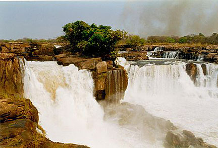 Tazua Falls on Cuango River in Angola. - Image: Brian Harrington Spier |
| To find a location type: street or place, city, optional: state, country. |
Local Time Angola:
Wednsday-April-24 01:52
Time zone: West Africa Time (WAT) :: UTC/GMT +1 hours |
|
φ Latitude, λ Longitude (of Map center; move the map to see coordinates): , |
||||||
| Google Maps: Searchable Map of República de Angola. |
Bookmark/share this page |
|||||
| More about Angola: Cities: Country: Continent: |
Current Weather Conditions Luanda
|
Related Consumer Information:
|
||||
Map Help [ show ] |
||||||
One World - Nations Online .:. let's care for this planet Promote that every nation assumes responsibility for our world. Nations Online Project is made to improve cross-cultural understanding and global awareness. More signal - less NOISE |
| Site Map
| Information Sources | Disclaimer | Copyright © 1998-2023 :: nationsonline.org |

