Nations Online
All Countries in the World
Nations Online All Countries in the World | |
Home  |
___ Satellite View and Map of the City of São Tomé, São Tomé and Príncipe |
Satellite View of São Tomé using Google Earth DataSatellite view is showing the city of São Tomé, the national capital of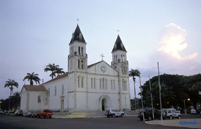 Sé Cathedral at São Tomé city. Image: Kotowski The map shows a city map of São Tomé with expressways, main roads and streets, zoom out to find the location of São Tomé International Airport (IATA code: TMS) situated in a distance of about 6 km (4 mi) by road northwest of the city center. To find a location use the form below. |
|
| To find a location type: street or place, city, optional: state, country. |
Local Time São Tomé and Príncipe:
Wednsday-April-24 13:32
No UTC/GMT offset |
|
φ Latitude, λ Longitude (of Map center; move the map to see coordinates): , |
||||||
| Google Maps: Searchable map/satellite view of the City of São Tomé, capital of the Democratic Republic of Sao Tome and Principe. City Coordinates: 0°20′10″N 6°40′53″E |
Bookmark/share this page |
|||||
| More about São Tomé and Príncipe: Country: Continent: External Link: Wikipedia: São Tomé |
São Tomé Weather Conditions
|
Related Consumer Information:
|
||||
Other Capital Cities in West Africa Abuja, Accra, Bamako, Banjul, Bissau, Conakry, Dakar, Freetown, Lomé, Monrovia, Niamey, Nouakchott, Ouagadougou, Porto-Novo, Praia, Yamoussoukro Searchable Maps of Countries in West Africa: Benin | Burkina Faso | Cape Verde | Côte d'Ivoire | Gambia | Ghana | Guinea | Guinea-Bissau Liberia | Mali | Mauritania | Niger | Nigeria | Senegal | Sierra Leone | Togo |
||||||
Map Help [ show ] |
||||||
One World - Nations Online .:. let's care for this planet Promote that every nation assumes responsibility for our world. Nations Online Project is made to improve cross-cultural understanding and global awareness. More signal - less NOISE |
| Site Map
| Information Sources | Disclaimer | Copyright © 1998-2023 :: nationsonline.org |

