
| Home |
|
|
|
___ Administrative Map of Gabon |
|
About Gabon |
|
Map is showing Gabon, a country at the Equator in West-Central Africa bordering the Atlantic Ocean in west. Gabon is bordered by Equatorial Guinea, Cameroon, and the Republic of the Congo. With an area of 267,668 km², the country is somewhat larger than the United Kingdom, or slightly smaller than the U.S. state of Colorado. Because of its oil and mineral reserves and a relatively small population, Gabon is one of Africa's wealthier nations, and therfore the country is able to maintain and conserve its pristine rain forests with their rich biodiversity. Tropical rainforests covering 85% of the territory, more than 10% of Gabon's area is protected parkland, there are 13 National Parks in the country. Among them the forested coastal terrain of the Loango National Park. 'Africa's Last Eden', shelters a broad diversity of wildlife from gorillas and hippos to whales. Lopé National Park consists of mostly rainforest, but in in the north the park contains the last remnants of grass savannas. Akanda Park is known for its mangroves and tidal beaches. Highest mountain in Gabon is Mont Iboundji with 1,575 m. The country has a population of 1.5 million people. Gabon's national capital is Libreville. Spoken languages are French (official) and West African languages most notably Fang, and Myene. |
 Bookmark/share this page |
 One World - Nations Online All Countries of the World |
|
|
||
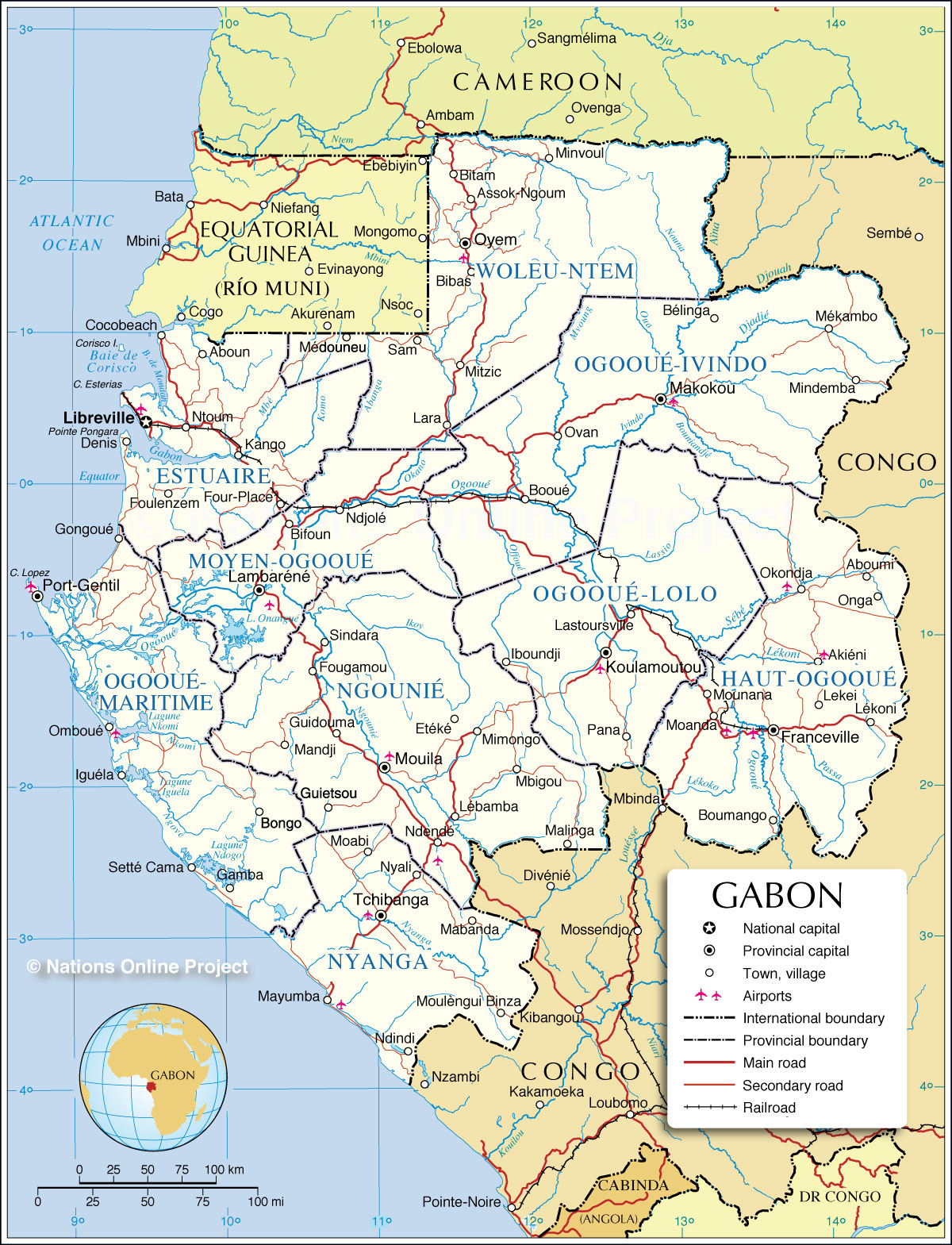 Administrative Map of Gabon Map based on a UN map. Source: UN Cartographic Section | |||||||
| Administrative Regions of the Gabonese Republic Gabon is divided into nine provinces and further divided into 37 departments. The provinces are, in alphabetical order, (province capital in parenthesis): Estuaire (Libreville), Haut-Ogooué (Franceville), Moyen-Ogooué (Lambaréné), Ngounié (Mouila), Nyanga (Tchibanga), Ogooué-Ivindo (Makokou), Ogooué-Lolo (Koulamoutou), Ogooué-Maritime (Port-Gentil), Woleu-Ntem (Oyem) |
More about Gabon: Cities: Country: Continent: |
Libreville Current Weather Conditions
|
Related Consumer Information:
|
||||
| Maps of other Countries in Central Africa Angola Map | Cameroon Map | Central African Republic Map | Chad Map | Republic of the Congo Map Democratic Republic of the Congo Map | Equatorial Guinea Map Maps of other Countries in West Africa: Benin Map | Cape Verde Map | Côte d'Ivoire Map | Ghana Map | Guinea Map | Guinea-Bissau Map Liberia Map | Mali Map | Mauritania Map | Niger Map | Nigeria Map | Senegal Map | Sierra Leone Map | Togo Map |
|||||||
One World - Nations Online .:. let's care for this planet Every nation is responsible for the current state of our world. |
| Site Map
| Information Sources | Disclaimer: Privacy Policy, etc. Contact: [email protected] | Copyright © 1998-2021 :: nationsonline.org |
