
|
Home |
|
|
|
___ Political Map of Malawi |
|
| Malawi is a landlocked country in southern central Africa in the Great Rift Valley, on the western shore of Lake Nyasa. Lilongwe is its capital city. With an area of 118,484 km², Malawi is slightly smaller than Nicaragua or a little bigger than Eritrea. Official languages are English and Nyanja (also known as Chichewa). Map is showing Malawi and the surrounding countries with international borders, the national capital, regions and districts capitals, cities, main roads, railroads and major airports. Administrative Regions of Malawi. Malawi is divided into the the Northern region, the Central region and the Southern region, the country is further divided into twenty-seven districts, namely: Balaka | Blantyre | Chikwawa | Chiradzulu | Chitipa | Dedza | Dowa | Karonga | Kasungu | Likoma | Lilongwe | Machinga | Mangochi | Mchinji | Mulanje | Mwanza | Mzimba | Neno | Nkhata Bay | Nkhotakota | Nsanje | Ntcheu | Ntchisi | Phalombe | Rumphi | Salima | Thyolo | Zomba Border Countries: Mozambique, Tanzania, Zambia |
 Bookmark/share this page |
 One World - Nations Online All Countries of the World |
|
|
||
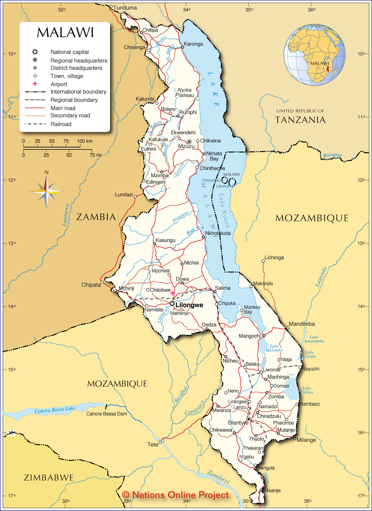 Political Map of Malawi Map based on a UN map. Source: UN Cartographic Section | |||||||
| Map shows the location of following cities and villages in Malawi Balaka, Bangula, Blantyre, Bolero, Chikwawa, Chikwina, Chilobwe, Chintheche, Chipoka, Chiradzulu, Chisenga, Chitipa, Dedza, Domasi, Dowa, Edingeni, Ekwendeni, Euthini, Kafukule, Karonga, Kasungu, Katumbi, Lanzu, Lilongwe, Lirangwe, Liwonde, Machinga, Makanjila, Mangochi, Mchinji, Monkey Bay, Mponela, Mulanje, Mwanza, Mzimba, Mzuzu, N'gabu, Namadzi, Nambazo, Namitete, Nathenje, Nayuchi, Neno, Nkhata Bay, Nkhotakota, Nsanje, Ntaja, Ntcheu, Ntchisi, Phalombe, Rumphi, Salima, Thekerani, Thyolo, and Zomba. |
More about Malawi: Cities: Country: Continent: | Lilongwe Current Weather Conditions
|
Related Consumer Information:
|
||||
Maps of other Countries in East Africa Burundi Map | Comoros Map | Djibouti Map | Eritrea Map | Ethiopia Map | Kenya Map Madagascar Map | Malawi Map | Mozambique Map | Réunion Map | Rwanda Map | Somalia Map | Tanzania Map Uganda Map | Zambia Map | Zimbabwe Map Interactive Maps of other Countries in East Africa Burundi Interactive Map | Comoros Interactive Map | Djibouti Interactive Map | Eritrea Interactive Map Ethiopia Interactive Map | Kenya Interactive Map | Madagascar Interactive Map | Malawi Interactive Map Mauritius Interactive Map | Mozambique Interactive Map | Réunion Interactive Map | Rwanda Interactive Map Seychelles Interactive Map | Somalia Interactive Map | Tanzania Interactive Map | Uganda Interactive Map Zambia Interactive Map | Zimbabwe Interactive Map Major Cities in East Africa Addis Ababa, Antananarivo, Asmara, Bujumbura, Dar es Salaam, Djibouti, Dodoma, Harare, Kampala, Kigali, Lilongwe, Lusaka, Maputo, Moroni, Mogadishu, Nairobi, Port Louis, Victoria, Zanzibar | |||||||
One World - Nations Online .:. let's care for this planet Every nation is responsible for the current state of our world. |
| Site Map
| Information Sources | Disclaimer: Privacy Policy, etc. Contact: [email protected] | Copyright © 1998-2021 :: nationsonline.org |
