Nations Online
All Countries in the World
Nations Online All Countries in the World | |
Home  |
___ Satellite View and Map of the City of Moroni, Comoros |
About Moroni Satellite view is showing Moroni, a port, largest city and the national capital (since 1962) of Satellite view is showing Moroni, a port, largest city and the national capital (since 1962) of Moroni is located at the foot of Mount Karthala, an active volcano, on the western coast of Ngazidja island better known as Grande Comore. Moroni has a population of about 55,000 inhabitants. Spoken languages are Comorian, the "language of islands", Arabic and French. The city is the seat of the government of the Comoros. It is also home to the National Museum, the National Archive, and the National Library of the Comoros. The map shows a city map of Moroni with expressways, main roads and streets, zoom out to find the location of Moroni Hahaya Airport (Prince Said Ibrahim International Airport) (IATA code: HAH) 22 km by road (via RN 1) north of the city. To find a location use the form below. |
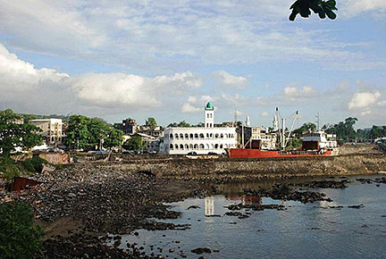 Moroni Port Image: Sascha Grabow Bookmark/share this page |
| To find a location type: street or place, city, optional: state, country. |
Local Time Comoros:
Monday-June-29 19:29
East Africa Time (EAT) :: UTC/GMT +3 hours |
One World - Nations Online .:. let's care for this planet Promote that every nation assumes responsibility for our world. Nations Online Project is made to improve cross-cultural understanding and global awareness. More signal - less NOISE |
| Site Map
| Information Sources | Disclaimer | Copyright © 1998-2024:: nationsonline.org |

