One World
Nations Online
One World Nations Online |
|
| Home |
___ Cameroon |
 Municipal Lake in Yaoundé's Lake Quarter with the Ministry of Posts and Telecommunications - MINPOSTEL (right). The capital city of Cameroon has a population of approximately 3 million people (in 2019), it is the country's second largest city after the port city of Douala. Image: Frederic Papy |
 Location map of Cameroon With an area of 475,650 km², the country is almost as large as Spain or slightly larger than the US state of California. Its southern and coastal areas are characterized by dense vegetation, a vast river system and a hot, humid climate with abundant rainfall. Largest city is Douala, the country's main port and economic capital with its commercial and industrial activities, Yaounde is the second largest city and the political capital of Cameroon. Other major urban centers are Edea, characterized by its heavy industry and its hydro-power plant, Limbe, headquarters of the oil industry and Kribi terminal of the Chad-Cameroon pipeline. Cameroon has a population of 29 million people (in 2024), English and French are official languages, however French is by far the most commonly used language. |
Republic of Cameroon | Republique du Cameroun |
Country Profile |
Background: The name Cameroon is derived from the Portuguese word, Camaroes, meaning shrimps. As Portuguese sailor Ferdanando Poo arrived in 1472 at the Wouri river in Douala and discovered so many shrimps in the river he decided to call it Rio Dos Camaroes (River of shrimps, in Portuguese). It was from this word that the territory derived its name which is now spelt in various forms: Spanish spelt it Cameroes; Germans, Kamerun; English, Cameroon; and French, Cameroun. The territory was colonized by the Germans in 1884 but after the end of the First World War Cameroon was mandated by the League of Nations to the French and British governments. France took the greater sector, formally known as East Cameroon, while Britain took responsibility over former West Cameroon known then as "Cameroon under British Administration". On January 1st 1960 the French Sector became independent under the new name of Cameroon Republic. Following agitation for independence by the Southern Cameroons - before the name was changed to West Cameroon - a plebiscite was held in that sector of Cameroon on February 11th 1961 under the United Nations supervision. The result of the plebiscite was overwhelming for reunification (233,571 against 97,741) and gave Southern Cameroon automatic independence and unification, which was achieved on 1 October 1961. Thus after the reunification of both sectors, the Federal Republic of Cameroon was born. After a referendum in May 1972, Cameroon became a United Republic and by a Presidential Decree of 1984 it became the Republic of Cameroon. (Source: Cameroon Embassy in the Netherlands) Related countries: France, Germany, United Kingdom |
Official Names: Republique du Cameroun (fr) Republic of Cameroon (eng) short form: Cameroun/Cameroon formerly: French Cameroon, British Cameroon, Federal Republic of Cameroon, United Republic of Cameroon ISO Country Code: cm Time: Local Time = UTC +1h Actual Time: Thu-June-11 06:30 Country Calling Code: +237 Capital City: Yaounde (pop. 1.1 million) Other Cities: Douala, major seaport and commercial capital (1.3 million), Garoua (424,312), Maroua (409,546), Bafoussam (319,457), Bamenda (321,490), Nkongsamba (166,262), and Ngaoundere (216,300). Government: Republic; with a strong central government dominated by president. Independence: 1 January 1960 (for areas formerly ruled by France) and 1 October 1961 (for territory formerly ruled by Britain). Constitution: 2 June 1972, last amended in January 1996. Geography: Location: Central West Africa bordering the Bight of Biafra (part of the Gulf of Guinea and the Atlantic Ocean) Area: 475,650 km² (183,650) sq. mi.). Terrain: Northern plains, central and western highlands, southern and coastal tropical forests. Highest peak: Mt. Cameroon (13,353 ft.). Climate: Northern plains, the Sahel region--semiarid and hot (7-month dry season); Central and western highlands where Yaounde is located--cooler, shorter dry season; southern tropical forest--warm, 4-month dry season; Coastal tropical forest, where Douala is located--warm, humid year-round. People: Nationality: Cameroonian(s); French noun and adjective--Camerounais(e). Population: 29,1 million (in 2024) Ethnic groups: About 250. Religions: Christian 53%, Muslim 22%, indigenous African 25%. Languages: French and English (both official) and about 270 African languages and dialects, including pidgin, Fulfulde, and Ewondo. Literacy: 75% Transparency: Rank 149 (out of 180 countries); Score 25, on a scale from 100 (very clean) to 0 (highly corrupt). Cameroon is ranked in the Corruption Perceptions Index 2020 between Uzbekistan and Guatemala. Real GDP per capita: $4,800 (2023 est.) Natural resources: Oil, timber, hydroelectric power, natural gas, cobalt, nickel. Agriculture products: timber, coffee, tea, bananas, cocoa, rubber, palm oil, pineapples, cotton. Industries: Petroleum production and refining, aluminum production, food processing, light consumer goods, textiles, lumber, ship repair Exports - commodities: crude oil and petroleum products, lumber, cocoa beans, aluminum, coffee, and cotton. Exports partners: Netherlands 19%, France 15%, India 14%, Spain 10%, China 8% (2022) Imports - commodities: machinery, electrical equipment, transport equipment, fuel, food, cereals, fish. Imports partners: China 39%, France 8%, India 6%, Belgium 4%, UAE 4% (2022) Currency: Communaute Financiere Africaine franc (XAF) |
|
Note: External links will open in a new browser window. Official Sites of CameroonPresidence de la Republique du CamerounThe Presidency of the Republic of Cameroon at Unity Palace. Prime Minister's Office Kind of outdated official website of the Prime Minister and a government gateway site. Assemblée Nationale du Cameroun (dead link) Cameroon's National Assembly. Ministère des Relations Extérieures du Cameroun (MINREX) Official website of the Ministry of Foreign Affairs of Cameroon. Diplomatic Missions Embassy of the Republic of Cameroon Washington, DC, USA. Cameroon Embassy Official Website Embassy of Cameroon in The Hague, Netherlands. Statistics Institut National de la Statistique du Cameroun National Institute of Statistics of Cameroon. Weather Météorologie Nationale du Cameroun National Meteorological Service Cameroun. MapsPolitical map of Cameroon. Map showing Cameroon's administrative regions. Searchable map and satellite view of Cameroon. Searchable map and satellite view of Cameroon's capital city. Political Map of Africa. Political Map of West Africa. 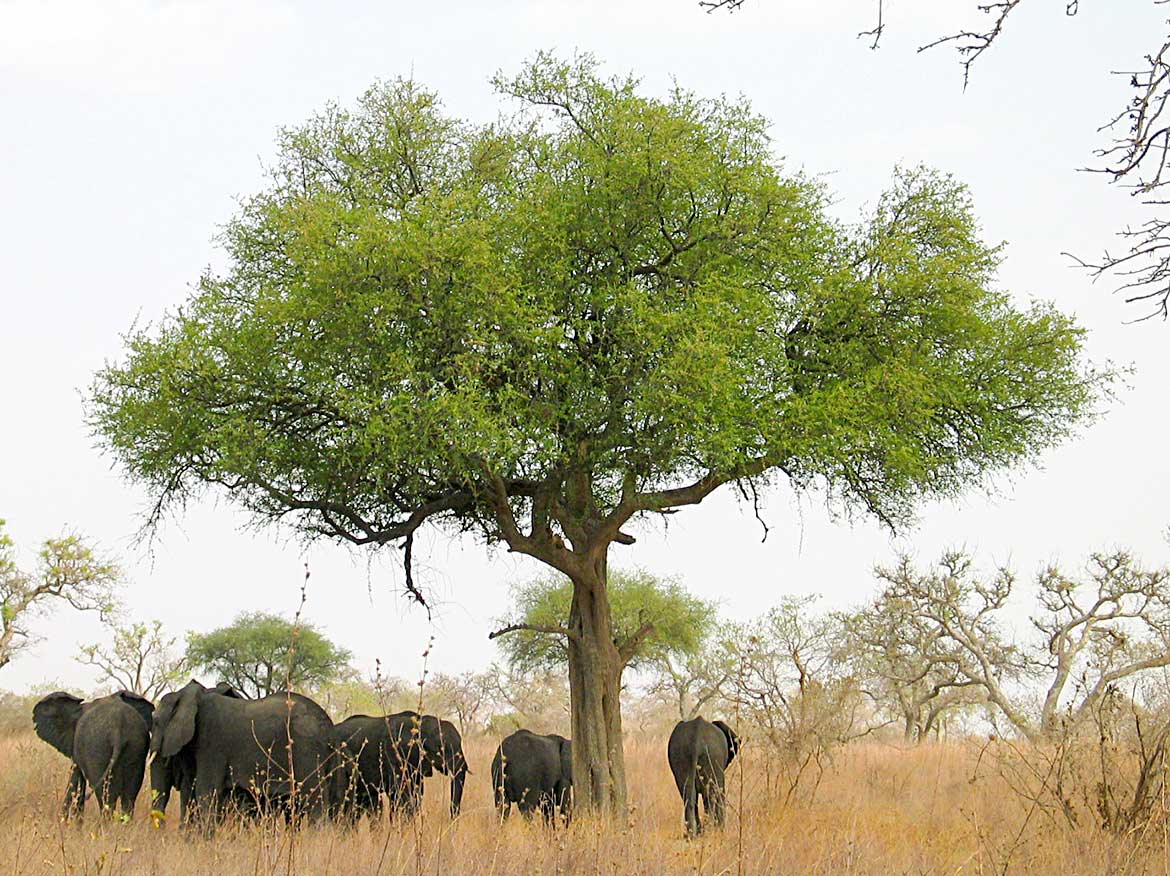 Elephants in Waza National Park in Far North Region of Cameroon. Image: Amcaja |
NewsAlthough Cameroon has one of the richest media landscapes in Africa, it is one of the continent's most dangerous countries for journalists, who operate in a hostile and precarious environment. (RSF).Cameroon News (in French) Cameroon-Info.Net Local and international news. Camerounlink News portal website. Cameroon Tribune State-owned daily. English-language News CameroonOnline.ORG Cameroon news portal. The Guardian Post English language daily news from Cameroon The Sun Cameroon news in English-language. Radio/TV Cameroon Radio Television (CRTV) State run station. |
Arts & Culture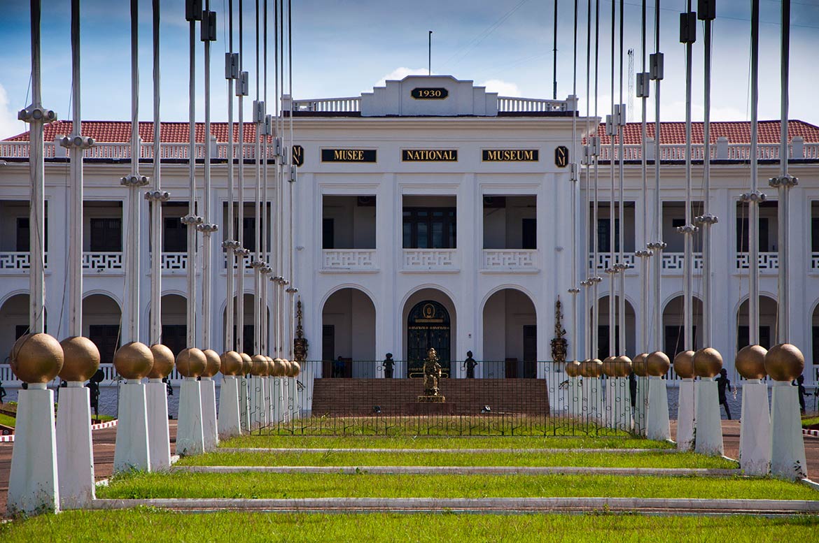 The National Museum of Yaounde is Cameroon's National Museum, situated in the former palace that was home of many French governors and later the president of Cameroon, the palace was built in the colonial era. The museum exhibits cultural symbols of Cameroon like traditional masks, arms, and musical instruments, as well as contemporary art. - Image: Z. NGNOGUE The National Museum of Yaounde MOMA page about Cameroon's National Museum and its traditional African art collections. Native Bakweri (or Kwe) people Wikipedia article about the Bakweri society and culture. Baka Pygmies Culture, music and rites of initiation of the hunters and gatherers of the Central African rainforest. Sports Cameroon national football team Official website of Cameroon's national soccer team. |
|
Business & EconomyBecause of its oil resources and favorable agricultural conditions, Cameroon has one of the best-endowed primary commodity economies in sub-Saharan Africa. Still, it faces many serious problems such as stagnant per capita income, a relatively inequitable distribution of income, a top-heavy civil service, endemic corruption, and a generally unfavorable climate for business enterprise.Banque Centrale des Etats d'Afrique Centrale - BEAC Central Bank of Cameroon, Chad, Central African Republic, Congo, Equatorial Guinea and Gabon. IZF.net, le portail de la Zone Franc CFA Information about business and investment in the Western African countries within the monetary system of the Franc Zone - CFA. (in French) Index of Economic Freedom: Cameroon Summary about Cameroon's economy by The Heritage Foundation. Transportation Cameroon Airlines Corporation Camair-Co is serving as the flag carrier of the country, it operates out of Douala International Airport. Cameroon Airlines was Cameroon's flag carrier, it operated flights in Southern Africa and to France. The company ceased operations in 2008. |
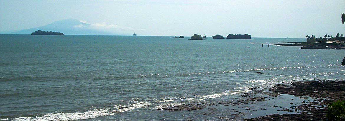 Shore at Limbe, Southwest Province, Cameroon, with Bioko island (Equatorial Guinea) visible in the distance. Image: Amcaja Travel and Tour Consumer Information
Destination Cameroon - Travel and Tour GuidesDiscover Cameroon: 'All of Africa in a single Country' or 'Africa in miniature'. Mount Cameroon, Dja Faunal Wildlife Reserve, Waza National Park accommodation, hotels, attractions, festivals, events, tourist boards, tours and much more. Ministry of Tourism Discover Cameroon. Visit Cameroon About tourism in Cameroon. Tourist Attractions Cameroon's tourist attractions by the Embassy of the Republic of Cameroon. Discover Cameroon Cameroon tour guide by Discover Afrika. Cameroon Travel and Tours Cameroon tour operator. www.cameroon-tour.com A guide to Cameroon. Cameroon World Heritage Sites Dja Faunal Reserve One of the largest and best-protected rainforests in Africa is a UNESCO World Heritage Site. The reserve is especially noted for its biodiversity and a wide variety of primates. Sangha Trinational Three contiguous national parks of about 750,000 ha in the north-western Congo Basin, where Cameroon, Central African Republic and Congo meet. cameroun-plus.com French language Cameroon directory and portal site with comprehensive information about the nation. Cameroun / Cameroon Wikimedia Commons pages with images of Cameroon. |
EducationASOY American School of Yaoundé Founded in 1964 primarily for children of American diplomats but it also serves students from all nationalities and religious groups. Universities University of Douala The University of Douala is located in Cameroon's largest city, Douala. Université de Yaoundé I and Université de Yaoundé II - SOA The Universities of Yaounde are leading institutions of higher education in Cameroon, they will represent one of the five campuses of the new Pan African University (PAU), founded in 2011. (in French) List of universities in Cameroon Wikipedia's list of universities in Cameroon.. |
Environment & NatureCentre pour l'Environnement et le Développement -Yaoundé (dead link) Site about the center, works on sustainable development, mainly with the rural population of the forest zone. Limbe Wildlife Centre Limbe Wildlife Centre (LWC) is a wildlife rescue and rehabilitation project in the South West Region of Cameroon. Government Agencies Ministere des Forêts et de la Faune (MINFOF) Ministry of Forests and Wildlife, Cameroon (in French). Ministère de l'Environnement et de la Protection de la Nature (MINEP) Ministry of Environment and Nature Protection (in French). |
HistoryCameroon History Wikipedia article about Cameroon's History until today. Colonial Picture Archive Keyword searchable database of photographs from the German colonial history, the archive covers Namibia, Tanzania, Cameroon, Togo, and other former German colonies. |
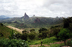 Rhumsiki landscape in the Far North Province |
Other Countries of Central Africa Angola, Central African Republic, Chad, Democratic Republic of the Congo (Kinshasa), Republic of the Congo (Brazzaville) Equatorial Guinea, Gabon, São Tomé and Príncipe |
One World - Nations Online .:. let's care for this planet Promote that every nation assumes responsibility for our world. Nations Online Project is made to improve cross-cultural understanding and global awareness. More signal - less NOISE |
| Site Map
| Information Sources | Disclaimer | Copyright © 1998-2024:: nationsonline.org |