One World
Nations Online
One World Nations Online |
|
| Home |
|
___ Eritrea |
|
 Highlands between Asmara and Massawa. Image: Hansueli Krapf |
|
 Flag of Eritrea  Location map of Eritrea The former Italian colony became part of a federation with Ethiopia in 1947, in 1952 Eritrea was annexed by Ethiopia. The country became independent in 1993. The country's landscape is divided into three ecological distinct regions. There are the Eritrean highlands, the northern extention of the Ethiopian Plateau, running north to south through the center of the country, the hot and dry western lowlands, and the coastal plain. Highest point is Emba Soira at 3,018 m. With an area of 117,000 km², the country is almost four times the size of Belgium or slightly larger than the U.S. state of Pennsylvania. Capital and largest city is Asmara situated on the northwestern edge of the Eritrean highlands. Other important cities are the ports of Massawa and Assab. The country's population of 6 million people is made up of Tigrayans (55%), Tigre people (30%) and some smaller ethnic groups, like Saho, and Kunama. Spoken languages are Tigrinya, Arabic, and English. About 50% of the population are Christians, 48% adheres to Islam. |
|
State of Eritrea | Hagere Ertra |
Country Profile |
Background: Eritrea is located in Eastern Africa in the Horn of Africa, to the North of Ethiopia and bordering the Red Sea in Northeast. It has a mixed Afro-Asiatic population that is divided by religion and language. The former Italian and British colony gained formal independence from Ethiopia, its last colonizer, in 1993. But independence did not end the wars in Eritrea. Conflicts with Yemen and Ethiopia followed. Latest UN Inquiry (2015) reports gross human rights violations in Eritrea. The Government of Eritrea is responsible for systematic, widespread and gross human rights violations that have created a climate of fear. A large proportion of the population is subjected to forced labour and imprisonment, and hundreds of thousands of refugees have fled the country. |
Official Name: Hagere Ertra short form: Ertra int'l long form: State of Eritrea int'l short form: Eritrea former: Eritrea Autonomous Region in Ethiopia. ISO Country Code: er, ERI Time: Local Time = UTC +3h Actual Time: Fri-Apr-26 04:11 Country Calling Code: +291 Capital City: Asmara (2,300 meters (7,500 ft.) above sea level; pop. 435 000) Other Cities: Keren (57,000); Assab (28,000); Massawa (25,000); Afabet (25,000); Tessenie (25,000); Mendefera (25,000); Dekemhare (20,000); Adekeieh (15,000); Barentu (15,000); Ghinda (15,000). Government: Single-party presidential republic. In 2004 the U.S. State Department declared Eritrea a Country of Particular Concern (CPC) for its alleged record of religious persecution. Independence: Eritrea officially celebrated its independence on May 24, 1993 (from Ethiopia) Constitution: Ratified 24 May 1997, but not yet implemented. Geography: Location: Eastern Africa, in the Horn of Africa bordering the Red Sea in northeast. Area: 117,600 km². (45,405 sq. mi.) Terrain: Central highlands straddle escarpment associated with Rift Valley, dry coastal plains, and western lowlands. Climate: Temperate in the mountains and hot in the lowlands, hot, dry desert strip along Red Sea coast;. People: Nationality: Noun and adjective--Eritrean(s). Population: 6 million (about 1 million Eritreans in exile). Ethnic Groups: Tigrinya 50%, Tigre 31.4%, Saho 5%, Afar 5%, Beja 2.5%, Bilen 2.1%, Kunama 2%, Nara 1.5%, and Rashaida .5%. Religions: Christian 50% (mostly Orthodox), Muslim 48%, indigenous beliefs 2% Languages: Tigrinya (Tigrigna), Arabic, English, Tigré (second major language) and other Cushitic languages. Literacy: 53% Natural resources: Gold, potash, zinc, copper, salt, possibly oil and natural gas, fish. Agriculture products: Sorghum, lentils, vegetables, corn, cotton, tobacco, coffee, sisal; livestock, goats; fish. Industries: Food processing, beverages, clothing and textiles. Exports - commodities: Copper Ore, Precious Metal Ore, Coffee, Precious Stones. Imports - commodities: Cars, Rubber Tires, Machinery, Petroleum Products, Food, Manufactured Goods. Currency: Nakfa (ERN) More Eritrea statistical data. |
Political system 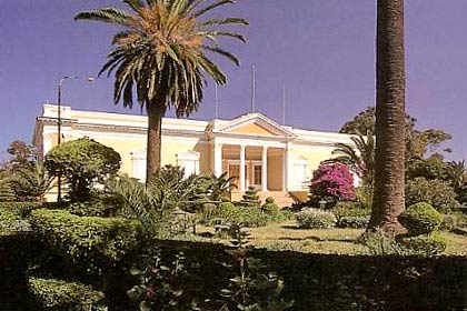 Presidential Palace, office of President Isaias Afewerki. The mansion was built in 1897 by Fernando Martini, the first Italian governor of Eritrea. At least on paper the government system of Eritrea is a presidential republic. But in practice the country is a militarized one-party state run by the People's Front for Democracy and Justice (PFDJ) with president Isaias Afewerki as the chief of state and head of government. Afewerki has been in office since independence in 1993. Other political groups are not allowed to organize, although the unimplemented constitution of 1997 provides for the existence of multi-party politics. National elections have been periodically scheduled and cancelled; none have ever been held in the country. The US has Eritrea designated as a Country of Particular Concern. A United Nations report Official Sites of EritreaNote: External links will open in a new browser window.The State of Eritrea - Ministry of Information As it should, the Ministry provides information on Eritrea like national news, and information on history, culture and arts. Missions The Permanent Mission of the State of Eritrea to the United Nations Eritrea's representation at the UN. Embassy of Eritrea in Washington D.C. Embassy of Eritrea to the U.S. Embassy of Eritrea, Stockholm Embassy of Eritrea to Sweden. Embassy of the State of Eritrea, New Delhi Embassy of Eritrea to India. Statistics Eritrea key statistical data. MapsPolitical Map of Eritrea. Searchable map and satellite view of Eritrea. Searchable map and satellite view of Eritrea's capital city. Political and topographic map of the Red Sea. With all 54 countries of Africa. A Relief Map of Africa.  Welcome to Asmara. Camels near Asmara, capital city of Eritrea. Image: Michael Walsh |
| Eritrea News Eritrea is the only African country to have no privately-owned news media. The news links below are to sites mostly maintained from Eritrean expatriates. See CPJ - the The Committee to Protect Journalists on press freedom in Eritrea. Eritrea, which has been led since independence by the highly authoritarian Issaias Afeworki, figures in last place on Reporters Without Borders’ world press freedom index. Alenalki "Welcome to the real Eritrean website". News Asmarino Com Eritrea News in Tigrinia and English. DEHAI Eritrean Community OnLine Network, provides up-to-date Eritrean related news from various sources. Shabait Latest news from Eritrea provided by the ruling political party, the People's Front for Democracy and Justice (PFDJ). Other News Sources The Guardian - Eritrea Eritrea related news from The Guardian. www.IRINnews.org UN humanitarian news and information service with recent news on Eritrea. |
Bookmark/share this page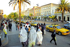 Asmara City Scene |
Arts & CultureThe people of Eritrea Some information and pictures from and about Eritrea. The Dutch photographer Anne Alders has captured the everyday life of the nine sections of the Eritrean population. |
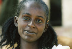 A Tigrinya woman © Anne Alders from the Book "eritrean beauty" |
 Sifting grain by hand in Eritrea. Image: David Stanley Business & EconomyCOMESA - Common Market for Eastern and Southern Africa Eritrea is a member state of COMESA, an organisation of free independent sovereign states which have agreed to co-operate in developing their natural and human resources for the good of all their people. EDF - Eritrean Development Founndation An independent non-profit humanitarian organization dedicated to supporting economic, social and cultural development in Eritrea. Invest in Eritrea A blog about investment activities in Eritera. Transportation Eritrean Airlines Eritrean Airlines is wholly owned by the Government of Eritrea. The airline was restarted under new management in 2011. |
 The Eritrean Railway was built between 1887 and 1888 by the Italians, back then the colonial power in the country. Today the train is used only for tourist services and operates between Asmara and Massawa, an important port city on the Red Sea coast. Image: Optimist on the run Travel and Tour Consumer Information
Destination Eritrea - Country GuidesEritrea at a Glance Eritrea information by the Eritrea Ministry of Tourism. Asmarino.com The Asmarino site provides articles about Eritrea (in English/Tigrigna). Very informative site about Eritrea by Hans van der Splinter and Mebrat Tzehaie. Asmara Grande Eritrea travel guide and tour guide. Wikivoyage Eritrea Travel Eritrea, tourist-related information by Wikivoyage. Eritrea travel advice The FCO advise against all travel within 25km of Eritrea’s border with its neighboring countries Ethiopia, Djibouti and Sudan. Travel advice for Eritrea by the British government. |
 Sunset at Agordat © Anne Alders from the Book "eritrean beauty" |
Education Hamelmalo Agricultural College in Keren. Image: Eritrea Ministry Of Information National Board for Higher Education Eritrean institution for higher education in the arts,sciences, business and economics, law, education, engineering, agriculture and health science. Eritrea Institute of Technology The Eritrea Institute of Technology (EIT) or Mai-Nefhi College is a technological institute located southwest of Asmara. |
Environment & NatureIGAD The Intergovernmental Authority on Development, a regional grouping of seven Eastern African countries created in 1986 to fight the recurrent and severe droughts and other natural disasters that caused widespread famine, ecological degradation and economic hardship in the Eastern Africa region between 1974 and 1984. |
 The ruins of Haile Selassie's palace on Taulud Island, Massawa, Semien-Keih-Bahri. The emperor of Ethiopia used the palace when he visited Massawa once a year. Image: Carsten ten Brink HistoryDuring the Middle Ages the region was part of the medieval Medri Bahri kingdom, which maintained important trade routes from the Ethiopian highlands to the Red Sea. Marketable goods were gold, coffee, and slaves.In the 16th century portions of the region became an Ottoman province with Massawa as its capital. The Ottomans lost foothold at the end of the century but they retained control over the coastal areas (today coastal Eritrea and Djibouti) until the establishment of Italian Eritrea in the late 1800s. The colony of the Kingdom of Italy ended in 1947. In January 1941 the British army has conquered Eritrea during its the Abyssinian Campaign, this event triggered the Italian guerrilla war in Ethiopia/Eritrea. In 1947 Eritrea became part of a federation with Ethiopia and in 1952 Eritrea was annexed by Ethiopia. The annexation led to the Eritrean War of Independence, ending with Eritrea's independence in 1993. The Eritrean–Ethiopian border conflict is still ongoing, a violent standoff with numerous casualties. History of Eritrea Eritrea from early history until now. Eritrea-Ethiopia Conflict Information Page Site provides information on the Crisis Between Eritrea and Ethiopia with maps, history, publications. History of Eritrea Wikipedia articles about Eritrea and the country's history. |
Other Countries of Central Africa Angola, Cameroon, Central African Republic, Chad, Congo, Dem. Rep. (Kinshasa), Congo, Rep. (Brazzaville), Equatorial Guinea, Gabon, São Tomé and Príncipe Other Countries of Eastern Africa Burundi, Comoros, Djibouti, Ethiopia, Kenya, Madagascar, Malawi, Mauritius, Mozambique Réunion, Rwanda, Seychelles, Somalia, Tanzania, Uganda, Zambia, Zimbabwe |
One World - Nations Online .:. let's care for this planet Promote that every nation assumes responsibility for our world. Nations Online Project is made to improve cross-cultural understanding and global awareness. More signal - less NOISE |
| Site Map
| Information Sources | Disclaimer | Copyright © 1998-2023 :: nationsonline.org |