Nations Online
All Countries in the World
|
One Planet Nations Online All Countries in the World | |
Home  |
___ Satellite View and Map of Andorra |
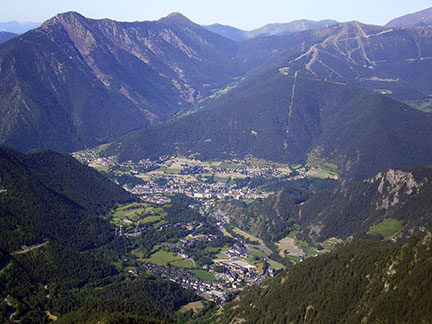
About AndorraSatellite View is showing the Principality of Andorra, a small, landlocked state located in the east Pyrenees between France and Spain. The towns of La Massana and Ordino (in the foreground) viewed from the peak of Casamanya (2,740 m) in the Pyrenees. The main industry in the country is tourism, but it also earns some foreign income because it's a small tax-haven. One of Europe's smallest states occupies an area of 468 km² compared it is about half the size of the city of Berlin or 2.5 times the size of Washington, DC. Andorra has a population of 76,000 people (official estimate 2012). Capital city is Andorra la Vella. Spoken languages are Catalan (official) 39%, Spanish 35% Portuguese 15%, and French 5%. The map shows Andorra with cities, towns, expressways, main roads and streets. To find a location use the form below. To view just the map, click on the "Map" button. |
|
| To find a location type: street or place, city, optional: state, country. |
Local Time Andorra:
Wednsday-April-24 06:08
Standard Time Zone (CET): UTC/GMT +1 hourCEST (Daylight Saving Time) in use from end of March until end of October. Time zone offset: UTC/GMT +2 hours |
One World - Nations Online .:. let's care for this planet Promote that every nation assumes responsibility for our world. Nations Online Project is made to improve cross-cultural understanding and global awareness. More signal - less NOISE |
| Site Map
| Information Sources | Disclaimer | Copyright © 1998-2023 :: nationsonline.org |