Nations Online
All Countries in the World
Nations Online All Countries in the World | |
Home  |
___ Famous Landmarks - Satellite View of Forbidden City - 紫禁城 |
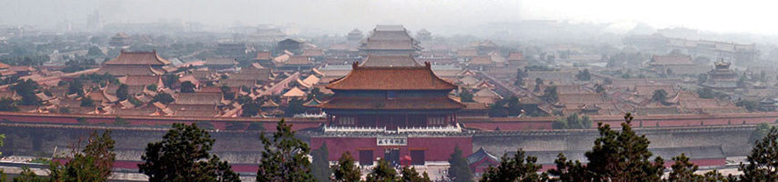 The Purple Forbidden City, viewed from Jingshan Hill. Image by: Simm |
About the Forbidden City The Imperial Palaces of the Ming and Qing dynasties in Beijing were the very center of Chinese imperial power, the center of the world - in an imperial point of view. The Imperial Palaces of the Ming and Qing dynasties in Beijing were the very center of Chinese imperial power, the center of the world - in an imperial point of view. The complex of buildings was the Imperial City, within lies the 'Forbidden City' (Chin.: 紫禁城; zǐ jìn chéng, or the „Purple Forbidden City“ or Chin.: 故宫, gù gōng „Emperor Palace, heavenly palace“). Today the complex is formally called Palace Museum. For almost five centuries, the Emperor Palace served as the home of the Emperor and his household. No commoner or foreigner was allowed to enter it without special permission. The complex consists of almost 1000 buildings on an area of 720,000 square meters, it is surrounded by a 8 m high city wall and a six-meter deep, 52-meter wide moat. It is the largest cluster of well preserved ancient buildings in the world. Construction began in 1406 and took about 14 years. Satellite view is showing the Forbidden City in Beijing On the map you will find the description of the main buildings of the Forbidden City. Zoom out to see the Temples of the Sun (in east), the Moon (in west), Earth (north) and the Temple of Heaven (south of Forbidden City.) |
|
φ Latitude, λ Longitude (of Map center; move the map to see coordinates): , |
|
| Sorry! Google's pricing policy has made it impossible for us to continue showing Google Maps. We apologize for any inconvenience. Google Map: Satellite View of Forbidden City, Beijing. (Make sure 3D Buildings is checked in the Layers panel in Google Earth) |
Bookmark/share this page |
| Coordinates (WGS 84): 39° 54′ 53″ N, 116° 23′ 26″ E |
|
| previous landmark: Empire State Building, New York City | next landmark: Sydney Opera House, Sydney, Australia |
More about China: History: Other Landmarks: Cities - City description with a searchable map and satellite view of: Beijing, Chongqing, Guangzhou, Lhasa (Tibet), Shanghai, Tianjin, Hong Kong (SAR), Macau (SAR) Country: China key statistical data. Continent: External Links: Palace Museum, Beijing Beijing Municipal Government Beijing's official site. eBeijing International A guide to Beijing, the Official Website of the Beijing Government, the website provides information in news, investment, employment, tourism, and regulations. Beijing Tourism Information The official Beijing travel and tourism site. |
Explore more:
Related Consumer Information:
|
| Countries and Territories of Asia | |
Map Help [ show ] |
|
One World - Nations Online .:. let's care for this planet Promote that every nation assumes responsibility for our world. Nations Online Project is made to improve cross-cultural understanding and global awareness. More signal - less NOISE |
| Site Map
| Information Sources | Disclaimer | Copyright © 1998-2024:: nationsonline.org |
