
| Home |
|
|
|
___ Political and Administrative Map of El Salvador |
|
About El Salvador |
|
| El Salvador is a mountainous country in western Central America bordered by the Pacific ocean in south, Guatemala in west and Honduras in north and it shares maritime borders with Nicaragua. With an area of 21,000 km², it is the smallest Central American country about the size of Slovenia or slightly smaller than the U.S. state of Massachusetts. The county's highest elevation is Cerro El Pital with 2,730 m. El Salvador has a population of 6,426,000 people (in 2015), Capital is San Salvador; official language is Spanish. The map is showing El Salvador and the neighboring countries with international borders, department boundaries, the national capital San Salvador, department capitals, major cities, main roads, railroads and major airports. |
 Bookmark/share this page |
 One World - Nations Online All Countries of the World |
|
|
||
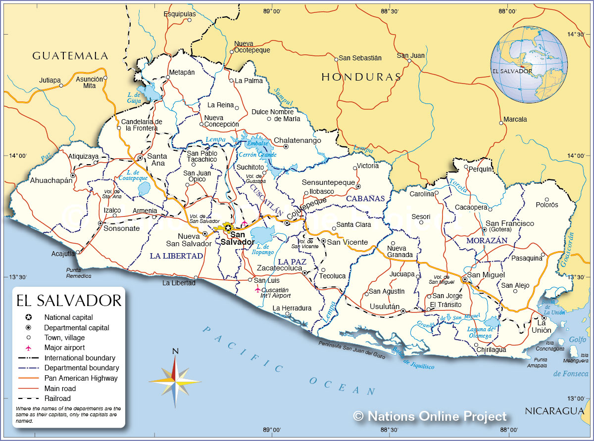 Political and Administrative Map of El Salvador Map based on a UN map. Source: UN Cartographic Section |
|||||||
| Departments (departamentos) of El Salvador The map shows the country's first level administrative divisions, the 14 departments of El Salvador The departments (abbreviation in parentheses) and their capitals are: Ahuachapán (AH) - Capital: Ahuachapán; Cabañas (CA) - Capital: Sensuntepeque; Chalatenango (CH) - Capital: Chalatenango; Cuscatlán (CU) - Capital: Cojutepeque; La Libertad (LI) - Capital: Santa Tecla; La Paz (PA) - Capital: Zacatecoluca; La Unión (UN) - Capital: La Unión; Morazán (MO) - Capital: San Francisco Gotera; San Miguel (SM) - Capital: San Miguel; San Salvador (SS) - Capital: San Salvador; San Vicente (SV) - Capital: San Vicente; Santa Ana (SA) - Capital: Santa Ana; Sonsonate (SO) - Capital: Sonsonate; Usulután (US) - Capital: Usulután |
|||||||
| Cities in El Salvador The map shows the location of Salvadoran cities and towns by departments: Ahuachapán Ahuachapán (capital), Atiquizaya Cabañas Sensuntepeque (capital), Ilobasco, Victoria Chalatenango Chalatenango (capital), Dulce Nombre de María, La Palma, La Reina, Nueva Concepción Cuscatlán Cojutepeque (capital), Suchitoto La Libertad Nueva San Salvador also Santa Tecla (capital), La Libertad, San Juan Opico, San Pablo Tacachico La Paz Zacatecoluca (capital), La Herradura, San Luis La Unión La Unión (capital), Pasaquina, Polorós, San Alejo Morazán San Francisco (Gotera) (capital), Cacaopera, Perquín San Miguel San Miguel (capital), Carolina, Chirilagua, El Tránsito, San Jorge, Sesori San Salvador San Salvador (capital) San Vicente San Vicente (capital), Santa Clara, Tecoluca Santa Ana Santa Ana (capital), Candelaria de la Frontera, Metapán Sonsonate Sonsonate (capital), Acajutla, Armenia, Izalco Usulután Usulután (capital), Jucuapa, Nueva Granada, San Agustín |
More about El Salvador: Cities: Country: Continent: |
Current Weather Conditions San Salvador:
|
Explore More:
Related Consumer Information:
|
||||
| Maps of other Countries in Central America: Belize Map, Costa Rica Map, Guatemala Map, Honduras, Mexico Map, Nicaragua Map, Panama Map Maps of Caribbean Islands Cuba Map, Dominican Republic, Haiti Map, Jamaica Map, Puerto Rico Map | |||||||
One World - Nations Online .:. let's care for this planet Every nation is responsible for the current state of our world. |
| Site Map
| Information Sources | Disclaimer: Privacy Policy, etc. Contact: [email protected] | Copyright © 1998-2021 :: nationsonline.org |
