| Home |
|
 |
|
___ Political Map of Panama |
|
About Panama |
|
| Panama is a country on the Isthmus of Panama, the landbridge between the Caribbean Sea and the Pacific Ocean, that links North and South America. It is bordered by Colombia and Costa
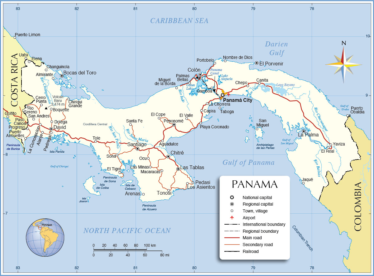
Rica. With an area of 75,517 km², Panama is slightly larger than the Republic of Ireland or slightly smaller than the U.S. state of South Carolina. Major rivers in Panama are Rio Balsas, Rio Changuinola, Rio Chepo, Rio Chucunaque, Rio Indo, Rio San Pablo, and Rio Santa Maria. The highest point in Panama is Volcan Baru with 3,475 m (11,460 feet) located in west close to the border with Costa Rica. Panama has a population of 3 million people; capital is Panama City; official language is Spanish. Map is showing the Central American country with international borders, the national capital Panamá City, provincial capitals, major cities, main roads, major airports and the only functioning railway in Panama, the Panama Canal Railway. The map also shows the location of the about 80 km (50 mi) long Panama Canal, running from north to south across the Isthmus of Panama, and connects the Caribbean Sea (Atlantic) with the Pacific Ocean. It is an important waterway for the international trade. The Colombia trench, a very deep and asymmetrical depression of the Pacific sea floor south of Panama and running parallel along the coast of Colombia. |
 Bookmark/share this page 
|
 One World - Nations Online All Countries of the World |
|
|
||
 Political Map of Panama |
|||||||
| Cities and Towns of Panama Map shows the location of following Panamanian cities and towns: Aguadulce, Alanje, Almirante, Arenas, Bocas del Toro, Boquette, Canita, Capira, Cerro Punta, Changuinola, Chepo, Chiriqui Grande, Chitré, Colón, David, Dolega, El Cope, El Porvenir, El Real, El Tigre, El Valle, Elena, Gamboa, Jaqué, La Chorrera, La Concepcion, La Palma, Las Minas, Las Tablas, Los Asientos, Macaracas, Miguel de la Borda, Nombre de Dios, Ocu, Palmas Bellas, Panamá City, Paso Canoa, Pedasi, Pedregalal, Penonomé, Playa Coronado, Portobelo, Progreso, Puerto Armuelles, Puerto Obaldia, Rio Sereno, San Andres, San Miguel, Santa Fe, Santiago, Sona, Taboga, Tole, Tonosi, Volcan, and Yaviza. |
More about Panama: Landmarks: Cities: Country: Continent: |
Panama City Weather Conditions |
Related Consumer Information:
|
||||
| Maps of other Countries in Central America: Belize Map, Costa Rica Map, El Salvador Map, Guatemala Map, Honduras, Mexico Map, Nicaragua Map Maps of Caribbean Islands Cuba Map, Dominican Republic, Haiti Map, Jamaica Map, Puerto Rico Map | |||||||
One World - Nations Online .:. let's care for this planet Every nation is responsible for the current state of our world. |
| Site Map
| Information Sources | Disclaimer: Privacy Policy, etc. Contact: [email protected] | Copyright © 1998-2021 :: nationsonline.org |