Nations Online
All Countries in the World
Nations Online All Countries in the World | |
Home  |
___ Satellite View and Map of the City of Bujumbura, Burundi |
About BujumburaSatellite view is showing Bujumbura, largest city and national capital ofUntil independence of Burundi the city was known as Usumbura. Bujumbura is situated at the north-eastern corner of Lake Tanganyika and is the country's chief port. Most of the country's export is shipped from there. The city has an estimated population of about 500,000 inhabitants. Spoken languages are French (official) and Kirundi. Some points of interest you can visit from Bujumbura: Lake Tanganyika beaches (freshwater fun), Rusizi National Park (meet Gustave, a Nile crocodile rumored to have killed 300 people), Livingstone–Stanley Monument (Dr Livingstone, I presume?), Kibira National Park (primeval rain forest), Chutes de la Kagera (falling waters) The map shows a city map of Bujumbura with expressways, main roads and streets, and the location of Bujumbura International Airport (IATA code: BJM). To find a location use the form below. |
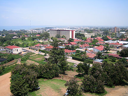 Central Bujumbura, with Lake Tanganyika in the background. Image: Amakuru Bookmark/share this page |
| To find a location type: street or place, city, optional: state, country. |
Local Time Botswana:
Wednsday-April-24 05:21
Time Zone: Central Africa Time (CAT) GMT/UTC +2 |
One World - Nations Online .:. let's care for this planet Promote that every nation assumes responsibility for our world. Nations Online Project is made to improve cross-cultural understanding and global awareness. More signal - less NOISE |
| Site Map
| Information Sources | Disclaimer | Copyright © 1998-2023 :: nationsonline.org |

