Nations Online
All Countries in the World
Nations Online All Countries in the World | |
Home  |
___ Satellite View and Map of Africa |
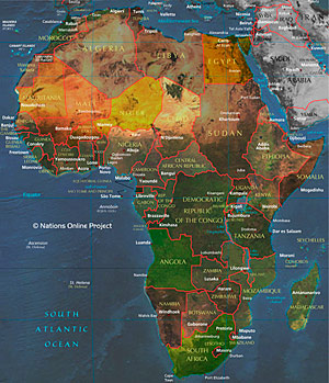
Searchable Map of Africa using Google Earth DataSatellite View is showing Africa the world's second largest continent, 30,244,000 km² (11,700,000 mi²) including its adjacent islands, it covers about 20 percent of Earth's total land area.Africa is bordered by the Mediterranean Sea in north, the Sinai Peninsula, the Red Sea and the Gulf of Aden in north east, the Indian Ocean in southeast, and the North- and South Atlantic Ocean in west. The continent includes the island country of Madagascar (fourth-largest island in the world) and some smaller archipelagoes. The distance from the continent's northern coast to South Africa's shore line is about 8,000 km (5,000 mi). The Equator (latitude 0 degrees) divides the continent into almost two equal parts of north and south. Africa is also home to 14 percent of the world population, more than 3 times the population of the USA, but still lesser than the population of India. Africa is divided in 54 countries, most of the borders which separates countries are a legacy of the century long colonization of the continent, drawn arbitrary without regards to cultural affiliations between the indigenous people. The map shows Africa with the location of countries, cities, places, expressways, main roads and streets (To view the map, click on the "Map" button.) Find any place in Africa. To find a location use the form below. You may try for example: some African landmarks like: Kilimanjaro (Tanzania), Victoria Falls (Zambia and Zimbabwe), Serengeti National Park (Tanzania) or Kruger National Park (South Africa), go to Africa's largest lake -- Lake Victoria, one of the African Great Lakes, or have a look at the dunes of the Sahara, the world's largest hot desert which covers most of North Africa. You might search for the Blue Nile, one of the two major tributaries of the river Nile and you will land in Ethiopia near Lake Tana. You also can find man-made landmarks like the Pyramids of Giza (Egypt), or the Suez Channel. |
 Map of Africa Bookmark/share this page |
| To find a location type: street or place, city, optional: state, country. |
|
|
φ Latitude, λ Longitude (of Map center; move the map to see coordinates): , |
||
| Google Earth: Searchable map and satellite view of Africa. |
||
|
|
||
| More about Africa: |
Related Consumer Information:
|
|
African Countries Algeria, Angola, Benin, Botswana, Burkina Faso, Burundi, Cameroon, Cape Verde, Central African Republic, Chad, Comoros, Congo-Brazzaville, Congo-Kinshasa, Cote d'Ivoire, Djibouti, Egypt, Equatorial Guinea, Eritrea, Ethiopia, Gabon, Gambia, Ghana, Guinea, Guinea-Bissau, Kenya, Lesotho, Liberia, Libya, Madagascar, Malawi, Mali, Mauritania, Mauritius, Morocco, Mozambique, Namibia, Niger, Nigeria, Reunion, Rwanda, Sao Tome and Principe, Senegal, Seychelles, Sierra Leone, Somalia, South Africa, Sudan, Swaziland, Tanzania, Togo, Tunisia, Uganda, Zambia, Zimbabwe |
||
Map Help [ show ] |
||
One World - Nations Online .:. let's care for this planet Promote that every nation assumes responsibility for our world. Nations Online Project is made to improve cross-cultural understanding and global awareness. More signal - less NOISE |
| Site Map
| Information Sources | Disclaimer | Copyright © 1998-2023 :: nationsonline.org |
